Fort Chipewyan
| Fort Chipewyan | |
|---|---|
| Hamlet | |
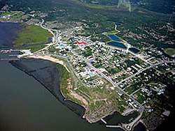 Aerial view of Fort Chipewyan | |
 Fort Chipewyan Location of Fort Chipewyan in Alberta | |
| Coordinates: 58°42′52″N 111°09′30″W / 58.7144°N 111.1583°W | |
| Country |
|
| Province |
|
| Region | Northern Alberta |
| Census division | 16 |
| Specialized municipality | RM of Wood Buffalo |
| Settled | 1788[1] |
| Government | |
| • Type | Unincorporated |
| • Mayor | Don Scott |
| • Governing body |
Wood Buffalo Municipal Council
|
| Area (2011)[2] | |
| • Total | 10.23 km2 (3.95 sq mi) |
| • Water | 10.70 km2 (4.13 sq mi) |
| Elevation[3] | 221 m (725 ft) |
| Population (2016)[2] | |
| • Total | 852 |
| • Density | 79.6/km2 (206/sq mi) |
| Time zone | UTC−7 (MST) |
| • Summer (DST) | UTC−6 (MDT) |
| Postal code | T9K |
| Area code(s) | +1-780 |
| Climate | Dfc |
Fort Chipewyan /ˈtʃɪpəwaɪən,
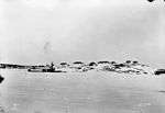
History
.jpg)
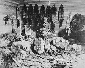
Fort Chipewyan is one of the oldest European settlements in the Province of Alberta. It was established as a trading post by Peter Pond of the North West Company in 1788.[1] The fort was named after the Chipewyan people living in the area.
One of the establishers of the fort, Roderick Mackenzie of Terrebonne, always had a taste for literature, as was seen years later when he opened correspondence with traders all over the north and west, asking for descriptions of scenery, adventure, folklore and history. He also had in view the founding of a library at the fort, which would not be only for the immediate residents of Fort Chipewyan, but for traders and clerks of the whole region tributary to Lake Athabasca, so that it would be what he called, in an imaginative and somewhat jocular vein, "the little Athens of the Arctic regions." This library, built in 1790, held over 2000 books,[5] and became one of the most famous in the whole extent of Rupert's Land.[6][7]
From about 1815 to 1821 the Hudson's Bay Company (HBC) maintained a competing Fort Wedderburn (named after Andrew Colvile's family) on Coal Island a mile and a half from the North West Company's fort.[8] This fort was established by John Clarke, and Sir George Simpson arrived here in 1820-1821, where he began to reorganize the fur trade.[5]
Sir John Franklin set out from Fort Chipewyan on his overland Arctic journey on 1820. In 1887 - 1888 there was a great famine. Electric lights did not arrive in Fort Chipewyan until 1959.[5]
Historic sites
Old Fort Point, the site of the first Fort Chipewyan established in 1788 by Roderick Mackenzie, southeast of Fort Chipewyan was designated a National Historic Site of Canada in 1930.[9] Historic places in the community include the site of the third Fort Chipewyan established in 1803,[10] the Anglican Church built in 1880 and Day School built in 1874,[11] and the Roman Catholic Mission Church built in 1909.[12]
Demographics
As a designated place in the 2016 Census of Population conducted by Statistics Canada, Fort Chipewyan recorded a population of 852 living in 295 of its 372 total private dwellings, a change of 0.6% from its 2011 population of 847. With a land area of 10.7 km2 (4.1 sq mi), it had a population density of 79.6/km2 (206.2/sq mi) in 2016.[13]
The population of Fort Chipewyan in 2012 was 1,008 according to a municipal census conducted by the R.M of Wood Buffalo.[14]
As a designated place in the 2011 Census, Fort Chipewyan had a population of 847 living in 302 of its 358 total dwellings, a 12% change from its 2006 population of 756. With a land area of 10.23 km2 (3.95 sq mi), it had a population density of 82.80/km2 (214.44/sq mi) in 2011.[2]
The hamlet's population is predominantly made up of Cree First Nations, Chipewyan (Dene) First Nations, and Metis people.
Transportation
Air
The hamlet is served by the Fort Chipewyan Airport, opened on June 18, 1966.[5] Air is one of two methods of access to Fort Chipewyan in the summer.[15]
Water
In the summer, the hamlet also can be accessed by boat [15] from Fort McMurray via the Athabasca River.
Road
There are no all-weather roads to Fort Chipewyan,[16] but it can be reached via winter roads in the winter.[17] These include roads from Fort Smith to the north and from Fort McMurray to the south. In June 1998, and as part of the Northwestern Canadian Integrated Road Network Plan, the Alberta government conducted studies on all-weather road access by extending the existing Highway 63 from Fort McMurray.[18] As of 2008 Highway 63 has been extended from Fort McMurray to Syncrude; there are currently no plans on extending it further to Fort Chipewyan.[18] In December 2005, one-third of Fort Chipewyan's residents signed a petition to request the government to build a 50 km (31 mi) all-weather road to connect with existing roads to the northwest that provide access to Fort Smith, Northwest Territories. The major expenditure would be a bridge over the Slave River.
Climate
Fort Chipewyan has a subarctic climate (Köppen Dfc) with long, very cold, dry winters and short, warm, wetter summers. The highest temperature ever recorded in Fort Chipewyan was 34.7 °C (94.5 °F) on 27 June 2002.[19] The coldest temperature ever recorded was −51.1 °C (−60 °F) on 1 February 1917.[20]
| Climate data for Fort Chipewyan Airport, 1981–2010 normals, extremes 1883–present[lower-alpha 1] | |||||||||||||
|---|---|---|---|---|---|---|---|---|---|---|---|---|---|
| Month | Jan | Feb | Mar | Apr | May | Jun | Jul | Aug | Sep | Oct | Nov | Dec | Year |
| Record high °C (°F) | 10.5 (50.9) |
15.0 (59) |
14.5 (58.1) |
27.1 (80.8) |
32.3 (90.1) |
34.7 (94.5) |
34.0 (93.2) |
34.1 (93.4) |
31.2 (88.2) |
26.5 (79.7) |
17.0 (62.6) |
13.9 (57) |
34.7 (94.5) |
| Average high °C (°F) | −16.5 (2.3) |
−12.5 (9.5) |
−4.6 (23.7) |
5.5 (41.9) |
13.8 (56.8) |
20.4 (68.7) |
23.0 (73.4) |
20.9 (69.6) |
14.0 (57.2) |
4.8 (40.6) |
−6.7 (19.9) |
−13.2 (8.2) |
4.1 (39.4) |
| Daily mean °C (°F) | −21.9 (−7.4) |
−18.4 (−1.1) |
−11.3 (11.7) |
−0.6 (30.9) |
7.7 (45.9) |
14.1 (57.4) |
17.0 (62.6) |
14.9 (58.8) |
8.7 (47.7) |
0.6 (33.1) |
−11.1 (12) |
−18.2 (−0.8) |
−1.5 (29.3) |
| Average low °C (°F) | −27.1 (−16.8) |
−24.3 (−11.7) |
−18.0 (−0.4) |
−6.6 (20.1) |
1.5 (34.7) |
7.8 (46) |
11.0 (51.8) |
8.9 (48) |
3.4 (38.1) |
−3.6 (25.5) |
−15.4 (4.3) |
−23.2 (−9.8) |
−7.1 (19.2) |
| Record low °C (°F) | −50.0 (−58) |
−51.1 (−60) |
−47.8 (−54) |
−35.6 (−32.1) |
−25.6 (−14.1) |
−7.0 (19.4) |
−3.9 (25) |
−6.7 (19.9) |
−12.2 (10) |
−30.0 (−22) |
−39.8 (−39.6) |
−49.4 (−56.9) |
−51.1 (−60) |
| Average precipitation mm (inches) | 14.9 (0.587) |
14.1 (0.555) |
15.8 (0.622) |
16.0 (0.63) |
27.2 (1.071) |
44.4 (1.748) |
67.4 (2.654) |
50.2 (1.976) |
44.0 (1.732) |
28.8 (1.134) |
24.5 (0.965) |
18.4 (0.724) |
365.7 (14.398) |
| Average rainfall mm (inches) | 0.3 (0.012) |
0.1 (0.004) |
0.2 (0.008) |
6.2 (0.244) |
24.5 (0.965) |
44.4 (1.748) |
67.4 (2.654) |
50.2 (1.976) |
43.2 (1.701) |
13.3 (0.524) |
0.4 (0.016) |
0.2 (0.008) |
250.4 (9.858) |
| Average snowfall cm (inches) | 14.8 (5.83) |
14.4 (5.67) |
15.7 (6.18) |
9.8 (3.86) |
2.7 (1.06) |
0.0 (0) |
0.0 (0) |
0.0 (0) |
0.7 (0.28) |
15.5 (6.1) |
24.7 (9.72) |
18.5 (7.28) |
116.9 (46.02) |
| Source: Environment Canada[19][21][20][22] | |||||||||||||
Solar energy
In September 2014, the community of Fort Chipewyan in collaboration with Keepers of the Athabasca installed a 1.8 kW solar array on the roof of the Elder Lodge to be used for emergency backup power.[23] An energy baseline study was completed for Fort Chipewyan by the Pembina Institute in 2012.[24]
The table below shows the mean daily global insolation (kWh/m2) in Fort Chipewyan for each month of the year using five different fixed solar array orientations and one which tracks the sun. The data was provided by Natural Resources Canada's Municipality database of photovoltaic potential and insolation [25] which used data collected over 50 years from 144 locations compiled from Environment Canada's CERES CD.[26]
| Month | South facing (tilt = vertical) | South facing (tilt = latitude) | South facing (tilt = lat+15o | South facing (tilt = lat-15o | Two-axis sun-tracking | Horizontal (tilt=0o) |
|---|---|---|---|---|---|---|
| January | 2.64 | 2.46 | 2.63 | 2.14 | 2.86 | 0.56 |
| February | 4.23 | 4.17 | 4.33 | 3.77 | 5.02 | 1.42 |
| March | 5.48 | 5.92 | 5.88 | 5.65 | 7.74 | 3.02 |
| April | 4.95 | 6.26 | 5.78 | 6.41 | 9.38 | 4.71 |
| May | 3.82 | 5.55 | 4.84 | 6.02 | 9.59 | 5.82 |
| June | 3.38 | 5.2 | 4.43 | 5.78 | 9.76 | 6.23 |
| July | 3.38 | 5.09 | 4.37 | 5.61 | 9.26 | 5.82 |
| August | 3.66 | 5.04 | 4.51 | 5.34 | 8.19 | 4.5 |
| September | 3.35 | 4.04 | 3.82 | 4.03 | 5.56 | 2.8 |
| October | 2.68 | 2.85 | 2.86 | 2.69 | 3.51 | 1.49 |
| November | 2.16 | 2.07 | 2.18 | 1.84 | 2.42 | 0.65 |
| December | 1.98 | 1.82 | 1.96 | 1.56 | 2.09 | 0.34 |
| Annual | 3.47 | 4.2 | 3.96 | 4.24 | 6.29 | 3.12 |
See also
References
- 1 2 Athabasca Tribal Council – Athabasca Chipewyan First Nation Archived 2009-02-23 at the Wayback Machine.
- 1 2 3 "Population and dwelling counts, for Canada, provinces and territories, and designated places, 2011 and 2006 censuses (Alberta)". Statistics Canada. 2012-02-08. Retrieved 2012-04-07.
- ↑ "Alberta Private Sewage Systems 2009 Standard of Practice Handbook: Appendix A.3 Alberta Design Data (A.3.A. Alberta Climate Design Data by Town)" (PDF) (PDF). Safety Codes Council. January 2012. pp. 212–215 (PDF pages 226–229). Retrieved October 8, 2013.
- ↑ Alberta Municipal Affairs (2010-04-01). "Specialized and Rural Municipalities and Their Communities" (PDF). Archived from the original (PDF) on 2012-02-29. Retrieved 2010-07-10.
- 1 2 3 4 Ft. Chipewyan Bicentennial Museum, 2013,
- ↑ Bryce, George (1910). MacKenzie - Selkirk - Simpson - The Makers of Canada. Toronto: Morang & Co. pp. 21–30. ISBN 978-1-4067-3242-9.
- ↑ Bryce, George (1911). The Scotsman in Canada. Toronto: Musson Book Co.
- ↑ Raffan, James (2007). Emperor Of The North: Sir George Simpson and the Remarkable Story of the Hudson's Bay Company. HarperCollins Canada. pp. 108–119. ISBN 978-1-4434-0139-5.
- ↑ Fort Chipewyan. Canadian Register of Historic Places. Retrieved 25 November 2013.
- ↑ Fort Chipewyan III. Canadian Register of Historic Places. Retrieved 23 December 2014.
- ↑ 1880 Angican Church of St. Paul the Apostle and the 1874 Day School. Canadian Register of Historic Places. Retrieved 23 December 2014.
- ↑ Nativity of the Blessed Virgin Roman Catholic Church. Canadian Register of Historic Places. Retrieved 23 December 2014.
- ↑ "Population and dwelling counts, for Canada, provinces and territories, and designated places, 2016 and 2011 censuses – 100% data (Alberta)". Statistics Canada. February 8, 2017. Retrieved February 13, 2017.
- ↑ "Municipal Census 2012: Count Yourself In!" (PDF). Regional Municipality of Wood Buffalo. p. 24. Archived from the original (PDF) on March 26, 2013. Retrieved January 26, 2013.
- 1 2 "Fort Chipewyan". Regional Municipality of Wood Buffalo. Retrieved 2018-02-11.
- ↑ "Parks Canada". Parks Canada.
- ↑ "Fort Chipewyan Winter Road". Regional Municipality of Wood Buffalo. Retrieved 2018-02-11.
- 1 2 "Northern Highways Strategy" (PDF). Northern Alberta Development Council. Northern Alberta Development Council. October 2008.
- 1 2 "Fort Chipewyan, Alberta". Canadian Climate Normals 1981–2010 (in English and French). Environment Canada. Retrieved March 28, 2014.
- 1 2 "Daily Data Report for February 1917". Canadian Climate Data. Environment Canada. Retrieved 1 July 2016.
- ↑ "Fort Chipewyan". Canadian Climate Data. Environment Canada. Retrieved 1 July 2016.
- ↑ "Daily Data Report for September 2011". Canadian Climate Data. Environment Canada. Retrieved 1 July 2016.
- ↑ "MAKING A STATEMENT IN FORT CHIP". Alberta EcoTrust. Retrieved 17 April 2018.
- ↑ Huot, Marc. "Fort Chipewyan Community Energy Baseline" (PDF). Keepers of the Athabasca. Pembina Institute. Retrieved 17 April 2018.
- ↑ "Photovoltaic and solar resource maps". Natural Resources Canada. Retrieved 17 April 2018.
- ↑ Pelland, S (Aug 20, 2006). "The Development of Photovoltaic Resource Maps for Canada" (PDF). 31st Annual Conference of the Solar Energy Society of Canada (SESCI). Aug. 20-24th 2006, Montréal Canada. Retrieved 17 April 2018.
- ↑ Climate data was recorded at Fort Chipewyan from October 1883 to October 1967 and at Fort Chipewyan Airport from November 1967 to present.
External links
| Wikimedia Commons has media related to Fort Chipewyan. |
Places adjacent to Fort Chipewyan | ||||||||||
|---|---|---|---|---|---|---|---|---|---|---|
| ||||||||||
Coordinates: 58°42′52″N 111°09′30″W / 58.71444°N 111.15833°W