Finleyville, Pennsylvania
| Finleyville | |
|---|---|
| Borough | |
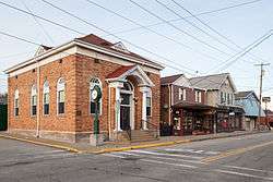 Borough building at the intersection of Washington and Extension Avenues, December 2014 | |
| Etymology: John Finley | |
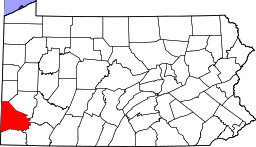
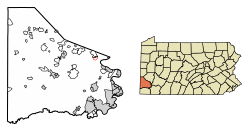 Location of Finleyville in Washington County, Pennsylvania. | |
 Finleyville Location of Finleyville in Pennsylvania | |
| Coordinates: 40°15′10″N 80°0′13″W / 40.25278°N 80.00361°WCoordinates: 40°15′10″N 80°0′13″W / 40.25278°N 80.00361°W | |
| Country | United States |
| State | Pennsylvania |
| County | Washington |
| Established | 1896 |
| Government | |
| • Mayor | Michael M. Kutsek |
| Area[1] | |
| • Total | 0.17 sq mi (0.43 km2) |
| • Land | 0.17 sq mi (0.43 km2) |
| • Water | 0.00 sq mi (0.00 km2) |
| Population (2010) | |
| • Total | 461 |
| • Estimate (2016)[2] | 407 |
| • Density | 2,437.13/sq mi (939.49/km2) |
| Time zone | UTC-4 (EST) |
| • Summer (DST) | UTC-5 (EDT) |
| ZIP code | 15332 |
| Area code(s) | 724 |
| Website | www.finleyvilleboro.com |
Finleyville is a borough in Washington County, Pennsylvania, United States, named for John Finley. It was built at the junction of Brownsville Road (now Pennsylvania Route 88 ) and the 'Washington Road' from Cox's Fort to Catfish Camp, now Washington, Pennsylvania.[3] It was originally known as "Rowgalley" until after a large contingent of Scots-Irish came to town including a number of "Finleys." Reporter Ben Finley's family originates from Finleyville.[4] It is in the Peters Creek watershed. The population was 461 at the 2010 census.
Geography
Finleyville is located at 40°15′10″N 80°0′13″W / 40.25278°N 80.00361°W (40.252662, -80.003505).[5]
According to the United States Census Bureau, the borough has a total area of 0.2 square miles (0.52 km2), all of it land.
Demographics
| Historical population | |||
|---|---|---|---|
| Census | Pop. | %± | |
| 1900 | 447 | — | |
| 1910 | 644 | 44.1% | |
| 1920 | 609 | −5.4% | |
| 1930 | 595 | −2.3% | |
| 1940 | 699 | 17.5% | |
| 1950 | 684 | −2.1% | |
| 1960 | 582 | −14.9% | |
| 1970 | 379 | −34.9% | |
| 1980 | 402 | 6.1% | |
| 1990 | 446 | 10.9% | |
| 2000 | 459 | 2.9% | |
| 2010 | 461 | 0.4% | |
| Est. 2016 | 407 | [2] | −11.7% |
| Sources:[6][7][8] | |||
As of the census[7] of 2000, there were 459 people, 240 households, and 112 families residing in the borough. The population density was 2,729.7 inhabitants per square mile (1,053.9/km2). There were 271 housing units at an average density of 1,611.6 per square mile (615.5/km²). The racial makeup of the borough was 91.72% White, 5.88% African American, 0.87% Asian, 0.22% from other races, and 1.31% from two or more races. Hispanic or Latino of any race were 0.65% of the population.
There were 240 households out of which 22.5% had children under the age of 18 living with them, 32.1% were married couples living together, 12.1% had a female householder with no husband present, and 53.3% were non-families. 50.0% of all households were made up of individuals and 18.8% had someone living alone who was 65 years of age or older. The average household size was 1.91 and the average family size was 2.82.
In the borough the population was spread out with 20.0% under the age of 18, 6.1% from 18 to 24, 35.3% from 25 to 44, 19.8% from 45 to 64, and 18.7% who were 65 years of age or older. The median age was 38 years. For every 100 females, there were 92.1 males. For every 100 females age 18 and over, there were 90.2 males.
The median income for a household in the borough was $29,375, and the median income for a family was $38,125. Males had a median income of $31,818 versus $21,827 for females. The per capita income for the borough was $18,387. About 9.3% of families and 11.1% of the population were below the poverty line, including 12.1% of those under age 18 and 23.9% of those age 65 or over.
References
- ↑ "2016 U.S. Gazetteer Files". United States Census Bureau. Retrieved Aug 14, 2017.
- 1 2 "Population and Housing Unit Estimates". Retrieved June 9, 2017.
- ↑ "Finleyville, Its Early Beginnings". Retrieved 2008-07-02.
- ↑ Fleming, George T (1922). History of Pittsburgh and environs, from prehistoric days to the beginning of the American Revolution. New York, Chicago: American Historical Society. pp. 30–32. OCLC 19808084. Retrieved 2009-03-02.
- ↑ "US Gazetteer files: 2010, 2000, and 1990". United States Census Bureau. 2011-02-12. Retrieved 2011-04-23.
- ↑ "Census of Population and Housing". U.S. Census Bureau. Archived from the original on 12 May 2015. Retrieved 11 December 2013.
- 1 2 "American FactFinder". United States Census Bureau. Archived from the original on 2013-09-11. Retrieved 2008-01-31.
- ↑ "Incorporated Places and Minor Civil Divisions Datasets: Subcounty Resident Population Estimates: April 1, 2010 to July 1, 2012". Population Estimates. U.S. Census Bureau. Archived from the original on 17 June 2013. Retrieved 11 December 2013.
| Wikimedia Commons has media related to Finleyville, Pennsylvania. |
| Counties |  Map of the Pittsburgh Tri-State with green counties in the metropolitan area and yellow counties in the combined area. | |
|---|---|---|
| Major cities | ||
| Cities and towns 15k-50k (in 2010) | ||
| Airports | ||
| Topics | ||
| ||