Drumheller
| Drumheller | ||
|---|---|---|
| Town | ||
| Town of Drumheller | ||
 The view from "The World's Largest Dinosaur" facing west over the Red Deer River valley.' | ||
| ||
| Nickname(s): Dinosaur Capital of the World[1] | ||
 Drumheller Location of Drumheller in Alberta | ||
| Coordinates: 51°27′49″N 112°43′10″W / 51.46361°N 112.71944°W | ||
| Country |
| |
| Province |
| |
| Region | Southern Alberta | |
| Census division | 5 | |
| Founded | 1911 | |
| Incorporated[2] | ||
| • Village | May 15, 1913 | |
| • Town | March 2, 1916 | |
| • City | April 3, 1930 | |
| • Town | January 1, 1998 | |
| Amalgamated[2] | January 1, 1998 | |
| Government[3] | ||
| • Mayor | Heather Colberg | |
| • Governing body |
Drumheller Town Council
| |
| • CAO | Darryl Drohomerski | |
| • MP | Kevin Sorenson (Battle River-Crowfoot) | |
| • MLA | Rick Strankman (Drumheller-Stettler) | |
| Area (2016)[4] | ||
| • Land | 108.03 km2 (41.71 sq mi) | |
| Elevation[5] | 670 m (2,200 ft) | |
| Population (2016)[4] | ||
| • Total | 7,982 | |
| • Density | 73.9/km2 (191/sq mi) | |
| Time zone | UTC−7 (MST) | |
| • Summer (DST) | UTC−6 (MDT) | |
| Forward sortation area | T0J | |
| Area code(s) | +1-403, +1-587 | |
| Website | Official website | |

Drumheller /drʌmˈhɛlər/ is a town within the Red Deer River valley in the badlands of east-central Alberta, Canada. It is located 110 kilometres (68 mi) northeast of Calgary. The Drumheller portion of the Red Deer River valley, often referred to as Dinosaur Valley, has an approximate width of 2 kilometres (1.2 mi) and an approximate length of 28 kilometres (17 mi).
History
The Town of Drumheller was named after Samuel Drumheller, who, after purchasing the homestead of Thomas Patrick Greentree, had it surveyed into the original Drumheller townsite and put lots on the market in 1911.
Drumheller became a railway station in 1912.[6] It then incorporated as a village on May 15, 1913, a town on March 2, 1916 and a city on April 3, 1930.[7] Over a 15-year period, Drumheller's population increased 857% from 312 in 1916[8] to 2,987 in 1931[9] shortly after becoming a city.
The City of Drumheller amalgamated with the Municipal District (MD) of Badlands No. 7 on January 1, 1998 to form the current Town of Drumheller.[10] Some of the reasons the two municipalities amalgamated included the MD of Badlands No. 7 having more in common with Drumheller than other surrounding rural municipalities and both were experiencing similar planning and development issues due to their locations within the Red Deer River valley.[11] The amalgamated municipality opted for town status rather than city status so that highways within would remain the responsibility of the Province of Alberta.[12] As a result of the amalgamation, Drumheller became Alberta’s largest town in terms of land area at 107.93 square kilometres (41.67 sq mi).[13]
The 1998 amalgamation resulted in Drumheller absorbing six hamlets that were previously under the jurisdiction of the MD of Badlands No. 7 – Cambria, East Coulee, Lehigh, Nacmine, Rosedale and Wayne.[11] Drumheller also previously absorbed the hamlets of Bankview, Midlandvale (Midland), Newcastle and North Drumheller during annexations while under city status.[11] Bankview and Midland were annexed in 1964 and 1972 respectively, while Newcastle and North Drumheller were both annexed in 1967.[11] Other localities within Drumheller, either absorbed through past annexations or its eventual amalgamation with the MD of Badlands No. 7, include Aerial, Eladesor, Kneehill, Rosedale Station, Western Monarch (Atlas)[14] and Willow Creek.[15]
In total, Drumheller has absorbed at least 13 other communities in its history, some of which are now recognized as neighbourhoods or districts within the town.[16]
Demographics
In the 2016 Census of Population conducted by Statistics Canada, the Town of Drumheller recorded a population of 7,982 living in 3,164 of its 3,471 total private dwellings, a −0.6% change from its 2011 population of 8,029. With a land area of 108.03 km2 (41.71 sq mi), it had a population density of 73.9/km2 (191.4/sq mi) in 2016.[4]
In the 2011 Census, the Town of Drumheller had a population of 8,029 living in 3,182 of its 3,418 total dwellings, a 1.2% change from its 2006 population of 7,932. With a land area of 107.93 km2 (41.67 sq mi), it had a population density of 74.4/km2 (192.7/sq mi) in 2011.[13]
Climate
Drumheller experiences a Semi-arid climate (BSk). The highest temperature ever recorded in Drumheller was 40.6 °C (105 °F) on 18 July 1941.[17] The coldest temperature ever recorded was −43.9 °C (−47 °F) on 29 January 1996.[18]
| Climate data for Drumheller, 1981−2010 normals, extremes 1923−present | |||||||||||||
|---|---|---|---|---|---|---|---|---|---|---|---|---|---|
| Month | Jan | Feb | Mar | Apr | May | Jun | Jul | Aug | Sep | Oct | Nov | Dec | Year |
| Record high °C (°F) | 15.5 (59.9) |
18.0 (64.4) |
28.0 (82.4) |
33.9 (93) |
37.0 (98.6) |
39.4 (102.9) |
40.6 (105.1) |
38.1 (100.6) |
37.2 (99) |
33.3 (91.9) |
23.9 (75) |
17.3 (63.1) |
40.6 (105.1) |
| Average high °C (°F) | −6.0 (21.2) |
−0.4 (31.3) |
3.7 (38.7) |
12.9 (55.2) |
18.4 (65.1) |
22.1 (71.8) |
26.7 (80.1) |
26.1 (79) |
20.0 (68) |
13.2 (55.8) |
3.1 (37.6) |
−2.5 (27.5) |
11.4 (52.5) |
| Daily mean °C (°F) | −12.3 (9.9) |
−7.5 (18.5) |
−2.7 (27.1) |
5.9 (42.6) |
11.5 (52.7) |
15.8 (60.4) |
19.4 (66.9) |
18.3 (64.9) |
12.5 (54.5) |
5.9 (42.6) |
−3.0 (26.6) |
−8.8 (16.2) |
4.5 (40.1) |
| Average low °C (°F) | −18.6 (−1.5) |
−14.6 (5.7) |
−9.2 (15.4) |
−1.1 (30) |
4.5 (40.1) |
9.4 (48.9) |
12.0 (53.6) |
10.4 (50.7) |
4.9 (40.8) |
−1.4 (29.5) |
−9.1 (15.6) |
−15.1 (4.8) |
−2.3 (27.9) |
| Record low °C (°F) | −43.9 (−47) |
−41.4 (−42.5) |
−37.8 (−36) |
−26.7 (−16.1) |
−9.4 (15.1) |
−2.8 (27) |
−2.8 (27) |
−6.7 (19.9) |
−11.7 (10.9) |
−22.5 (−8.5) |
−35.1 (−31.2) |
−42.8 (−45) |
−43.9 (−47) |
| Average precipitation mm (inches) | 12.3 (0.484) |
10.2 (0.402) |
15.0 (0.591) |
25.7 (1.012) |
47.7 (1.878) |
69.3 (2.728) |
64.4 (2.535) |
51.4 (2.024) |
41.2 (1.622) |
13.4 (0.528) |
11.2 (0.441) |
10.4 (0.409) |
372.1 (14.65) |
| Average rainfall mm (inches) | 0.0 (0) |
0.1 (0.004) |
1.5 (0.059) |
20.5 (0.807) |
43.6 (1.717) |
69.3 (2.728) |
64.4 (2.535) |
51.0 (2.008) |
40.5 (1.594) |
9.7 (0.382) |
1.1 (0.043) |
0.0 (0) |
301.7 (11.878) |
| Average snowfall cm (inches) | 12.2 (4.8) |
10.1 (3.98) |
13.5 (5.31) |
5.2 (2.05) |
4.0 (1.57) |
0.0 (0) |
0.0 (0) |
0.4 (0.16) |
0.7 (0.28) |
3.8 (1.5) |
10.1 (3.98) |
10.4 (4.09) |
70.5 (27.76) |
| Source #1: Environment Canada[19][17][20][21][22][18][23] | |||||||||||||
| Source #2: Weatherbase[24] | |||||||||||||
Attractions
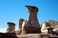
South of the traffic bridge over the Red Deer river on Highway 9 is the World's Largest Dinosaur, a 26.2-metre (86 ft) high fiberglass Tyrannosaurus rex that can be entered for a view of the Badlands, including the adjacent 23 metre (75 ft) water fountain, again one of the largest in Canada. Tourist attractions also include the Star Mine Suspension Bridge, Atlas Coal Mine, Canadian Badlands Passion Play, Horseshoe Canyon, Water Spray Park, Aquaplex with indoor and outdoor pools, Horse Thief Canyon, hoodoos, Midland Provincial Park, the Rosedeer Hotel in Wayne, 27 kilometres (17 mi) of constructed pathways, Bleriot Ferry, East Coulee School Museum, Homestead Museum, Valley Doll Museum and the Little Church which is capable of seating only six patrons.
Next to Drumheller ski hill is the Canadian Badlands Passion Play site, where, for two weeks each July, performances are held. Companies are composed of actors from all over Alberta. The site also offers small plays throughout the summer and an interpretive centre.
As of 2017, the town was the location of the Trekcetera Museum, which relocated from the town of Vulcan. The museum contains a collection of props, costumes and set pieces from the Star Trek franchise, as well as other productions ranging from the UK series Thunderbirds to shot-in-Alberta productions such as Superman III and Brokeback Mountain.
Royal Tyrrell Museum
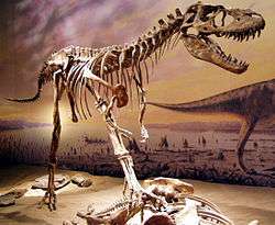
The Royal Tyrrell Museum of Palaeontology is a museum that hosts Canada's largest collection of dinosaur fossils. It boasts 375,000 visitors a year, the largest of all provincial museum attractions. It opened on September 25, 1985. The Royal Tyrrell Museum is located in the northwest quadrant of the Town of Drumheller, in Midland Provincial Park.
Media
Radio
- 99.5 DRUM FM: CHOO-FM, adult contemporary
- FM 94.5: CHTR-FM, tourist information
- AM 910: CKDQ, country music
- FM 91.3: CKUA-FM-13, public broadcasting (relay)
Newspapers
Newspapers covering Drumheller include the weekly Drumheller Mail, which has been publishing every Wednesday since 1911 and has been owned by the Sheddy family since 1954.
Television
All stations are analogue relays of stations from Calgary.
See also
References
- ↑ "The Dinosaur Capital of the World". traveldrumheller.com. Retrieved February 18, 2013.
- 1 2 "Location and History Profile: Town of Drumheller" (PDF). Alberta Municipal Affairs. June 17, 2016. p. 211. Retrieved June 19, 2016.
- ↑ "Municipal Officials Search". Alberta Municipal Affairs. September 22, 2017. Retrieved September 25, 2017.
- 1 2 3 "Population and dwelling counts, for Canada, provinces and territories, and census subdivisions (municipalities), 2016 and 2011 censuses – 100% data (Alberta)". Statistics Canada. February 8, 2017. Retrieved February 8, 2017.
- ↑ "Alberta Private Sewage Systems 2009 Standard of Practice Handbook: Appendix A.3 Alberta Design Data (A.3.A. Alberta Climate Design Data by Town)" (PDF) (PDF). Safety Codes Council. January 2012. pp. 212–215 (PDF pages 226–229). Retrieved October 8, 2013.
- ↑ The Canadian Encyclopedia. "Drumheller". Retrieved 2009-10-13.
- ↑ "Municipal Profile – Town of Drumheller". Alberta Municipal Affairs. March 5, 2013. Retrieved March 6, 2013.
- ↑ "Table I: Population of Manitoba, Saskatchewan, and Alberta by Districts, Townships, Cities, Towns, and Incorporated Villages in 1916, 1911, 1906, and 1901". Census of Prairie Provinces, 1916. Population and Agriculture. Ottawa: Government of Canada. 1918. pp. 77–140.
- ↑ "Table 12: Population of Canada by provinces, counties or census divisions and subdivisions, 1871-1931". Census of Canada, 1931. Ottawa: Government of Canada. 1932. pp. 98–102.
- ↑ "Location and History Profile: Town of Drumheller". Alberta Municipal Affairs. October 4, 2013. Retrieved October 9, 2013.
- 1 2 3 4 "Town of Drumheller Municipal Development Plan: Volume 1 Background Study" (PDF). Town of Drumheller and Palliser Regional Municipal Services. April 21, 2008. pp. 5–7. Retrieved October 10, 2013.
- ↑ Pat Kolafa (April 22, 2011). "The original Dr. Phil". The Drumheller Mail. Drumheller Mail. Retrieved October 10, 2013.
- 1 2 "Population and dwelling counts, for Canada, provinces and territories, and census subdivisions (municipalities), 2011 and 2006 censuses (Alberta)". Statistics Canada. 2012-02-08. Retrieved 2012-02-08.
- ↑ "The Alberta Gazette (Board Order No. 20515)" (PDF). Local Authorities Board. 1992-12-31. Retrieved 2012-11-23.
- ↑ "Drumheller, geographical codes and localities". Statistics Canada. March 5, 2010. Retrieved October 13, 2009.
- ↑ Town of Drumheller. "Town of Drumheller maps" (PDF). Retrieved 2010-03-20.
- 1 2 "Daily Data Report for July 1941". Environment Canada. Retrieved 5 July 2016.
- 1 2 "Daily Data Report for January 1996". Environment Canada. Retrieved 5 July 2016.
- ↑ "Drumheller". Environment Canada. Retrieved 5 July 2016.
- ↑ "Daily Drumheller East". Environment Canada. Retrieved 5 July 2016.
- ↑ "Daily Drumheller Institution". Environment Canada. Retrieved 5 July 2016.
- ↑ "Daily Drumheller City". Environment Canada. Retrieved 5 July 2016.
- ↑ "Drumheller Andrew". Environment Canada. Retrieved 7 July 2016.
- ↑ "Weatherbase: Historical Weather for Drumheller, Alberta, Canada". Weatherbase.com. Retrieved September 19, 2010.
External links
| Wikimedia Commons has media related to Drumheller. |
| Wikivoyage has a travel guide for Drumheller. |
Places adjacent to Drumheller | ||||||||||
|---|---|---|---|---|---|---|---|---|---|---|
| ||||||||||
Coordinates: 51°27′49″N 112°43′10″W / 51.46361°N 112.71944°W