Cochrane, Alberta
| Cochrane | ||
|---|---|---|
| Town | ||
| Town of Cochrane | ||
 Overview of Cochrane | ||
| ||
| Motto(s): How the West is Now | ||
 Cochrane Location of Cochrane in Alberta | ||
| Coordinates: 51°11′20″N 114°28′01″W / 51.189°N 114.467°WCoordinates: 51°11′20″N 114°28′01″W / 51.189°N 114.467°W | ||
| Country |
| |
| Province |
| |
| Region | Calgary Region | |
| Census division | 6 | |
| Municipal district | Rocky View County | |
| Incorporated[1] | ||
| • Village | June 17, 1903 | |
| • Town | February 15, 1971 | |
| Government[2] | ||
| • Mayor | Jeff Genung | |
| • Governing body |
Cochrane Town Council
| |
| • CAO | Dave Devana | |
| • MP | Blake Richards (Cons – Banff—Airdrie) | |
| • MLA | Cam Westhead (NDP) – Banff-Cochrane) | |
| Area (2016)[3] | ||
| • Land | 29.83 km2 (11.52 sq mi) | |
| Elevation[4] | 1,159 m (3,802 ft) | |
| Population (2016)[3] | ||
| • Total | 25,853 | |
| • Density | 866.7/km2 (2,245/sq mi) | |
| • Municipal census (2016) | 25,122[5] | |
| Demonym(s) | Cochranite[6] | |
| Time zone | UTC−7 (MST) | |
| • Summer (DST) | UTC−6 (MDT) | |
| Forward sortation area | T4C | |
| Area code(s) | +1-403, +1-587 | |
| Highways |
| |
| Railways | Canadian Pacific Railway | |
| Website | Official website | |
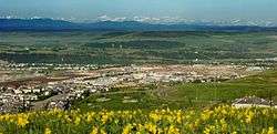
Cochrane /ˈkɒkrən/ is a town in the Canadian province of Alberta. The town is located 18 km (11 mi) west of the Calgary city limits along Highway 1A. With a population of 26,320 in 2017, Cochrane is the second largest town in Alberta and one of the fastest growing communities in Canada. It is part of Calgary's census metropolitan area and a member community of the Calgary Regional Partnership (CRP). The town is surrounded by Rocky View County.
History
Cochrane was established in 1881 as the Cochrane Ranche, after Matthew Henry Cochrane, a local rancher. It became a village in 1903[7] and it had a newspaper and volunteer fire department by 1909.[8] Cochrane incorporated as a town in 1971.[7]
Geography
Cochrane is situated at the base of Big Hill in the Bow River Valley. It sits at an elevation of 1,186 metres (3,891 ft). The town is intersected by Highway 1A and Highway 22. Cochrane has a reputation for its western culture, which can easily be felt when one wanders the streets (particularly Main Street). The town is a popular destination for ice cream and coffee in its quaint western-oriented stores as well as for windsports, golfing, hiking and other adventure activities.
Cochrane is also a small industrial centre. Major industries include lumber, construction, retail, and agriculture (ranching). It is notable as being one of a very few communities in Canada with no business tax.
Cochrane is known for outdoor pursuits. It is a centre for paragliding instruction, with the renowned Nick Mueller family operating a school at the top of the Big Hill.
The hill is also a popular training ground for cyclists from the area, who take advantage of its 7% grade and 3.5 km distance.
Neighbourhoods
The following neighbourhoods are located within Cochrane.[9]
- Bow Meadows
- Bow Ridge
- Cochrane Heights
- Downtown
- East End
- Fireside
- Glenbow
- GlenEagles
- Heartland
- Heritage Hills
- Jumping Pound Ridge
- Riversong
- Riviera
- Riverview
- Sunset Ridge
- The Willows
- West Pointe
- West Terrace
- West Valley
Demographics
| Federal census population history | ||
|---|---|---|
| Year | Pop. | ±% |
| 1901 | 92 | — |
| 1906 | 158 | +71.7% |
| 1911 | 395 | +150.0% |
| 1916 | 284 | −28.1% |
| 1921 | 268 | −5.6% |
| 1926 | 282 | +5.2% |
| 1931 | 293 | +3.9% |
| 1936 | 339 | +15.7% |
| 1941 | 298 | −12.1% |
| 1946 | 405 | +35.9% |
| 1951 | 530 | +30.9% |
| 1956 | 707 | +33.4% |
| 1961 | 857 | +21.2% |
| 1966 | 819 | −4.4% |
| 1971 | 1,046 | +27.7% |
| 1976 | 1,450 | +38.6% |
| 1981 | 3,544 | +144.4% |
| 1986 | 4,190 | +18.2% |
| 1991 | 5,267 | +25.7% |
| 1996 | 7,424 | +41.0% |
| 2001 | 11,798 | +58.9% |
| 2006 | 13,760 | +16.6% |
| 2011 | 17,580 | +27.8% |
| 2016 | 25,853 | +47.1% |
| Source: Statistics Canada [10][11][12][13][14][15][16][17][18][19][20] [21][22][23][24][25][26][27][28][29][30][31][21][3] | ||
The population of the Town of Cochrane according to its 2017 municipal census is 26,320,[32] a change of 4.8% from its 2016 municipal census population of 25,122.[5] At its current population, Cochrane is one of the largest towns in the province and is eligible for city status. According to Alberta's Municipal Government Act, a town is eligible for city status when it reaches 10,000 residents.[33]
In the 2016 Census of Population conducted by Statistics Canada, the Town of Cochrane recorded a population of 25,853 living in 9,757 of its 10,225 total private dwellings, a 47.1% change from its 2011 population of 17,580. With a land area of 29.83 km2 (11.52 sq mi), it had a population density of 866.7/km2 (2,244.7/sq mi) in 2016.[3]
In the 2011 Census, the Town of Cochrane had a population of 17,580 living in 6,523 of its 6,824 total dwellings, a 27.8% change from its 2006 population of 13,760. With a land area of 30.03 km2 (11.59 sq mi), it had a population density of 585.4/km2 (1,516.2/sq mi) in 2011.[21]
Arts and culture
Cochrane Ranche provided the corral setting for the 1954 National Film Board of Canada documentary Corral, by Colin Low, whose father had worked as a foreman at the ranch. This film played theatrically across Canada and was named Best Documentary at the Venice Film Festival.[34]
Cochrane houses attractions such as Cochrane Ranche Historic Site and Bert Sheppard Stockmen's Foundation Library And Archives, located in the Cochrane Ranchehouse.
Cochrane is home to many annual events each year:
- Chamber of Commerce Trade Fair: Early May
- Canada Day (July 1)[35]
- Cochrane and Area Events Society, with support from the Town of Cochrane presents the Canada Day Community Celebration : Canada Day (July 1)[35]
- Labour Day Rodeo & Parade: Labour Day weekend
- Terry Fox Run: September
- Christmas Lightup: Late November
Government
- Municipal politics
Cochrane has a town council consisting of an elected mayor and six councillors elected at-large. Councillors are elected by the eligible electors by voting for up to six candidates and the six receiving the largest number of votes being elected. The position of deputy mayor is rotated through the councillors over their term. Elections are held on the third Monday in October every fourth year.
As of October 16, 2017, the town council consists of Mayor Jeff Genung and Councillors Marni Fedeyko, Susan Flowers, Tara McFadden, Morgan Nagel, Alex Reed, and Patrick Wilson[36].
- Provincial politics
Cochrane is located within the provincial electoral division of Banff-Cochrane. It has been represented in the Alberta Legislature by NDP MLA Cam Westhead since the 2015 provincial election.
- Federal politics
Cochrane is located along the southern most boundary of the federal electoral district of Wild Rose. Blake Richards has represented Cochrane in the House of Commons since 2008. He replaced long standing MP Myron Thompson, who was originally elected as a member of the Reform Party in 1993.
Education
Cochrane is home to schools from the public Rocky View School Division, the separate Calgary Catholic School District, and the Greater Southern Alberta Catholic Francophone Region #4 (CSCFSA).
As of 2008, there were nine public and separate schools in operation within the town boundaries.
- Rocky View School Division
- Cochrane High School: Grades 9–12
- Bow Valley High School: Grades 9–12
- Elizabeth Barret Elementary School: Kindergarten, Grades 1–4
- Glenbow Elementary School: Kindergarten, Grades 1–4
- Mitford School: Kindergarten, Grades 5–8
- Manachaban School: Kindergarten, Grades 5-8
- Cochrane Christian Academy: Kindergarten, Grades 1-8
- Calgary Catholic School District
- Holy Spirit: Kindergarten, Grades 1–8
- St. Timothy: Grades 7–12
- Nôtre Dame Des Vallées: Kindergarten, Grades 1–8 (French-Catholic school GSACFR#4 or CSCFSA)
- Rancheview School: Kindergarten, Grades 1-8
- Fireside School: Kindergarten, Grades 1-7
In November 2006 the Rocky View School Division accepted a proposal by the Cochrane Christ-Centred Education Society to set up a Protestant Christian education program in Cochrane. The Cochrane Christian Academy opened its doors at Mitford Middle School in September 2007, offering kindergarten to grade 4. Approval for expansion to include grade 5 for the 2008–09 school year was given by the board of trustees in April 2008.
There are two trustees (one from each board) elected to represent Cochrane Schools at their respective boards.
The Greater Southern Alberta Catholic Francophone Region #4 has one trustee for the Region from Cochrane.
Cochrane is also home to the Canadian Southern Baptist Seminary, the flagship seminary of the Canadian National Baptist Convention, the Canadian branch of the largest US Protestant denomination.
Notable people
- Rob Cote, professional football player
- Justin Dowling, professional ice hockey player
- George Fox, musician
- Ethan Gage, professional soccer player
- Mason Raymond, professional ice hockey player
See also
References
- ↑ "Location and History Profile: Town of Cochrane" (PDF). Alberta Municipal Affairs. June 17, 2016. p. 162. Retrieved June 19, 2016.
- ↑ "Municipal Officials Search". Alberta Municipal Affairs. September 22, 2017. Retrieved September 25, 2017.
- 1 2 3 4 "Population and dwelling counts, for Canada, provinces and territories, and census subdivisions (municipalities), 2016 and 2011 censuses – 100% data (Alberta)". Statistics Canada. February 8, 2017. Retrieved February 8, 2017.
- ↑ "Alberta Private Sewage Systems 2009 Standard of Practice Handbook: Appendix A.3 Alberta Design Data (A.3.A. Alberta Climate Design Data by Town)" (PDF) (PDF). Safety Codes Council. January 2012. pp. 212–215 (PDF pages 226–229). Retrieved October 8, 2013.
- 1 2 "2016 Municipal Affairs Population List" (PDF). Alberta Municipal Affairs. ISBN 978-1-4601-3127-5. Retrieved January 13, 2018.
- ↑ "Way more than a ton". Cochrane Times. Canoe Sun Media. 2012-09-30. Retrieved 2012-10-06.
- 1 2 "History of Cochrane". Town of Cochrane. Retrieved December 9, 2012.
- ↑ Read, Tracy (1983). Acres and Empires : a history of the Municipal District of Rocky View no. 44. p. 65.
- ↑ "Neighbourhoods | Cochrane, AB - Official Website". www.cochrane.ca. Retrieved 2016-02-05.
- ↑ "Table IX: Population of cities, towns and incorporated villages in 1906 and 1901 as classed in 1906". Census of the Northwest Provinces, 1906. Sessional Paper No. 17a. Ottawa: Government of Canada. 1907. p. 100.
- ↑ "Table I: Area and Population of Canada by Provinces, Districts and Subdistricts in 1911 and Population in 1901". Census of Canada, 1911. Volume I. Ottawa: Government of Canada. 1912. pp. 2–39.
- ↑ "Table I: Population of Manitoba, Saskatchewan, and Alberta by Districts, Townships, Cities, Towns, and Incorporated Villages in 1916, 1911, 1906, and 1901". Census of Prairie Provinces, 1916. Population and Agriculture. Ottawa: Government of Canada. 1918. pp. 77–140.
- ↑ "Table 8: Population by districts and sub-districts according to the Redistribution Act of 1914 and the amending act of 1915, compared for the census years 1921, 1911 and 1901". Census of Canada, 1921. Ottawa: Government of Canada. 1922. pp. 169–215.
- ↑ "Table 7: Population of cities, towns and villages for the province of Alberta in census years 1901-26, as classed in 1926". Census of Prairie Provinces, 1926. Census of Alberta, 1926. Ottawa: Government of Canada. 1927. pp. 565–567.
- ↑ "Table 12: Population of Canada by provinces, counties or census divisions and subdivisions, 1871-1931". Census of Canada, 1931. Ottawa: Government of Canada. 1932. pp. 98–102.
- ↑ "Table 4: Population in incorporated cities, towns and villages, 1901-1936". Census of the Prairie Provinces, 1936. Volume I: Population and Agriculture. Ottawa: Dominion Bureau of Statistics. 1938. pp. 833–836.
- ↑ "Table 10: Population by census subdivisions, 1871–1941". Eighth Census of Canada, 1941. Volume II: Population by Local Subdivisions. Ottawa: Dominion Bureau of Statistics. 1944. pp. 134–141.
- ↑ "Table 6: Population by census subdivisions, 1926-1946". Census of the Prairie Provinces, 1946. Volume I: Population. Ottawa: Dominion Bureau of Statistics. 1949. pp. 401–414.
- ↑ "Table 6: Population by census subdivisions, 1871–1951". Ninth Census of Canada, 1951. Volume I: Population, General Characteristics. Ottawa: Dominion Bureau of Statistics. 1953. p. 6.73–6.83.
- ↑ "Table 6: Population by sex, for census subdivisions, 1956 and 1951". Census of Canada, 1956. Population, Counties and Subdivisions. Ottawa: Dominion Bureau of Statistics. 1957. p. 6.50–6.53.
- 1 2 3 "Population and dwelling counts, for Canada, provinces and territories, and census subdivisions (municipalities), 2011 and 2006 censuses (Alberta)". Statistics Canada. 2012-02-08. Retrieved 2012-02-08.
- ↑ "Table 6: Population by census subdivisions, 1901–1961". 1961 Census of Canada. Series 1.1: Historical, 1901–1961. Volume I: Population. Ottawa: Dominion Bureau of Statistics. 1963. p. 6.77–6.83.
- ↑ "Population by specified age groups and sex, for census subdivisions, 1966". Census of Canada, 1966. Population, Specified Age Groups and Sex for Counties and Census Subdivisions, 1966. Ottawa: Dominion Bureau of Statistics. 1968. p. 6.50–6.53.
- ↑ "Table 2: Population of Census Subdivisions, 1921–1971". 1971 Census of Canada. Volume I: Population, Census Subdivisions (Historical). Ottawa: Statistics Canada. 1973. p. 2.102–2.111.
- ↑ "Table 3: Population for census divisions and subdivisions, 1971 and 1976". 1976 Census of Canada. Census Divisions and Subdivisions, Western Provinces and the Territories. Volume I: Population, Geographic Distributions. Ottawa: Statistics Canada. 1977. p. 3.40–3.43.
- ↑ "Table 4: Population and Total Occupied Dwellings, for Census Divisions and Subdivisions, 1976 and 1981". 1981 Census of Canada. Volume II: Provincial series, Population, Geographic distributions (Alberta). Ottawa: Statistics Canada. 1982. p. 4.1–4.10. ISBN 0-660-51095-2.
- ↑ "Table 2: Census Divisions and Subdivisions – Population and Occupied Private Dwellings, 1981 and 1986". Census Canada 1986. Population and Dwelling Counts – Provinces and Territories (Alberta). Ottawa: Statistics Canada. 1987. p. 2.1–2.10. ISBN 0-660-53463-0.
- ↑ "Table 2: Population and Dwelling Counts, for Census Divisions and Census Subdivisions, 1986 and 1991 – 100% Data". 91 Census. Population and Dwelling Counts – Census Divisions and Census Subdivisions. Ottawa: Statistics Canada. 1992. pp. 100–108. ISBN 0-660-57115-3.
- ↑ "Table 10: Population and Dwelling Counts, for Census Divisions, Census Subdivisions (Municipalities) and Designated Places, 1991 and 1996 Censuses – 100% Data". 96 Census. A National Overview – Population and Dwelling Counts. Ottawa: Statistics Canada. 1997. pp. 136–146. ISBN 0-660-59283-5.
- ↑ "Population and Dwelling Counts, for Canada, Provinces and Territories, and Census Divisions, 2001 and 1996 Censuses - 100% Data (Alberta)". Statistics Canada. Retrieved 2012-04-02.
- ↑ "Population and dwelling counts, for Canada, provinces and territories, and census subdivisions (municipalities), 2006 and 2001 censuses - 100% data (Alberta)". Statistics Canada. 2010-01-06. Retrieved 2012-04-02.
- ↑ "2017 Municipal Affairs Population List" (PDF). Alberta Municipal Affairs. ISBN 978-1-4601-3652-2. Retrieved January 13, 2018.
- ↑ "Municipal Government Act". Alberta Queen's Printer. Retrieved September 5, 2012.
- ↑ "Corral". NFB.ca. National Film Board of Canada. Retrieved 2009-09-01.
- 1 2 "Archived copy". Archived from the original on 2011-07-06. Retrieved 2010-09-09.
- ↑ "Members of Council | Cochrane, AB - Official Website". www.cochrane.ca. Retrieved 2018-05-03.
External links
| Wikivoyage has a travel guide for Cochrane (Alberta). |
Places adjacent to Cochrane, Alberta | ||||||||||
|---|---|---|---|---|---|---|---|---|---|---|
| ||||||||||