Daysland
| Daysland | |
|---|---|
| Town | |
| Town of Daysland | |
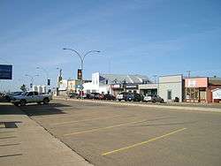 Main Street, Daysland, 2012 | |
 Daysland Location of Daysland in Alberta | |
| Coordinates: 52°51′48″N 112°15′13″W / 52.86333°N 112.25361°W | |
| Country |
|
| Province |
|
| Region | Central Alberta |
| Census division | 7 |
| Municipal district | Flagstaff County |
| Incorporated[1] | |
| • Village | April 23, 1906 |
| • Town | April 2, 1907 |
| Government[2] | |
| • Mayor | Gail Watt |
| • Governing body | Daysland Town Council |
| Area (2016)[3] | |
| • Land | 1.75 km2 (0.68 sq mi) |
| Elevation[4] | 708 m (2,323 ft) |
| Population (2016)[3] | |
| • Total | 824 |
| • Density | 471.1/km2 (1,220/sq mi) |
| Time zone | UTC-7 (MST) |
| Postal code span | T0B 1A0 |
| Highways |
Highway 13 Highway 855 |
| Waterways | Wavy Lake |
| Website | Official website |
Daysland is a town in central Alberta located on Highway 13, 43 kilometres (27 mi) east of Camrose.
History
The community was named for its founder and first mayor, Edgerton W. Day,[5] who purchased 116,483 acres (47,139 ha) of land from the CPR in 1904 to form the basis of Daysland.[6]
Demographics
In the 2016 Census of Population conducted by Statistics Canada, the Town of Daysland recorded a population of 824 living in 330 of its 356 total private dwellings, a 2.1% change from its 2011 population of 807. With a land area of 1.75 km2 (0.68 sq mi), it had a population density of 470.9/km2 (1,219.5/sq mi) in 2016.[3]
In the 2011 Census, the Town of Daysland had a population of 807 living in 329 of its 352 total dwellings, a -1.3% change from its 2006 population of 818. With a land area of 1.75 km2 (0.68 sq mi), it had a population density of 461.1/km2 (1,194.4/sq mi) in 2011.[7]
Notable people
- Richard Petiot, professional hockey player
- Matthew Spiller, professional hockey player
See also
References
- ↑ "Location and History Profile: Town of Daysland" (PDF). Alberta Municipal Affairs. October 7, 2016. p. 183. Retrieved October 16, 2016.
- ↑ "Municipal Officials Search". Alberta Municipal Affairs. September 22, 2017. Retrieved September 25, 2017.
- 1 2 3 "Population and dwelling counts, for Canada, provinces and territories, and census subdivisions (municipalities), 2016 and 2011 censuses – 100% data (Alberta)". Statistics Canada. February 8, 2017. Retrieved February 8, 2017.
- ↑ "Alberta Private Sewage Systems 2009 Standard of Practice Handbook: Appendix A.3 Alberta Design Data (A.3.A. Alberta Climate Design Data by Town)" (PDF) (PDF). Safety Codes Council. January 2012. pp. 212–215 (PDF pages 226–229). Retrieved October 8, 2013.
- ↑ Harrison, Tracey (1994). Place Names of Alberta. Volume III. Central Alberta. Calgary: University of Calgary Press. Retrieved 2011-12-03.
- ↑ Daysland History Book Society (1982). Along the Crocus Trail : a history of Daysland and districts. Friesen & Sons. p. 1.
- ↑ "Population and dwelling counts, for Canada, provinces and territories, and census subdivisions (municipalities), 2011 and 2006 censuses (Alberta)". Statistics Canada. 2012-02-08. Retrieved 2012-02-08.
External links
Coordinates: 52°51′54″N 112°15′13″W / 52.86500°N 112.25361°W