Mundare
| Mundare | |
|---|---|
| Town | |
| Town of Mundare | |
 Mundare | |
| Coordinates: 53°35′28″N 112°20′11″W / 53.59111°N 112.33639°WCoordinates: 53°35′28″N 112°20′11″W / 53.59111°N 112.33639°W | |
| Country |
|
| Province |
|
| Region | Central Alberta |
| Census division | 10 |
| Municipal district | Lamont County |
| Incorporated[1] | |
| • Village | March 6, 1907 |
| • Town | January 4, 1951 |
| Government[2] | |
| • Mayor | Charlie Gargus |
| • Governing body | Mundare Town Council |
| Area (2016)[3] | |
| • Land | 4.21 km2 (1.63 sq mi) |
| Elevation[4] | 678 m (2,224 ft) |
| Population (2016)[3] | |
| • Total | 852 |
| • Density | 202.1/km2 (523/sq mi) |
| Time zone | UTC−7 (MST) |
| • Summer (DST) | UTC−6 (MDT) |
| Area code(s) | -1+780 |
| Highways |
Highway 16 Highway 15 Highway 855 |
| Waterway | Beaverhill Lake |
| Website | Official website |
Mundare is a small town in central Alberta, Canada. It is located 70 km (43 mi) east of Edmonton and 24 km (15 mi) west of Vegreville, at the intersection of Highway 15 and Highway 855, 2 km (1.2 mi) north of the Yellowhead Highway. The Canadian National Railway tracks run through the town.
Beaverhill Lake lies southwest of the town, and Elk Island National Park is located 30 km (19 mi) west of Mundare.
History
-cr.jpg)
Mundare was named after William Mundare, a railway station agent. In July 2007, the town marked its 100th anniversary with a three-day celebration.
Demographics
In the 2016 Census of Population conducted by Statistics Canada, the Town of Mundare recorded a population of 852 living in 359 of its 390 total private dwellings, a −0.4% change from its 2011 population of 855. With a land area of 4.21 km2 (1.63 sq mi), it had a population density of 202.4/km2 (524.1/sq mi) in 2016.[3]
In the 2011 Census, the Town of Mundare had a population of 855 living in 349 of its 387 total dwellings, a 20.1% change from its 2006 population of 712. With a land area of 4.2 km2 (1.6 sq mi), it had a population density of 203.6/km2 (527.2/sq mi) in 2011.[5]
The population of the Town of Mundare according to its 2009 municipal census is 823.[6]
Attractions
Mundare is host to The Basilian Father's Museum that presents the history of the Ukrainian settlement and Basilian Fathers Mission in east-central Alberta. It holds a unique collection of 16th and 17th century liturgical books from Ukraine. The museum is off of the highway 855 that borders the eastern part of town and is across from the "Grotto" called the "Golgotha of Mundare", an elegant garden and shrine that was built by the Basilian Fathers in 1934.
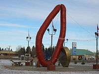
It is also home of the world's largest garlic sausage (kielbasa or kovbasa), which cost about $120,000 to build and erect.[7]
Notable people
- Albert Bandura, psychologist
See also
References
- ↑ "Location and History Profile: Town of Mundare" (PDF). Alberta Municipal Affairs. October 7, 2016. p. 421. Retrieved October 16, 2016.
- ↑ "Municipal Officials Search". Alberta Municipal Affairs. September 22, 2017. Retrieved September 25, 2017.
- 1 2 3 "Population and dwelling counts, for Canada, provinces and territories, and census subdivisions (municipalities), 2016 and 2011 censuses – 100% data (Alberta)". Statistics Canada. February 8, 2017. Retrieved February 8, 2017.
- ↑ "Alberta Private Sewage Systems 2009 Standard of Practice Handbook: Appendix A.3 Alberta Design Data (A.3.A. Alberta Climate Design Data by Town)" (PDF) (PDF). Safety Codes Council. January 2012. pp. 212–215 (PDF pages 226–229). Retrieved October 8, 2013.
- ↑ "Population and dwelling counts, for Canada, provinces and territories, and census subdivisions (municipalities), 2011 and 2006 censuses (Alberta)". Statistics Canada. 2012-02-08. Retrieved 2012-02-08.
- ↑ Alberta Municipal Affairs (2009-09-15). "Alberta 2009 Official Population List" (PDF). Retrieved 2010-09-14.
- ↑ Big Things. Mundare giant Kielbasa
External links
Places adjacent to Mundare | |
|---|---|