Coaldale, Alberta
| Coaldale | ||
|---|---|---|
| Town | ||
| Town of Coaldale | ||
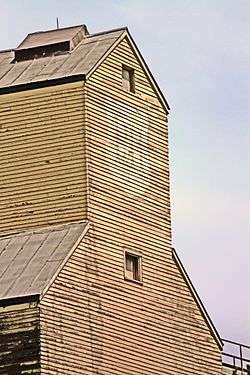 Parrish & Heimbecker elevator along the CPR tracks. | ||
| ||
 Coaldale Location of Coaldale in Alberta | ||
| Coordinates: 49°43′40″N 112°37′06″W / 49.72778°N 112.61833°W | ||
| Country |
| |
| Province |
| |
| Region | Southern Alberta | |
| Census division | 2 | |
| Municipal district | Lethbridge County | |
| Incorporated[1] | ||
| • Village | December 27, 1919 | |
| • Town | January 7, 1952 | |
| Government[2] | ||
| • Mayor | Kim Craig | |
| • Governing body | Coaldale Town Council | |
| Area (2016)[3] | ||
| • Land | 7.99 km2 (3.08 sq mi) | |
| Elevation[4] | 863 m (2,831 ft) | |
| Population (2016)[3] | ||
| • Total | 8,215 | |
| • Density | 1,028.5/km2 (2,664/sq mi) | |
| Time zone | UTC-7 (MST) | |
| Forward sortation area | T1M | |
| Highways |
Highway 3 Highway 845 | |
| Website | Official website | |
Coaldale is a town in southern Alberta, Canada, located 11 km (6.8 mi) east of Lethbridge, along the Crowsnest Highway. Coaldale became a village in 1919 and then became incorporated as a town in 1952.[5]
Demographics
In the 2016 Census of Population conducted by Statistics Canada, the Town of Coaldale recorded a population of 8,215 living in 3,007 of its 3,070 total private dwellings, a 9.6% change from its 2011 population of 7,493. With a land area of 7.99 km2 (3.08 sq mi), it had a population density of 1,028.2/km2 (2,662.9/sq mi) in 2016.[3]
The Town of Coaldale's 2013 municipal census counted a population of 7,526,[6] an 8.4% increase over its 2009 municipal census population of 6,943.[7]
In the 2011 Census, the Town of Coaldale had a population of 7,493 living in 2,751 of its 2,844 total dwellings, a 21.3% change from its 2006 population of 6,177. With a land area of 7.95 km2 (3.07 sq mi), it had a population density of 942.5/km2 (2,441.1/sq mi) in 2011.[8]
Attractions
The main attractions are the Alberta Birds of Prey Centre,[9] the Land o' Lakes Golf Course, and the Gem of the West Museum.[10]
Chin Lakes are located 20 minutes east of Coaldale, and offers such recreational services as waterskiing and campfire pits. The Indian Hills Golf Course is another golf course, 9 holes, and is approximately 15 minutes south-west of Coaldale. Across the road is a small campground and a lake, which is commonly regarded as an ideal place for fishing.
McCain Foods has a processing plant in Coaldale, which was opened in 2000.
Stafford Lake is located approximately 10 minutes east of the town.
The Coaldale Copperheads playing out of the Heritage Junior Hockey League call the Sportsplex (The SnakePit) home and have one of the best attended home crowds in the HJHL. They relocated from Lethbridge in 2007.
Notable people
- B. B. Janz, Mennonite minister[11]
- Joy Kogawa, Canadian author
- Kyle McLaren, NHL hockey player
- Theo Tams, Canadian Idol winner
- Rudy Wiebe, Canadian author
See also
References
- ↑ "Location and History Profile: Town of Coaldale" (PDF). Alberta Municipal Affairs. June 17, 2016. p. 148. Retrieved June 20, 2016.
- ↑ Alberta Municipal Affairs: Municipal Officials Search
- 1 2 3 "Population and dwelling counts, for Canada, provinces and territories, and census subdivisions (municipalities), 2016 and 2011 censuses – 100% data (Alberta)". Statistics Canada. February 8, 2017. Retrieved February 8, 2017.
- ↑ "Alberta Private Sewage Systems 2009 Standard of Practice Handbook: Appendix A.3 Alberta Design Data (A.3.A. Alberta Climate Design Data by Town)" (PDF) (PDF). Safety Codes Council. January 2012. pp. 212–215 (PDF pages 226–229). Retrieved October 8, 2013.
- ↑ Coaldale Historical Society (1983). Coaldale : gem of the west, 1900-1983. Coaldale, Alberta. p. 1. ISBN 0-88925-255-6.
- ↑ "2013 Census Information". Town of Coaldale. Retrieved August 19, 2013.
- ↑ "Alberta 2009 Official Population List" (PDF). Alberta Municipal Affairs. September 15, 2009. Retrieved September 14, 2010.
- ↑ "Population and dwelling counts, for Canada, provinces and territories, and census subdivisions (municipalities), 2011 and 2006 censuses (Alberta)". Statistics Canada. 2012-02-08. Retrieved 2012-02-08.
- ↑ Alberta Birds of Prey Centre
- ↑ Gem of the West Museum
- ↑ Wiebe, Katie Funk and Richard D. Thiessen (2005). "Janz, Benjamin B. (1877-1964)". Global Anabaptist Mennonite Encyclopedia Online. Retrieved 2008-07-31.
External links
| Wikimedia Commons has media related to Coaldale, Alberta. |
Places adjacent to Coaldale, Alberta | |
|---|---|