Dnieper
| Dnieper | |
| Russian: Днепр (Dnepr) Belarusian: Дняпро/Днепр (Dnyapro/Dnepr) Ukrainian: Дніпро (Dnipro) Ancient Greek: Βορυσθένης (Borysthenes) | |
| River | |
 | |
| Countries | Russia, Belarus, Ukraine |
|---|---|
| Tributaries | |
| - left | Sozh, Desna, Trubizh, Supiy, Sula, Psel, Vorskla, Samara, Konka, Bilozerka |
| - right | Drut, Berezina, Prypiat, Teteriv, Irpin, Stuhna, Ros, Tiasmyn, Bazavluk, Inhulets |
| Cities | Dorogobuzh, Smolensk, Mogilev, Kiev, Cherkasy, Dnipro, Zaporizhia |
| Source | |
| - location | Valdai Hills, Russia |
| - elevation | 220 m (722 ft) |
| - coordinates | 55°52′00″N 33°41′00″E / 55.86667°N 33.68333°E |
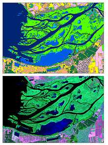
| Mouth | Dnieper Delta |
| - elevation | 0 m (0 ft) |
| - coordinates | 46°30′00″N 32°20′00″E / 46.50000°N 32.33333°ECoordinates: 46°30′00″N 32°20′00″E / 46.50000°N 32.33333°E |
| Length | 2,201 km (1,368 mi) |
| Basin | 504,000 km2 (194,595 sq mi) |
| Discharge | for Kherson |
| - average | 1,670 m3/s (58,975 cu ft/s) |
| Protection status | |
| Official name | Dnieper River Floodplain |
| Designated | 29 May 2014 |
| Reference no. | 2244[1] |
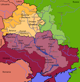 Dnieper River drainage basin | |
The Dnieper River (UK: /ˈdniːpər/,[2] US: /ˈniːpər/[3]; Russian: Днепр, translit. Dnepr, /ˈdnjɛpər/;[4] Belarusian: Дняпро/Днепр, translit. Dnyapro/Dnepr; Ukrainian: Днiпро, translit. Dnipro, /ˈ(d)niːproʊ/;[5]) is one of the major rivers of Europe, rising in the Valdai Hills near Smolensk, Russia, and flowing through Russia, Belarus and Ukraine to the Black Sea. It is the longest river of Ukraine and Belarus and the fourth-longest river in Europe. The total length is approximately 2,200 km (1,400 mi)[6] with a drainage basin of 504,000 square kilometres (195,000 sq mi). The river is noted for its dams and hydroelectric stations. The Dnieper is an important navigable waterway for the economy of Ukraine and is connected via the Dnieper–Bug Canal to other waterways in Europe.
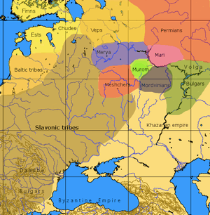
In antiquity, the river was known to the Greeks as the Borysthenes and was part of the Amber Road. Arheimar, a capital of the Goths, was located on the Dnieper, according to the Hervarar saga.
Etymology and name in various languages
The name Dnieper may be derived either from Sarmatian Dānu apara "the river on the far side" or from Scythian Dānu apr (Dānapr) "deep river." By way of contrast, the name Dniester either derives from "the close river" or from a combination of Scythian Dānu (river) and Ister, the Thracian name for the Dniester.[7] [8] Perhaps the name Dnieper (ancient Danapris) is derived from Turkic Dynporis (from Turkic tyn "quiet" and boris "winding").[9]
In the three countries through which it flows it has essentially the same name, albeit pronounced differently:
- Russian: Днепр (Dnepr, [dnʲepr]);
- Belarusian: Дняпро (Dnyapro, [dnʲaˈprɔ]) or Днепр[10] (Dnyepr, [dnʲɛpr]);
- Ukrainian: Дніпро (Dnipro, [dnʲiˈprɔ]) or Дніпер[11] (Dniper, [ˈdnʲiper]).
The late Greek and Roman authors called it Δάναπρις - Danapris and Danaper respectively. Its Old East Slavic name used at the time of Kievan Rus' was Slavuta or Slavutych, the Huns called it Var,[12] and Bulgars - Buri-Chai. The name in Crimean Tatar: Özü.[13] The river is mentioned both by the Ancient Greek historian Herodotus in the 5th century BC as Borysthenes (Βορυσθένης), as well as by Strabo; this name is Scythian (cf. Iranian *varu-stāna) and translates as "wide land", referring most likely to the Ukrainian steppe. .
Geography
The total length of the river is variously given as 2,145 kilometres (1,333 mi)[6] or 2,201 km (1,368 mi),[14][15][16][17] of which 485 km (301 mi) are within Russia, 700 km (430 mi) are within Belarus,[6] and 1,095 km (680 mi) are within Ukraine. Its basin covers 504,000 square kilometres (195,000 sq mi), of which 289,000 km2 (112,000 sq mi) are within Ukraine,[18] 118,360 km2 (45,700 sq mi) are within Belarus.[6]
The source of the Dnieper is the sedge bogs (Akseninsky Mokh) of the Valdai Hills in central Russia, at an elevation of 220 m (720 ft).[18] For 115 km (71 mi) of its length, it serves as the border between Belarus and Ukraine. Its estuary, or liman, used to be defended by the strong fortress of Ochakiv.
On the Dnepr River to the south of Komarin urban-type settlement, Braghin District, Gomel Region the southern extreme point of Belarus is situated.[19]
Tributaries of the Dnieper
The Dnieper has many tributaries (up to 32,000) with 89 being rivers of 100+ km.[20] The main ones are, from its source to its mouth:
Many small direct tributaries also exist, such as, in the Kiev area, the Syrets (right bank) in the north of the city, the historically significant Lybid (right bank) passing west of the centre, and the Borshahivka (right bank) to the south.
The water resources of the Dnieper basin compose around 80% out of all Ukraine.[20]
Rapids
Dnieper Rapids were part of trade route from the Varangians to the Greeks, first mentioned in the Kiev Chronicle. The route was probably established in the late eighth and early ninth centuries and gained significant importance from the tenth until the first third of the eleventh century. On the Dnieper the Varangians had to portage their ships round seven rapids, where they had to be on guard for Pecheneg nomads.
Along this middle flow of the Dnieper, there were nine major rapids (although some sources cite a fewer number of them), obstructing almost the whole width of the river, about 30–40 smaller rapids, obstructing only part of the river, and about 60 islands and islets.
After Dnieper Hydroelectric Station was built in 1932, they were inundated by Dnieper Reservoir.
Canals
There are a number of canals connected to the Dnieper:
- The Dnieper–Donbas Canal;
- The Dnieper–Kryvyi Rih Canal;
- The Kakhovka Canal (south-east of the Kherson region);
- The Krasnoznamianka Irrigation System in the south-west of the Kherson region;
- The North Crimean Canal—will largely solve the water problem of the peninsula, especially in the arid northern and eastern Crimea;
- The Inhulets Irrigation System.
Fauna
The river is part of the Quagga mussel's native range.[21] The mussel has been accidentally introduced around the world where it has become an invasive species.[21]
Reservoirs and hydroelectric power
From the mouth of the Prypiat River to the Kakhovka Hydroelectric Station, there are six sets of dams and hydroelectric stations, which produce 10% of Ukraine's electricity.[20]
The first constructed was the Dnieper Hydroelectric Station (or DniproHES) near Zaporizhia, built in 1927–1932 with an output of 558 MW.[22] It was destroyed during World War II, but was rebuilt in 1948 with an output of 750 MW.
| Location | Dam | Reservoir area | Hydroelection station | Date of construction |
|---|---|---|---|---|
| Kiev | Kiev Reservoir | 922 km2 or 356 sq mi | Kiev Hydroelectric Station | 1960–1964 |
| Kaniv | Kaniv Reservoir | 675 km2 or 261 sq mi | Kaniv Hydroelectric Station | 1963–1975 |
| Kremenchuk | Kremenchuk Reservoir | 2,250 km2 or 870 sq mi | Kremenchuk Hydroelectric Station | 1954–1960 |
| Kamianske | Kamianske Reservoir | 567 km2 or 219 sq mi | Middle Dnieper Hydroelectric Power Plant | 1956–1964 |
| Zaporizhia | Dnieper Reservoir | 420 km2 or 160 sq mi | Dnieper Hydroelectric Station | 1927–1932; 1948 |
| Kakhovka | Kakhovka Reservoir | 2,155 km2 or 832 sq mi | Kakhovka Hydroelectric Station | 1950–1956 |
Regions and cities

Regions
|
|
|
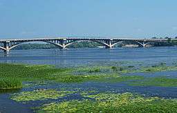
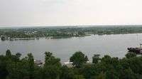
- The Dnieper River in different regions
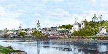 The Dnieper River in Dorogobuzh, Russian Empire, before 1917
 The Dnieper River in Kremenchuk, Ukraine
Cities
Major cities, over 100,000 in population, are in bold script. Cities and towns located on the Dnieper are listed in order from the river's source (in Russia) to its mouth (in Ukraine):
|
Arheimar, a capital of the Goths, was located on the Dnieper, according to the Hervarar saga.[23]
Navigation
Almost 2,000 km (1,200 mi) of the river is navigational (to the city of Dorogobuzh).[20] The Dnieper is important for the transport and economy of Ukraine: its reservoirs have large ship locks, allowing vessels of up to 270 by 18 metres (886 ft × 59 ft) to access as far as the port of Kiev and thus create an important transport corridor. The river is used by passenger vessels as well. Inland cruises on the rivers Danube and Dnieper have been a growing market in recent decades.
Upstream from Kiev, the Dnieper receives the water of the Pripyat River. This navigable river connects to the Dnieper-Bug canal, the link with the Bug River. Historically, a connection with the Western European waterways was possible, but a weir without any ship lock near the town of Brest, Belarus, has interrupted this international waterway. Poor political relations between Western Europe and Belarus mean there is little likelihood of reopening this waterway in the near future.[24] River navigation is interrupted each year by freezing in winter, and severe winter storms.
In the arts
Literature
The River Dnieper has been a subject of chapter X of a story by Nikolai Gogol A Terrible Vengeance (1831, published in 1832 as a part of the Evenings on a Farm Near Dikanka short stories collection). It is considered as a classical example of description of the nature in Russian literature. The river was also described in the works of Taras Shevchenko.
Visual arts
The River Dnieper has been a subject for artists, great and minor, over the centuries. Major artists with works based on the Dnieper are Arkhip Kuindzhi and Ivan Aivazovsky.
- The Dnieper in painting
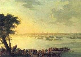 Catherine II leaving Kaniów in 1787 by Johann Gottlieb Plersch
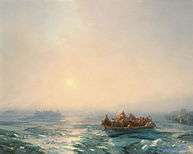 Ice in the Dnepr by Ivan Aivazovsky, 1872
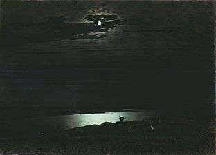 Moonlit Night on the Dniepr by Arkhip Kuindzhi, 1882
 Dniepr by Arkhip Kuindzhi, 1881
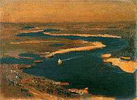 Sapphire Dnieper by Jan Stanisławski, 1904
Popular culture
- The river is one of the symbols of the Ukrainian nation[25] and is mentioned in the national anthem of Ukraine.
- There are several names that connect the name of the river with Ukraine: Overdnieper Ukraine, Right-bank Ukraine, Left-bank Ukraine, and others. Some of the cities on its banks — Dnipro, Dniprorudne, Kamianka-Dniprovska — are named after the river.
- The Zaporozhian Cossacks lived on the lower Dniepr and their name refers to their location "beyond the rapids".[26]
- The river is referred to as Dnipro, in the song "Hey, Dnipro, Dnipro".[27]
- The folk metal band Turisas have a song called "The Dnieper Rapids" on their 2007 album The Varangian Way.[28]
- Leon Bolier featured a track called "Dnipro" in his debut 2-CD album Pictures. The track is said to be inspired by his visit to Kiev in May 2008.
- Briefly mentioned in the science fiction/adventure novel The Crisis Pendant by Charlie Patterson.
- Roberto Bolaño's novel 2666 features the Dnieper as a significant feature of the village of Hans Reiter.
- Beat laureate Spencer Hash spent childhood summers observing tide patterns in the Dnieper. It provides the backdrop for most of his 1998 novel Embassy.
Ecology
Nowadays the Dnieper River suffer from anthropogenic influence and obtain numerous emissions of pollutants.[29] The Dnieper is close to the Prydniprovsky Chemical Plant radioactive dumps (near Kamianske), and susceptible to leakages of radioactive waste. The river is also close to the Chernobyl Nuclear Power Station (Chernobyl Exclusion Zone) that is located next to the mouth of the Prypiat River.
See also
References and footnotes
- ↑ "Dnieper River Floodplain". Ramsar Sites Information Service. Retrieved 25 April 2018.
- ↑ "Dnieper | Definition of Dnieper in English by Oxford Dictionaries". Oxford Dictionaries | English. Retrieved 2018-07-25.
- ↑ "Definition of DNIEPER". www.merriam-webster.com. Retrieved 2018-07-25.
- ↑ "Dnepr definition and meaning | Collins English Dictionary". www.collinsdictionary.com. Retrieved 2018-07-25.
- ↑ "Dnipro | Definition of Dnipro in US English by Oxford Dictionaries". Oxford Dictionaries | English. Retrieved 2018-07-25.
- 1 2 3 4 "Main Geographic Characteristics of the Republic of Belarus. Main characteristics of the largest rivers of Belarus". Land of Ancestors. Data of the Ministry of Natural Resources and Environmental Protection of the Republic of Belarus. 2011. Retrieved 27 September 2013.
- ↑ Mallory, J.P. and Victor H. Mair. The Tarim Mummies: Ancient China and the Mystery of the Earliest Peoples from the West. London: Thames and Hudson, 2000. p. 106
- ↑ Абаев В. И. Осетинский язык и фольклор (Ossetian language and folklore). Moscow: Publishing house of Soviet Academy of Sciences, 1949. p. 236
- ↑ Будагов, Б. А.; Гейбуллаев, Г. А. (1988). "Вопросы тюркской этнонимии в трудах М. З. Закиева". Известия Академии наук Азербайджанской ССР. Серия наук о Земле. 3: 128.
- ↑ Блакітная кніга Беларусі: Энцыклапедыя. — Мінск: Беларуская Энцыклапедыя, 1994. — С. 144. — 415 с. — 10 000 экз.
- ↑ Словарь української мови / Упор. з дод. влас. матеріалу Б. Грінченко : в 4-х т. — К. : Вид-во Академії наук Української РСР, 1958. Том 1, ст. 394.
- ↑ Jordanes, Getica 269.
- ↑ crh:Özü özeni
- ↑ Zastavnyi, F.D. Physical Geography of Ukraine. Rivers of Ukraine. Dnieper. Kiev: "Forum", 2000
- ↑ Masliak, P., Shyshchenko, P. Geography of Ukraine. Kiev: "Zodiak-eko", 1998
- ↑ Website about Dnieper
- ↑ Mishyna, Liliana. Hydrographic research of Dnieper river Archived 2016-03-04 at the Wayback Machine.. Derzhhidrohrafiya.
- 1 2 Kubiyovych, Volodymyr; Ivan Teslia. "Dnieper River". Encyclopedia of Ukraine. Retrieved January 19, 2007.
- ↑ "Main Geographic Characteristics of the Republic of Belarus. Coordinates of the extreme points of the state frontier". Land of Ancestors. The Scientific and Production State Republican Unitary Enterprise "National Cadastre Agency" of the State Property Committee of the Republic of Belarus. 2011. Retrieved 20 September 2013.
- 1 2 3 4 Splendid Dnieper. There is no straighter river. Ukrinform. 4 July 2015
- 1 2 Benson, AJ. "Dreissena rostriformis bugensis Andrusov, 1897". Nonindigenous Aquatic Species. United States Geological Survey. Retrieved 2 May 2014.
- ↑ Edward A. Hewett, Victor H. Winston (1991). Milestones in Glasnost and Perestroyka: Politics and people. Brookings Institution. p. 19. ISBN 9780815736240.
The importance of Chernobyl' for Soviet industry is best illustrated by comparing it to the key energy project of Stalin's industrialization, the famous Dnieper hydroelectric station, completed in 1932. The largest European hydroelectric station of its time, it had a capacity of 560 MW.
- ↑ "An English translation of Hervar saga by Kershaw". Archived from the original on 2006-03-28. Retrieved 2006-03-28.
- ↑ NoorderSoft Waterways Database Archived November 9, 2005, at the Wayback Machine.
- ↑ Work on the subject Ukrainian national symbols. Library of Ukrainian literature.
- ↑ "...the Zaporohjans whose name meant 'those who live beyond the cataracts'...", Henryk Sienkiewicz, With Fire and Sword, chap. 7.
- ↑ Hey, Dnipro, Dnipro on YouTube
- ↑ Releases | Turisas: The Official Battleground
- ↑ V. Snytko, V. Shirokova, N. Ozerova, O. Romanova, A. Sobisevich Hydrological situation of the Upper Dnieper // GeoConference SGEM. — 2017. — Vol. 17, no. 31. — P. 379–384.
External links
- Volodymyr Kubijovyč, Ivan Teslia, Dnieper River at the Encyclopedia of Ukraine
- Site about Dnieper—objects over the river, photos, facts
- Dnieper river charts
- "Комсомольская правда" об угрозах плотины Киевской ГЭС и водохранилища
- "Аргументы и факты" о реальных угрозах дамбы Киевского водохранилища и ГЭС
- "Известия" о проблематике плотины Киевского водохранилища и ГЭС
- Эксперт УНИАН об угрозах дамбы Киевского водохранилища
| Tributaries1 | | |
|---|---|---|
| Reservoirs | ||
| Hydroelectric stations | ||
| Canals |
| |
| Cities | ||
| Crossings | ||
| ||