Hola Prystan
| Hola Prystan Гола Пристань | |||
|---|---|---|---|
| City | |||
 | |||
| |||
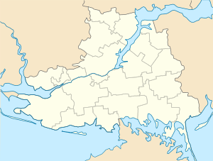 Location of Hola Prystan | |||
| Coordinates: 46°31′N 32°31′E / 46.517°N 32.517°E | |||
| Country |
| ||
| Oblast | Kherson Oblast | ||
| Area | |||
| • Total | 9 km2 (3 sq mi) | ||
| Population (2015) | |||
| • Total | 14,658 | ||
| Postal code | 75600 | ||
| Area code(s) | +380-5539 | ||
| Climate | Cfa | ||
| Website | http://www.golapristan-mrada.gov.ua/ | ||
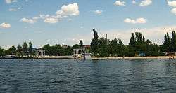
Hola Prystan (Ukrainian: Гола Пристань, Russian: Голая Пристань) is a city in Kherson Oblast (province) of Ukraine. It serves as the administrative center of Hola Prystan Raion. It is administratively incorporated as a city of oblast significance and does not belong to the raion. Population: 14,658 (2015 est.)[1]
The Konka River, a tributary of the Dnieper River, flows through the city.
History
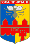
Hola Prystan literally means barren pier and was founded in 1709 by Zaporizhian Cossacks as Holyi Pereviz (Barren Ford). Since 1785 it is first mentioned as Hola Prystan.
In the years of the Ukrainian Independence
Hola Pristan was granted the regional town status on May 17, 2013.
Gallery
 Saint Volodymyr's Church in Hola Prystan
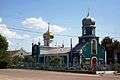 Church of the Holy Spirit in Hola Prystan
References
- ↑ "Чисельність наявного населення України (Actual population of Ukraine)" (PDF) (in Ukrainian). State Statistics Service of Ukraine. Retrieved 1 July 2016.
External links
- The murder of the Jews of Hola Prystan during World War II, at Yad Vashem website.
| Raions | |||||
|---|---|---|---|---|---|
| Cities |
| ||||
| |||||
Coordinates: 46°31′N 32°31′E / 46.517°N 32.517°E
This article is issued from
Wikipedia.
The text is licensed under Creative Commons - Attribution - Sharealike.
Additional terms may apply for the media files.