Dniester
| Dnister[1] | |
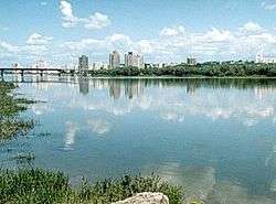 Rîbnița and the Dnister river | |
| Countries | Ukraine, Moldova |
|---|---|
| Tributaries | |
| - left | Murafa River, Smotrych River, Zbruch River, Seret River, Strypa River, Zolota Lypa River, Stryi River |
| - right | Botna River, Bîc River, Răut River, Svicha, Lomnytsia, Ichel |
| Cities | Tiraspol, Bender, Rîbnița, Drohobych |
| Source | |
| - location | Ukrainian Carpathians |
| - elevation | 900 m (2,953 ft) |
| - coordinates | 49°12′44″N 22°55′40″E / 49.21222°N 22.92778°E |
| Mouth | Black Sea |
| - location | Odessa Oblast |
| - elevation | 0 m (0 ft) |
| - coordinates | 46°21′0″N 30°14′0″E / 46.35000°N 30.23333°ECoordinates: 46°21′0″N 30°14′0″E / 46.35000°N 30.23333°E |
| Length | 1,362 km (846 mi) |
| Basin | 68,627 km2 (26,497 sq mi) |
| Discharge | |
| - average | 310 m3/s (10,948 cu ft/s) |
| Designation | |
| Official name | Lower Dnister |
| Designated | 20 August 2003 |
| Reference no. | 1316[2] |
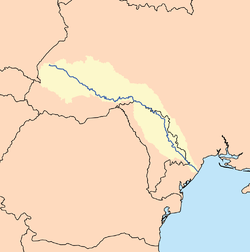 Map of the Dnister basin | |
The Dnister or Dniester River (/ˈniːstər/ NEES-tər[3]) is a river in Eastern Europe. It runs first through Ukraine and then through Moldova (from which it separates the breakaway territory of Transnistria), finally discharging into the Black Sea on Ukrainian territory again.
Names
The name Dnister derives from Sarmatian dānu nazdya "the close river."[4] The Dnipro, also of Sarmatian origin, derives from the opposite meaning, "the river on the far side". Alternatively, according to Vasily Abaev Dnister would be a blend of Scythian dānu "river" and Thracian Ister, the previous name of the river, literally Dān-Ister (River Ister).[5] The Ancient Greek name of Dnister, Tyras (Τύρας), is from Scythian tūra, meaning "rapid." The names of the Don and Danube are also from the same Indo-Iranian word *dānu "river". Classical authors have also referred to it as Danaster. These early forms, without -i- but with -a-, contradict Abaev's hypothesis. Edward Gibbon refers to the river both as the Niester and Dnister in his History of the Decline and Fall of the Roman Empire.[6]
In Ukrainian, it is known as Дністе́р (translit. Dnister), and in Romanian as Nistru. In Russian, it is known as Днестр (translit. Dnestr), in Yiddish: Nester נעסטער; in Turkish, Turla.
Geography
The Dnister rises in Ukraine, near the city of Drohobych, close to the border with Poland, and flows toward the Black Sea. Its course marks part of the border of Ukraine and Moldova, after which it flows through Moldova for 398 kilometres (247 mi), separating the main territory of Moldova from its breakaway region Transnistria. It later forms an additional part of the Moldova-Ukraine border, then flows through Ukraine to the Black Sea, where its estuary forms the Dnister Liman.
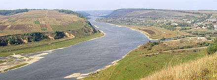
Along the lower half of the Dnister, the western bank is high and hilly while the eastern one is low and flat. The river represents the de facto end of the Eurasian Steppe. Its most important tributaries are Răut and Bîc.
History
During the Neolithic, the Dnister River was the centre of one of the most advanced civilizations on earth at the time. The Cucuteni-Trypillian culture flourished in this area from roughly 5300 to 2600 BC, leaving behind thousands of archeological sites. Their settlements had up to 15,000 inhabitants, making them among the first large farming communities in the world.[7]
In antiquity, the river was considered one of the principal rivers of European Sarmatia, and it was mentioned by many Classical geographers and historians. According to Herodotus (iv.51) it rose in a large lake, whilst Ptolemy (iii.5.17, 8.1 &c.) places its sources in Mount Carpates (the modern Carpathian Mountains), and Strabo (ii) says that they are unknown. It ran in an easterly direction parallel with the Ister (lower Danube), and formed part of the boundary between Dacia and Sarmatia. It fell into the Pontus Euxinus to the northeast of the mouth of the Ister, the distance between them being 900 stadia – approximately 210 km (130 mi) – according to Strabo (vii.), while 210 km (130 mi) (from the Pseudostoma) according to Pliny (iv. 12. s. 26). Scymnus (Fr. 51) describes it as of easy navigation, and abounding in fish. Ovid (ex Pont. iv.10.50) speaks of its rapid course.
Greek authors referred to the river as Tyras (Greek: ὁ Τύρας).[8] At a later period it obtained the name of Danastris or Danastus,[9] whence its modern name of Dnister (Neister), though the Turks still called it Turla during the 19th century.[10] The form Τύρις is sometimes found.[11]
According to Constantine VII, the Varangians used boats on their trade route from the Varangians to the Greeks, along Dnister and Dniper and along the Black Sea shore. The navigation near the western shore of Black Sea contained stops at Aspron (at the mouth of Dnister), then Conopa, Constantia (localities today in Romania) and Messembria (today in Bulgaria).
From the 14th century to 1812, part of the Dnister formed the eastern boundary of the Principality of Moldavia.
Between the World Wars, the Dnister formed part of the boundary between Romania and the Soviet Union. In 1919, on Easter Sunday, the bridge was blown up by the French Army to protect Bender from the Bolsheviks.[12] During World War II, German and Romanian forces battled Soviet troops on the western bank of the river.
After the Republic of Moldova declared its independence in 1991, the small area to the east of the Dnister that had been part of the Moldavian SSR refused to participate and declared itself the Pridnestrovian Moldavian Republic, or Transnistria, with its capital at Tiraspol on the river.
Tributaries
From source to mouth, right tributaries, i.e. on the southwest side, are the Stryi (231 km), Svicha (107 km), Lomnytsia (122 km), Bystrytsia (101 km), Răut (283 km), Ichel (101 km), Bîc (155 km), and Botna (152 km).
Left tributaries, on the northeast side, are the Strv'yazh (94 km), Hnyla Lypa (87 km), Zolota Lypa (140 km), Koropets (78 km), Strypa (147 km), Seret (250 km), Zbruch (245 km), Smotrych (169 km), Ushytsia (122 km), Zhvanchyk (107 km), Liadova (93 km), Murafa (162 km), Rusava (78 km), Yahorlyk (73 km), and Kuchurhan (123 km).[13]
See also
References
- ↑ http://www.encyclopediaofukraine.com/display.asp?linkpath=pages%5cD%5cN%5cDnisterRiver.htm
- ↑ "Lower Dnister". Ramsar Sites Information Service. Retrieved 25 April 2018.
- ↑ Merriam-Webster Dictionary: "Dnister"
- ↑ Mallory, J.P. and Victor H. Mair. The Tarim Mummies: Ancient China and the Mystery of the Earliest Peoples from the West. London: Thames & Hudson, 2000. p. 106
- ↑ Абаев В. И. Осетинский язык и фольклор (Ossetian language and folklore). Moscow: Publishing house of Soviet Academy of Sciences, 1949. P. 236
- ↑ Edward Gibbons Decline and Fall of the Roman Empire Vol 1 chapt 11
- ↑ Mikhail Widejko. "Trypillya Culture Proto-Cities: History of Discovery and Investigations M. Yu. Videiko Published: Відейко М. Ю. Трипільські протоміста. Історія досліджень. Київ 2002; с. 103–125 (Videiko M. Yu. Trypillya culture proto-cities. History of investigations. Kiev 2002, p. 103–125)". Iananu.kiev.ua. Retrieved 2012-08-23.
- ↑ Strab. ii.
- ↑ Amm. Marc. xxxi. 3. § 3; Jornand. Get. 5; Const. Porphyr. de Adm. Imp. 8
- ↑ Herod. iv. 11, 47, 82; Scylax, p. 29; Strab. i. p. 14; Mela, ii. 1, etc.; also Schaffarik, Slav. Alterth. i. p. 505.
- ↑ Stephanus of Byzantium, p. 671; Suid. s. v.
- ↑ Kaba, John (1919). Politico-economic Review of Basarabia. United States: American Relief Administration. p. 15.
- ↑ Encyclopedia of Ukraine – Dnister River
General

External links
| Wikimedia Commons has media related to Dniester. |