Dnieper Reservoir
| Dnieper Reservoir | |
|---|---|
 | |
| Location | Zaporizhzhia (to the south), Dnipro (to the north), Dnipropetrovsk and Zaporizhzhia Oblasts |
| Coordinates | 48°08′09″N 35°07′43″E / 48.13583°N 35.12861°ECoordinates: 48°08′09″N 35°07′43″E / 48.13583°N 35.12861°E |
| Type | Hydroelectric reservoir |
| Primary inflows | Dnieper River |
| Primary outflows | Dnieper River |
| Basin countries | Ukraine |
| Max. length | 129 km (80 mi) |
| Average depth | 8 m (26 ft) |
| Max. depth | 53 m (174 ft) |
| Water volume | 3.3 km3 (2,700,000 acre⋅ft) |
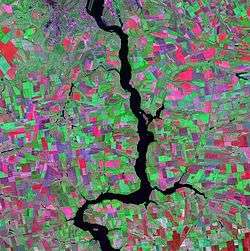
The Dnieper Reservoir (Ukrainian: Дніпровське водосховище, Dniprovs'ke vodoskhovyshche) is a water reservoir on, and named after the Dnieper River in Ukraine. It is located within the Dnipropetrovsk and Zaporizhzhia Oblasts. It was created in 1932 by the construction of the Dnieper Hydroelectric Station.
The reservoir is 129 km long, has an average width of 3.2 km (7 km at its widest), and has an average depth of 8 meters (53 m at its deepest). The total water volume is 3.3 km³.
The Lenin Lake, stretching for approximately ten kilometres at the mouth of the Samara River, flows into the northern end of the reservoir. The creation of the reservoir inundated the historic Dnieper Rapids.
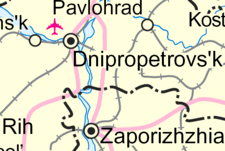
Map of the Dnieper Reservoir.
| Tributaries1 | 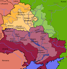 | |
|---|---|---|
| Reservoirs | ||
| Hydroelectric stations | ||
| Canals |
| |
| Cities | ||
| Crossings | ||
| ||
This article is issued from
Wikipedia.
The text is licensed under Creative Commons - Attribution - Sharealike.
Additional terms may apply for the media files.