Marhanets
Coordinates: 47°38′23″N 34°38′11″E / 47.63972°N 34.63639°E
| Marhanets Марганець | |||
|---|---|---|---|
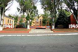 World War II partisan memorial in Marhanets | |||
| |||
 Marhanets Location in Ukraine | |||
| Coordinates: 47°38′41″N 34°36′15″E / 47.64472°N 34.60417°E | |||
| Country |
| ||
| Oblast | Dnipropetrovsk | ||
| Founded | 1938 | ||
| Government | |||
| • Mayor (interim) | Oleksandr Bilyj | ||
| Area | |||
| • Total | 37 km2 (14 sq mi) | ||
| Elevation | 30 m (100 ft) | ||
| Population (2014) | |||
| • Total | 48,345 | ||
| • Density | 1,312/km2 (3,400/sq mi) | ||
| Time zone | UTC+2 (EET) | ||
| • Summer (DST) | UTC+3 (EEST) | ||
| Area code(s) | +380-5665 | ||
| Website | https://web.archive.org/web/20150419154004/http://marganets-rada.dp.ua/index.html | ||


Marhanets (Ukrainian: Марганець, pronounced [ˈmɑrɦɑnɛtsʲ]; Russian: Марганец, pronounced [ˈmarɡənʲɪts], literally manganese) is a city of Dnipropetrovsk Oblast that was established in 1938 in central Ukraine. It was established in place of village Horodyshche that contained a manganese mine (mining town) and in 1926-1938 was called Komintern.
Administratively, it is incorporated within Marhanets municipality as a city of oblast significance which is located on the administrative border between Nikopol and Tomakivka raions. It is located on the right bank of the Kakhovka Reservoir on the Dnieper River where the river meets one of its tributaries Tomakivka. Its population is approximately 47,747 (2017 est.)[1].
It considered that next to the modern city was located the Cossack Fort "Tomakivka Sich" in the 16th century that was destroyed by Tatars soon after the Kosiński Uprising.
2010 accident
On October 12, 2010, at least 42 people died after a road accident in this city.
References
- ↑ "Чисельність наявного населення України (Actual population of Ukraine)" (in Ukrainian). State Statistics Service of Ukraine. Retrieved 26 August 2017.
External links
| Cities | ||
|---|---|---|
| Urban-type settlements | Maryivka | |
| Rural settlements | Maksymivka | |
| Raions | |||||
|---|---|---|---|---|---|
| Cities |
| ||||
| |||||