Derker tram stop
| Derker | |
|---|---|
| Metrolink | |
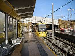 Derker tram stop, on its opening day | |
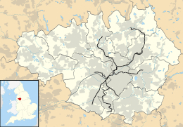 Derker Location of Derker in Greater Manchester | |
| Location | |
| Place | Derker |
| Local authority | Oldham |
| Coordinates | 53°32′59″N 2°06′06″W / 53.5498°N 2.1016°WCoordinates: 53°32′59″N 2°06′06″W / 53.5498°N 2.1016°W |
| Grid reference | SD933058 |
| Platforms | 2 |
| Fare zone information | |
| Metrolink Zone | L |
| Present status | In operation |
| Operations | |
| Original operator | British Rail |
| History | |
| Opened | 1985 |
| Closed as rail station | 3 October 2009 |
| Conversion to Metrolink operation | 16 December 2012[1] |
|
| |
Derker is a stop on the Oldham and Rochdale Line (ORL) of Greater Manchester's light-rail Metrolink system. It opened to passengers on 16 December 2012 and is located in the Derker area of Oldham, England.
History
Derker railway station was opened, initially on an experimental basis, on 30 August 1985[2] by British Rail to replace Royton Junction station, ½ mile further along the line.
The station closed on 3 October 2009, was converted to light rail, and re-opened as Derker Metrolink station on 16 December 2012. The station is served by a 254 space Park and Ride car park, which is immediately adjacent to the station and is accessed from Cromford Street.[1]
Service pattern
- 12 minute service to Shaw and Crompton with double trams in the peak
- 12 minute service to Rochdale Town Centre with double trams in the peak
- 6 minute service to East Didsbury with double trams in the peak
| Preceding station | Following station | |||
|---|---|---|---|---|
towards East Didsbury | East Didsbury – Rochdale Town Centre Line | towards Rochdale Town Centre |
||
| Historical railways | ||||
| Oldham Mumps | Regional Railways Oldham Loop Line |
Royton Junction | ||
Connecting bus routes
| Route | Destination 1 | Destination 2 | Operator | Service | Stop Location |
|---|---|---|---|---|---|
| 410[3] | Circular via Higginshaw, Oldham |
N/A | MCT | Mon-Sat Daytime | Yates Street |
| 411[4] | Circular via Derker, Littlemoor, Waterhead, Greenacres, Clarksfield, Roxbury, Glodwick, Oldham |
N/A | MCT | Mon-Sat Daytime | Yates Street |
| 58[5] | Rochdale via Shaw and Crompton |
Middleton via Oldham |
First | Mon-Sat Daytime | Shaw Road |
| 59[6] | Rushcroft via Shaw and Crompton |
Manchester |
First | Daytime & Evening | Shaw Road |
References
- 1 2 Kirby, Dean (12 December 2012). "Shaw and Crompton Metrolink trams start this Sunday". Manchester Evening News. Archived from the original on 15 December 2012. Retrieved 12 December 2012.
- ↑ Alan Bevan, ed. (1998). A—Z of Rail Reopenings. Railway Development Society. Warwick: Warwick Printing Company. ISBN 0-901283-13-4.
- ↑ "Archived copy" (PDF). Archived (PDF) from the original on 4 March 2016. Retrieved 31 May 2015.
- ↑ "Archived copy" (PDF). Archived (PDF) from the original on 4 March 2016. Retrieved 31 May 2015.
- ↑ "Archived copy" (PDF). Archived (PDF) from the original on 2 April 2015. Retrieved 31 May 2015.
- ↑ "Archived copy" (PDF). Archived (PDF) from the original on 4 March 2016. Retrieved 31 May 2015.
- ↑ "Transport for Greater Manchester - Journey Planning - Network Maps". Transport for Greater Manchester. Archived from the original on 2 November 2012. Retrieved 13 February 2013.
External links
| Wikimedia Commons has media related to Derker Metrolink station. |
| Oldham Lines | ||||||||||||||||||||||||||||||||||||||||||||||||||||||||||||||||||||||||||||||||||||||||||||||||||||||||||||||||||||||||||||||||||||||||||||||||||||||||||||||||||||||||||||||||||||||||||||||||||||||||||||||||||||
|---|---|---|---|---|---|---|---|---|---|---|---|---|---|---|---|---|---|---|---|---|---|---|---|---|---|---|---|---|---|---|---|---|---|---|---|---|---|---|---|---|---|---|---|---|---|---|---|---|---|---|---|---|---|---|---|---|---|---|---|---|---|---|---|---|---|---|---|---|---|---|---|---|---|---|---|---|---|---|---|---|---|---|---|---|---|---|---|---|---|---|---|---|---|---|---|---|---|---|---|---|---|---|---|---|---|---|---|---|---|---|---|---|---|---|---|---|---|---|---|---|---|---|---|---|---|---|---|---|---|---|---|---|---|---|---|---|---|---|---|---|---|---|---|---|---|---|---|---|---|---|---|---|---|---|---|---|---|---|---|---|---|---|---|---|---|---|---|---|---|---|---|---|---|---|---|---|---|---|---|---|---|---|---|---|---|---|---|---|---|---|---|---|---|---|---|---|---|---|---|---|---|---|---|---|---|---|---|---|---|---|---|---|
| ||||||||||||||||||||||||||||||||||||||||||||||||||||||||||||||||||||||||||||||||||||||||||||||||||||||||||||||||||||||||||||||||||||||||||||||||||||||||||||||||||||||||||||||||||||||||||||||||||||||||||||||||||||
| Tram stops |
|   | ||||||||||||||||||
|---|---|---|---|---|---|---|---|---|---|---|---|---|---|---|---|---|---|---|---|---|
| Operations |
| |||||||||||||||||||
| History (Timeline) |
| |||||||||||||||||||
| Proposed developments |
| |||||||||||||||||||
This article is issued from
Wikipedia.
The text is licensed under Creative Commons - Attribution - Sharealike.
Additional terms may apply for the media files.