Clarendon, South Australia
| Clarendon South Australia | |||||||||||||||
|---|---|---|---|---|---|---|---|---|---|---|---|---|---|---|---|
 Clarendon Weir | |||||||||||||||
 Clarendon | |||||||||||||||
| Coordinates | 35°07′0″S 138°38′0″E / 35.11667°S 138.63333°ECoordinates: 35°07′0″S 138°38′0″E / 35.11667°S 138.63333°E | ||||||||||||||
| Population | 638 (2006 census)[1] | ||||||||||||||
| Established | 1840 | ||||||||||||||
| Postcode(s) | 5157 | ||||||||||||||
| Elevation | 188 m (617 ft) | ||||||||||||||
| Location | 35.5 km (22 mi) from Adelaide | ||||||||||||||
| LGA(s) | City of Onkaparinga | ||||||||||||||
| Region | Southern Adelaide[2] | ||||||||||||||
| County | Adelaide[3] | ||||||||||||||
| State electorate(s) | Heysen | ||||||||||||||
| Federal Division(s) | Mayo | ||||||||||||||
| |||||||||||||||
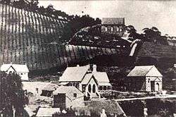
Vineyards and Police Station, date unknown

Clarendon bridge around 1869
Clarendon /ˈklærəndən/ is a small town in the Adelaide Hills, about 25–30 km south of the Adelaide city centre.
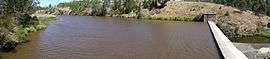
The Clarendon Weir is located in the town area on the Onkaparinga River.
History
On 21 October 1840, Richard Blundell was granted the title to Section 801 Hundred of Noarlunga. This was subsequently subdivided and by 1866 the town was described as a regional centre ‘in the midst of a fine agricultural district, where wheat, peas, and potatoes are largely grown’.
Early trade was built around local vineyards and around proximity to the Onkaparinga River. From 1894 to 1896 the Clarendon Weir was constructed, enhancing the local economy.
In the last 20 years a restoration programme has seen the town's heritage buildings restored.
Notes
- ^ Old Reynella - European History and Heritage
- ↑ Australian Bureau of Statistics (25 October 2007). "Clarendon (State Suburb)". 2006 Census QuickStats. Retrieved 2011-03-28.
- ↑ "Southern Adelaide SA Government region" (PDF). The Government of South Australia. Retrieved 17 April 2017.
- ↑ "Search result for "County of Adelaide, CNTY" with the following data sets selected - "Counties" and "Local Government Areas"". Property Location SA Map Viewer. Government of South Australia. Retrieved 24 April 2017.
External links
- ClarendonSA.com.au – Book detailing the historic buildings in the local area, written and illustrated by a local artist
This article is issued from
Wikipedia.
The text is licensed under Creative Commons - Attribution - Sharealike.
Additional terms may apply for the media files.