Kangarilla, South Australia
| Kangarilla South Australia | |||||||||||||||
|---|---|---|---|---|---|---|---|---|---|---|---|---|---|---|---|
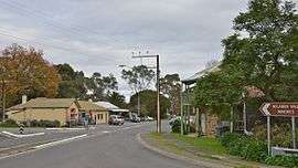 Main street of Kangarilla | |||||||||||||||
 Kangarilla | |||||||||||||||
| Coordinates | 35°08′53″S 138°39′36″E / 35.148°S 138.660°ECoordinates: 35°08′53″S 138°39′36″E / 35.148°S 138.660°E | ||||||||||||||
| Population | 928 (2006 census)[1] | ||||||||||||||
| Postcode(s) | 5157 | ||||||||||||||
| Elevation | 195 m (640 ft) | ||||||||||||||
| Location | 41 km (25 mi) from Adelaide | ||||||||||||||
| LGA(s) | City of Onkaparinga | ||||||||||||||
| Region | Southern Adelaide[2] | ||||||||||||||
| County | Adelaide[3] | ||||||||||||||
| Federal Division(s) | Division of Mayo | ||||||||||||||
| |||||||||||||||
Kangarilla is a town near Adelaide, South Australia. It lies within the City of Onkaparinga and has postcode 5157. At the 2006 census, Kangarilla had a population of 928.[1]
History
The land around Kangarilla was first settled in around 1840, with wheat and vineyards the main produce. A town was founded in 1849 by John Bottrill, and properly surveyed in 1860.[4] The name was changed regularly in the early days; originally called Scaldwell, then Eyre Flat, the name "Kangarilla" (a word from the local Kaurna language meaning "place of two springs") was settled upon in 1862.[4]
The historic settlement of Dashwood Gully (also known as Dashwoods Gully) existed within the present-day bounded locality of Kangarilla. It was named for George Frederick Dashwood, who settled there in 1841[5] and was appointed as a member of the South Australian parliament in 1843. The first Dashwood's Gully post office opened in November 1863 and closed in 1867; a second post office opened from December 1871 to December 1930.[6][7][8]
See also
Notes and references
- 1 2 Australian Bureau of Statistics (25 October 2007). "Kangarilla (State Suburb)". 2006 Census QuickStats. Retrieved 9 August 2011.
- ↑ "Southern Adelaide SA Government region" (PDF). The Government of South Australia. Retrieved 17 April 2017.
- ↑ "Search result for "County of Adelaide, CNTY" with the following data sets selected - "Counties" and "Local Government Areas"". Property Location SA Map Viewer. Government of South Australia. Retrieved 24 April 2017.
- 1 2 http://www.southaustralianhistory.com.au/kangarilla.htm
- ↑ "Placename Details: Dashwood Gully". Property Location Browser. 25 July 2007. SA0017978. Retrieved 22 December 2017.
Feature Type: Gully; Derivation of Name: Captain G F Dashwood, RN; Other Details: Captain Dashwood settled there in 1841.
- ↑ "'A hill's post office near Dashwood's Gully' [PRG 1316/12/150] • Photograph". State Library of South Australia. Retrieved 22 December 2017.
- ↑ "Dashwood's Gully (1)". Post Office Reference. Premier Postal. Retrieved 22 December 2017.
- ↑ "Dashwood's Gully (2)". Post Office Reference. Premier Postal. Retrieved 22 December 2017.