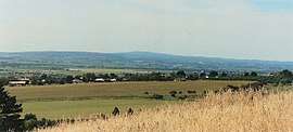
McLaren Vale, South Australia
| McLaren Vale Adelaide, South Australia | |||||||||||||||
|---|---|---|---|---|---|---|---|---|---|---|---|---|---|---|---|
 | |||||||||||||||
 McLaren Vale | |||||||||||||||
| Coordinates | 35°13′11″S 138°32′28″E / 35.219773°S 138.541119°ECoordinates: 35°13′11″S 138°32′28″E / 35.219773°S 138.541119°E[1] | ||||||||||||||
| Population | 3,842 (2016 census)[2] | ||||||||||||||
| • Density | 985/km2 (2,550/sq mi) | ||||||||||||||
| Established | 1838 | ||||||||||||||
| Postcode(s) | 5171 | ||||||||||||||
| Area | 3.9 km2 (1.5 sq mi) | ||||||||||||||
| Time zone | ACST (UTC+9:30) | ||||||||||||||
| • Summer (DST) | ACST (UTC+10:30) | ||||||||||||||
| Location | 41 km (25 mi) from Adelaide | ||||||||||||||
| LGA(s) | City of Onkaparinga[1] | ||||||||||||||
| Region | Southern Adelaide[3] | ||||||||||||||
| County | Adelaide[4] | ||||||||||||||
| State electorate(s) | Mawson [5] | ||||||||||||||
| Federal Division(s) | Mayo[6] | ||||||||||||||
| |||||||||||||||
McLaren Vale (postcode 5171) is a small rural town in South Australia famous for producing world class red wine. At the 2011 census, McLaren Vale had a population of 3,861.[7][8]
The township was formed in 1923 from a merging of the two original villages of Gloucester and Bellevue, which were established in the 1840s by British and Irish pioneers.
The McLaren Vale wine region surrounds the town.
Children's author Alexander S. Foxhall was born in McLaren Vale, as was former Newsboys frontman Peter Furler.
The Coast to Vines rail trail passes through Mclaren Vale. There was a station at Mclaren Vale on the former Willunga railway line that it follows.
The main road junction into the town, at Victor Harbor Road and Main Road, has over the years been notorious for fatal crashes. In 2011, construction stated on an overpass, to remove the threat of right hand turns through high speed traffic. The overpass opened in late 2012.
There were once two supermarkets in the town, a Foodland and a BI-LO (where Browse and Save currently operates), until Foodland was sold, and Bilo moved into the vacancy. In 2006, BI-LO converted to Coles along with the national conversion. In 2011, it was announced that the shopping centre would be undergoing an upgrade, with a Target Country.[9] Target Country will occupy the current Coles location, after a new, bigger Coles is built behind its current location. The complete shopping centre is expected to open in early 2013.
McLaren Vale is located within the federal division of Mayo, the state electoral district of Mawson and the local government area of the City of Onkaparinga.[6][5][1]
References
- 1 2 3 "Search results for 'McLaren Vale, LOCB' with the following datasets being selected – 'Suburbs and Localities', 'Counties', "government Towns', 'Local Government Areas','Postcodes', 'SA Government Regions', 'Gazetteer' and 'Roads'". Location SA Map Viewer. Government of South Australia. Retrieved 16 June 2018.
- ↑ Australian Bureau of Statistics (27 June 2017). "McLaren Vale (State Suburb)". 2016 Census QuickStats. Retrieved 5 February 2018.

- ↑ "Southern Adelaide SA Government region" (PDF). The Government of South Australia. Retrieved 17 April 2017.
- ↑ "Search result for "County of Adelaide, CNTY" with the following data sets selected - "Counties" and "Local Government Areas"". Property Location SA Map Viewer. Government of South Australia. Retrieved 24 April 2017.
- 1 2 Mawson (Map). Electoral District Boundaries Commission. 2016. Retrieved 2 March 2018.
- 1 2 "Federal electoral division of Mayo". Australian Electoral Commission. Retrieved 16 June 2018.
- ↑ Australian Bureau of Statistics (31 October 2012). "McLaren Vale (State Suburb)". 2011 Census QuickStats. Retrieved 26 September 2012.
- ↑ "City of Onkaparinga suburb boundaries map". City of Onkaparinga. 9 January 2014. Retrieved 8 October 2014.
- ↑ Lucid Consulting, McLaren Vale Redevelopment Archived 13 October 2009 at the Wayback Machine.
External links
291555293 McLaren Vale, South Australia on OpenStreetMap