Darah Sof District
| Darah Sof دره صوف | |
|---|---|
| District | |
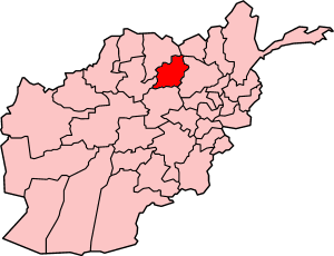 | |
 Darah Sof Location in Afghanistan | |
| Coordinates: 35°45′03″N 67°39′58″E / 35.7508°N 67.6662°ECoordinates: 35°45′03″N 67°39′58″E / 35.7508°N 67.6662°E | |
| Country |
|
| Province | Samangan Province |
| Population | |
| • Total | 107,000 |
| Time zone | UTC+04:30 (AST) |
Darah Sof (Dari: دره صوف) is a district of Samangan Province in Afghanistan. It is located about 130 kilometres (81 mi) from the city of Samangan and 200 kilometres (120 mi) from the city of Mazar-i-Sharif, in Balkh Province.
A large part of Darah Sof is surrounded by hills, where a type of wheat called Lalm (للم) is grown. A river in Darah Sof called Qalah Sarkori makes the area very lush and fertile. Many of the residents have installed small turbines to extract power from this river. The district of Darah Sof was recently divided into two districts; Darah Sof Balla (the upper valley) and Darah Sof Payan (the lower valley).
There are approximately 107,000 residents in Darah Sof,[1] with the majority of Hazara ethnicity. The district has one high school, eleven elementary schools, and two religious schools.
On 15 March 1979, an uprising against the Democratic People's Party of Afghanistan occurred. A work project is currently planned to improve the road between Darah Sof and Mazar Sharif city. This project is funded by the Correa government, with working capital of $60 million.
Etymology
The name Darah Sof may be rendered in many, many, different ways in western languages. Some examples are: Dar-I-Suf, Dare Suf, Darya Ye Suf; the preceding with Sof instead of Suf.
See also
References
- ↑ "Samangan" (pdf). Government of Afghanistan. Retrieved 2010-10-19.
External links
- General information about the Sof Valley by Persian http://www.kabul.net.au/Topics/56.php
- Dara Sof public information website http://www.daresufman.blogfa.com/