Cumbal Volcano
| Cumbal | |
|---|---|
| Volcán Cumbal | |
 Cumbal in 2011 | |
| Highest point | |
| Elevation | 4,764 m (15,630 ft) |
| Prominence | 1,575 m (5,167 ft) |
| Listing | Ultra |
| Coordinates | 0°56′56″N 77°53′17″W / 0.949°N 77.888°WCoordinates: 0°56′56″N 77°53′17″W / 0.949°N 77.888°W |
| Geography | |
 Cumbal Location of Cumbal in Colombia | |
| Location | Colombia |
| Parent range |
Central Ranges Andes |
| Geology | |
| Mountain type | Andesitic stratovolcano |
| Last eruption | December 1926 |
Cumbal is a stratovolcano located in Nariño, Colombia. It is the southernmost historically active volcano of Colombia. The volcano is dominated by andesites.[1]
The volcano was the crash site of TAME Flight 120, which struck one of its sides while in a go-around approach to Tulcán on January 28, 2002. There were no survivors among the 94 occupants.
Gallery
 1989
1989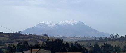 2007
2007
See also
References
| Wikimedia Commons has media related to Cumbal Volcano. |
- ↑ Plancha 447-447bis, 2003
Bibliography
- Parra, Eduardo, and Marta Velásquez. 2003. Plancha 447 Ipiales & 447bis Tallambí - 1:100,000, 1. INGEOMINAS. Accessed 2017-06-06.
External links
Treasures of Colombia | |||||||||||||||||||||||||||||||||||||||||||||||||||||||||||||||
|---|---|---|---|---|---|---|---|---|---|---|---|---|---|---|---|---|---|---|---|---|---|---|---|---|---|---|---|---|---|---|---|---|---|---|---|---|---|---|---|---|---|---|---|---|---|---|---|---|---|---|---|---|---|---|---|---|---|---|---|---|---|---|---|
| |||||||||||||||||||||||||||||||||||||||||||||||||||||||||||||||
| |||||||||||||||||||||||||||||||||||||||||||||||||||||||||||||||
| |||||||||||||||||||||||||||||||||||||||||||||||||||||||||||||||
| |||||||||||||||||||||||||||||||||||||||||||||||||||||||||||||||
| |||||||||||||||||||||||||||||||||||||||||||||||||||||||||||||||
Source: Wills, Fernando et al. 2001. Nuestro patrimonio - 100 tesoros de Colombia - Our heritage - 100 treasures of Colombia, 1-311. El Tiempo. | |||||||||||||||||||||||||||||||||||||||||||||||||||||||||||||||
| Western Ranges | | |
|---|---|---|
| Central Ranges |
| |
| Eastern Ranges |
| |
| Other | ||
| Source |
| |
This article is issued from
Wikipedia.
The text is licensed under Creative Commons - Attribution - Sharealike.
Additional terms may apply for the media files.