Amazonas Department
| Amazonas Department Departamento del Amazonas | |||
|---|---|---|---|
| Department | |||
| |||
|
Motto(s): Entre todos podemos (Spanish: All of us, can) | |||
| Anthem: Himno de Amazonas | |||
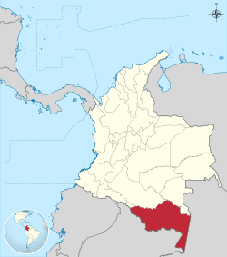 Amazonas shown in red | |||
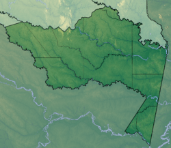 Topography of the department | |||
| Country |
| ||
| Region | Amazonía Region | ||
| Established | October 5, 1991 | ||
| Capital | Leticia | ||
| Government | |||
| • Governor | Manuel Antonio Carebilla Cuellar(2016-2019) | ||
| Area[1] | |||
| • Total | 109,665 km2 (42,342 sq mi) | ||
| Area rank | 1st | ||
| Population (2013)[2] | |||
| • Total | 74,541 | ||
| • Rank | 30th | ||
| • Density | 0.68/km2 (1.8/sq mi) | ||
| Time zone | UTC-05 | ||
| ISO 3166 code | CO-AMA | ||
| Website | www.amazonas.gov.co | ||
.svg.png)
.svg.png)
Department of Amazonas (Spanish: Departamento del Amazonas, Spanish pronunciation: [amaˈsonas]) is a department of Colombia in the south of the country. It is the largest department in area while also having the 3rd smallest population. Its capital is Leticia. Its name comes from the Amazon River which drains the department.
Toponymy
The department name comes from the name of the Amazon River. The river was named by the Spanish explorer Francisco de Orellana (1511 - 1546), who, on his voyage of exploration, said he was attacked by "fierce females" looked like Amazons of the Greek mythology, however, the existence of a female warrior tribe in that time hasn’t been demonstrated and it is possible that they were long-haired Native American warriors who impressed the conqueror who called the jungle and the river with the name of Amazon.
Culture
The following ethnic groups are found in the department: Bora, Cocama, Macuna, Mirana, Okaina, Ticunas, Tucano, Uitoto, Yagua and Yucuna, among others. These groups are more than 5,000 years old.
National parks
Department of Amazonas covers 109,665 km2 of area protected,most it under name of "forest reserve" since 1959, currently has 4 "National Parks" (Amacayacú, Cahuinarí, Yagoje Apaporis and Rio Puree).
Municipalities and communities
- El Encanto
- La Chorrera
- La Pedrera
- La Victoria
- Leticia
- Mirití-Paraná
- Puerto Alegría
- Puerto Arica
- Puerto Nariño
- Puerto Santander
- Tarapacá
.svg.png)
References
- ↑ "Nuestro Departamento: Información general: Geografía". Gobernación del Amazonas.
- ↑ "DANE". Archived from the original on November 13, 2009. Retrieved February 13, 2013.
External links

- Territorial-Environmental Information System of Colombian Amazon SIAT-AC website
- Essential Travel Information to Leticia and its Surroundings
 | ||