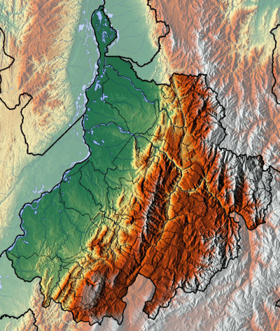
Chicamocha Canyon
| Chicamocha Canyon | |
|---|---|
| Cañón del Chicamocha | |
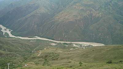
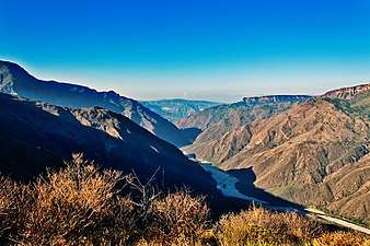
 View of the Chicamocha River in the Chicamocha Canyon | |
 Chicamocha Canyon | |
| Floor elevation | 900–1,900 m (3,000–6,200 ft) |
| Long-axis direction | NW-SE |
| Long-axis length | 227 km (141 mi) |
| Area | 108,000 ha (270,000 acres) |
| Depth | 2,000 m (6,600 ft) |
| Geology | |
| Type | River canyon |
| Age | Oligocene-recent |
| Geography | |
| Bounded by |
Mesa de Los Santos (north) Altiplano Cundiboyacense (south) |
| Coordinates | 6°45′N 73°02′W / 6.750°N 73.033°WCoordinates: 6°45′N 73°02′W / 6.750°N 73.033°W |
| Population centers | Soatá, Capitanejo, Cepitá, Pescadero, Jordán, Betulia, Girón |
| Traversed by | National Route 45A |
| Watercourses | Chicamocha River |
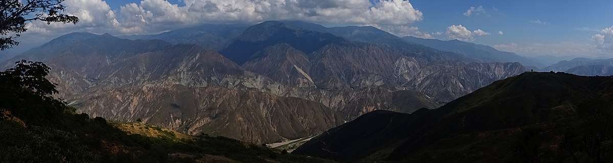
The Chicamocha Canyon (/ˌtʃiːkəˈmoʊtʃə/ CHEE-kə-MOH-chə, Spanish: Cañón del Chicamocha) is a steep sided canyon carved by the Chicamocha River in Colombia. With a maximum depth of 2,000 metres (6,600 ft), an area of 108,000 hectares (270,000 acres) and a length of 227 kilometres (141 mi), the canyon is the second-deepest worldwide. The canyon is situated in the departments of Boyacá and Santander, stretching from Soatá in the southeast to Girón and Betulia in the northwest. The canyon is a mayor tourist attraction at approximately 55 kilometres (34 mi) from the capital of Santander, Bucaramanga and close to backpacker destination San Gil.
The canyon is one of the treasures of Colombia. In 2009, the canyon was nominated as one of the 7 natural wonders contest.[1] Since 2013, a yearly set of running contests, the Chicamocha Canyon Race, are held around the canyon.[2]
Etymology
The name Chicamocha in the Chibcha language of the Muisca means "silver-plated son, under the moon on the mountain range".[3]
Description
Chicamocha Canyon has a length of 227 kilometres (141 mi),[4] extends over 108,000 hectares (270,000 acres),[5] and a maximum depth of 2,000 metres (6,600 ft), making it the second-deepest canyon in the world.[6] The canyon was formed in a period since about 30 million years ago. The southern extension near Soatá, contained a Pleistocene paleolake, Lake Soatá. In the Soatá Formation, fossils of this period have been found. The canyon is currently administered by Chicamocha National Park.
The canyon is the result of the erosion caused by the Chicamocha River, which erosional forces created deep cliffs on both sides. The Chicamocha Canyon begins near the town of Soatá in the Department of Boyacá and flows mainly through Santander, extending all the way to the municipality of Lebrija. This geographic feature was caused by the movement of tectonic plates that extend from the Chicamocha Canyon to other regions such as Bucaramanga. South of Zapatoca, the Chicamocha River and the Suárez River form the Sogamoso River.[7] The canyon represents the southern boundary of the Mesa de Los Santos, a seismically active area known as the Bucaramanga Nest.[8]
The climate in the highest parts of the canyon near Soatá is cold and humid, changing into a dry and hotter climate near Capitanejo.[9] The lowest areas in the northwest at around 900 metres (3,000 ft) elevation have the driest and hottest climate.[10] The vegetation of the canyon north of San Gil is of a dry tropical forest.[11]
History
The region of the Chicamocha Canyon before the Spanish conquest was inhabited by the Guane.[12]
Geology
.jpg)
Chicamocha Canyon traverses formations of Precambrian to Pleistocene age. In the southeasternmost part, the Soatá Formation forms the youngest geological unit, deposited in terraces surrounding Lake Soatá. Lake Soatá was probably close to 400 metres (1,300 ft) deep.[13] The paleolake was approximately 30 kilometres (19 mi) long and widest between Soatá and Boavita at 7 kilometres (4.3 mi).[14] Fossils of Haplomastodon waringi, Neochoerus sp. and Odocoileus cf. salinae have been found here.[15] The fossil content is fragmentary.[16]
The canyon flanks contain outcrops of the early Paleozoic Silgará Formation, the Devonian Floresta Formation, the Jurassic Pescadero Quartzmonzonite, Jordán,[17] and San Gil Formations,[18] and the Cretaceous Tibú-Mercedes, Aguardiente, Capacho,[19] La Luna, Paja, Rosablanca,[20] and El Tambor Formations.[21][22]
Near Jordán, the Las Cruces-Curití, Los Santos and Aratoca Faults cross-cut and form the canyon,[21] around Curití, the canyon is cut by the Bucaramanga-Santa Marta Fault and near Covarachía the Chicamocha Fault forms the trace of the canyon.[22]
Near Barichara on the flanks of the canyon, gypsum is mined.[23]
Gallery

 Fauna
Fauna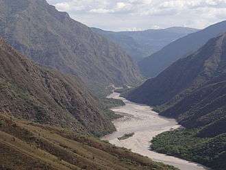
Panorama
See also
| Wikimedia Commons has media related to Chicamocha Canyon. |
References
- ↑ Selection of Chicamocha Canyon - El Tiempo
- ↑ Chicamocha Canyon Race
- ↑ (in Spanish) Meaning of Chicamocha
- ↑ (in Spanish) Cañones de Colombia, una cadena infinita de montañas
- ↑ (in Spanish) Nuestro Cañón sería 'bien de interés patrimonial universal'
- ↑ (in Spanish) ¿Por qué el Cañón del Chicamocha fue nominado a las 7 maravillas naturales del mundo?
- ↑ Ortíz, 1958, p.5
- ↑ Ortíz, 1958, p.7
- ↑ Reyes et al., 2007, p.23
- ↑ Reyes et al., 2007, p.25
- ↑ Pulido González, 1985, p.6
- ↑ (in Spanish) Guane people and their territories
- ↑ Villarroel et al., 2001, p.88
- ↑ Villarroel et al., 2001, p.81
- ↑ Soatá at Fossilworks.org
- ↑ Villarroel et al., 1996, p.85
- ↑ Pulido González, 1985, p.8
- ↑ Pulido González, 1985, p.9
- ↑ Reyes et al., 2007, p.36
- ↑ Pulido González, 1985, p.11
- 1 2 Plancha 135, 2009
- 1 2 Plancha 136, 2009
- ↑ Pulido González, 1985, p.16
Bibliography
- Cabrera Ortiz, Wenceslao. 1958. La Mesa de Los Santos. Boletín de la Sociedad Geográfica de Colombia 58. 1–32. Accessed 2018-06-21.
- Pulido González, Orlando. 1985. Reseña explicativa del Mapa geológico preliminar de la Plancha 135 San Gil - 1:100,000, 1–24. INGEOMINAS. Accessed 2018-06-21.
- Reyes, Italo et al. 2007. Investigación geológica e hidrogeológica preliminar en los sectores norte y centro del Departamento de Boyacá. Informe final, 1–189. INGEOMINAS. Accessed 2018-06-21.
- Villarroel, Carlos; Ana Elena Concha, and Carlos Macía. 2001. El Lago Pleistoceno de Soatá (Boyacá, Colombia): Consideraciones estratigráficas, paleontológicas y paleoecológicas. Geología Colombiana 26. 79–93.
- Villarroel, Carlos; Jorge Brieva B., and Alberto Cadena. 1996. La Fauna de Mamíferos Fósiles del Pleistoceno de Jútua, Municipio de Soatá (Boyacá, Colombia). Geología Colombiana 21. 81–87.
Maps
- Royero Gutiérrez, José María, and Rodrigo Vargas Higuera. 1999. Mapa Geológico de Santander 1:300,000, 1. INGEOMINAS. Accessed 2017-09-21.
- Angarita, Leonidas; Víctor Carrillo; Alfonso Castro; Rommel Daconte; Mario Niño; Orlando G. Pulido; J. Antonio Rodríguez; José María Royero, and Rosalba Salinas, Carlos Ulloa and Rodrigo Vargas. 2009. Plancha 135 - San Gil - 1:100,000, 1. INGEOMINAS. Accessed 2017-06-06.
- Vargas, Rodrigo; Alfonso Arias; Luis Jaramillo, and Noel Tellez. 1984. Plancha 136 - Málaga - 1:100,000, 1. INGEOMINAS. Accessed 2017-06-06.
Treasures of Colombia | |||||||||||||||||||||||||||||||||||||||||||||||||||||||||||||||
|---|---|---|---|---|---|---|---|---|---|---|---|---|---|---|---|---|---|---|---|---|---|---|---|---|---|---|---|---|---|---|---|---|---|---|---|---|---|---|---|---|---|---|---|---|---|---|---|---|---|---|---|---|---|---|---|---|---|---|---|---|---|---|---|
| |||||||||||||||||||||||||||||||||||||||||||||||||||||||||||||||
| |||||||||||||||||||||||||||||||||||||||||||||||||||||||||||||||
| |||||||||||||||||||||||||||||||||||||||||||||||||||||||||||||||
| |||||||||||||||||||||||||||||||||||||||||||||||||||||||||||||||
| |||||||||||||||||||||||||||||||||||||||||||||||||||||||||||||||
Source: Wills, Fernando et al. 2001. Nuestro patrimonio - 100 tesoros de Colombia - Our heritage - 100 treasures of Colombia, 1-311. El Tiempo. | |||||||||||||||||||||||||||||||||||||||||||||||||||||||||||||||