Chiles (volcano)
| Chiles | |
|---|---|
| Volcán Chiles | |
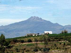 Chiles in 2010 | |
| Highest point | |
| Elevation | 4,723 m (15,495 ft) [1] |
| Listing |
Volcanoes of Colombia Volcanoes of Ecuador |
| Coordinates | 0°49′16″N 77°56′6″W / 0.82111°N 77.93500°WCoordinates: 0°49′16″N 77°56′6″W / 0.82111°N 77.93500°W [1] |
| Geography | |
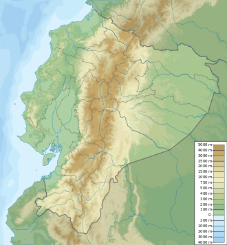 Chiles Location of Chiles in Colombia & Ecuador | |
| Location |
Nariño, Colombia Carchi, Ecuador |
| Parent range |
Central Ranges Cordillera Real Andes |
| Geology | |
| Age of rock | Pleistocene |
| Mountain type | Andesitic stratovolcano |
| Volcanic belt | Northern Volcanic Zone, Andean Volcanic Belt |
| Last eruption | July 17, 1936(?)[1] |
| Climbing | |
| Easiest route | Ecuador side - Class 3 scramble |
Chiles is a volcano on the border of Colombia and Ecuador. It lies 3 kilometres (2 mi) south-east of the volcano Cerro Negro de Mayasquer, and the two peaks are considered part of the same Chiles-Cerro Negro volcanic complex. The volcanoes, together with the Cumbal are andesitic in rock type.[2] A 1936 eruption reported by the Colombian government agency Ingeominas may have been from the Ecuadorean volcano Reventador, otherwise the volcano has not erupted for around 160,000 years.[1]
Recent activity
On 20 October 2014, the Servicio Geológico Colombiano (SGC) reported that a M 5.8 earthquake, the largest to date, occurred in the vicinity of the Cerro Negro de Mayasquer and Chiles volcanoes at a depth of less than 10 km. The event was felt to the north in Pasto, Colombia, and to the south in Quito, Ecuador.
On 21 October 2014 SGC raised the alert level for the volcanic complex to orange (level 3 of 4) noting that a seismic swarm characterized by 4,300 earthquakes was detected in an 18-hour period. Hypocenters were located 1–4 km southwest of Chiles volcano at depths of 3–5 km and local magnitudes between M 0.2 and 4.5. Inhabitants felt 11 of the events. On 22 October a report noted that the total number of earthquakes recorded on 21 October 2014 reached 7,717, which was the largest number of earthquakes recorded on one day since the installation of a local seismic network in November 2013. Several swarms have occurred in the area since February 2013. By the end of November 2014 over 132,000 earthquakes occurred within a narrow area .5 – 6 km SW of the summit of Chiles.
Gallery
 2013
2013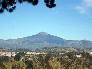 2015
2015
See also
References
| Wikimedia Commons has media related to Volcán Chiles. |
- 1 2 3 4 "Chiles-Cerro Negro". Global Volcanism Program. Smithsonian Institution. Retrieved May 2, 2011.
- ↑ Plancha 447-447bis, 2003
Bibliography
- Parra, Eduardo, and Marta Velásquez. 2003. Plancha 447 Ipiales & 447bis Tallambí - 1:100,000, 1. INGEOMINAS. Accessed 2017-06-06.
Further reading
- Monsalve B., María Luisa, and Carlos Andrés Laverde C. 2016. Contribución al registro de actividad de los volcanes Chiles y Cerro Negro (frontera colombo-ecuatoriana). Boletín de Geología, Universidad Industrial de Santander 38. 61-78. Accessed 2017-06-15.
External links
| Western Ranges |  | |
|---|---|---|
| Central Ranges |
| |
| Eastern Ranges |
| |
| Other | ||
| Source |
| |