Cerro Machín
| Cerro Machín | |
|---|---|
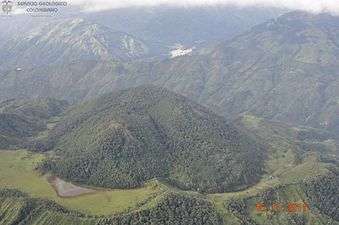
 Cerro Machín in 2016 | |
| Highest point | |
| Elevation | 2,650+ metres (8,694 feet) [1] |
| Listing | Volcanoes of Colombia |
| Coordinates | 04°29′00″N 75°23′30″W / 4.48333°N 75.39167°WCoordinates: 04°29′00″N 75°23′30″W / 4.48333°N 75.39167°W [1] |
| Geography | |
 Cerro Machín Location of Cerro Machín in Colombia | |
| Location |
Tolima |
| Parent range |
Central Ranges Andes |
| Geology | |
| Age of rock | Pleistocene |
| Mountain type | Stratovolcano |
| Last eruption | 1180 ± 150 years[1] |
Cerro Machín is a stratovolcano located in Tolima Department, Colombia. Cerro Machin is a volcanic plug that is approximately the same age (1,000,000+ years) as the Ruiz-Tolima Massif and has the appearance of being part of that volcanic system. Its sisters are Nevado del Tolima, 17,060 feet (5,200 m); Santa Isabel, 16,240 feet (4,950 m), Nevado del Ruiz, 17,457 feet (5,321 m), plus nine other lesser volcanoes and a 10,000 feet (3,000 m) volcanic South Wall containing in excess of thirty volcanic domes.
Gallery
 2011
2011
See also
References
| Wikimedia Commons has media related to Cerro Machín. |
- 1 2 3 "Machín". Global Volcanism Program. Smithsonian Institution. Retrieved 2007-01-19.
| Western Ranges | | |
|---|---|---|
| Central Ranges |
| |
| Eastern Ranges |
| |
| Other | ||
| Source |
| |
This article is issued from
Wikipedia.
The text is licensed under Creative Commons - Attribution - Sharealike.
Additional terms may apply for the media files.