Putumayo Department
| Department of Putumayo Departamento del Putumayo | ||
|---|---|---|
| Department | ||
| ||
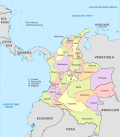
 Putumayo shown in red | ||
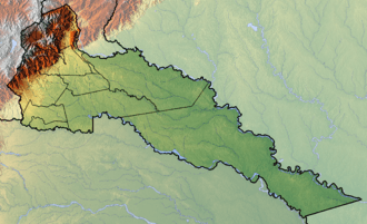 Topography of the department | ||
| Coordinates: 1°09′N 76°37′W / 1.150°N 76.617°WCoordinates: 1°09′N 76°37′W / 1.150°N 76.617°W | ||
| Country |
| |
| Region | Amazonía Region | |
| Established | 1991 | |
| (political) | Mocoa | |
| Government | ||
| • Governor | Sorrel Parisa Aroca Rodriguez(2016-2019) | |
| Area[1][2] | ||
| • Total | 24,885 km2 (9,608 sq mi) | |
| Area rank | 16th | |
| Population (2013)[3] | ||
| • Total | 337,054 | |
| • Rank | 26th | |
| • Density | 14/km2 (35/sq mi) | |
| Time zone | UTC-05 | |
| ISO 3166 code | CO-PUT | |
| Municipalities | 13 | |
| Website | www.putumayo.gov.co | |

Putumayo (Spanish pronunciation: [putuˈmaʝo]) is a department of Colombia. It is in the south-west of the country, bordering Ecuador and Peru. Its capital is Mocoa.
The word putumayo comes from the Quechua languages. The verb p'utuy means "to spring forth" or "to burst out", and mayu means river. Thus it means "gushing river".
History
Originally, the south west of the department was the territory of the Cofán Indians, the north west that of the Kamentxá Indians, and the center and south belonged to tribes that spoke Tukano languages (such as the Siona), and the east to tribes that spoke Witoto languages. Part of the Kamentxá territory was conquered by the Inca Huayna Cápac in 1492, who, after crossing the Cofán territory, established a Quechua population on the valley of Sibundoy, known today as Ingas. After the Inca defeat in 1533, the region was invaded by the Spanish in 1542, and from 1547 was administered by Catholic missions.
The current territory of Putumayo was linked to Popayan during the Spanish Colonial Period and in the first Republican decades belonged to the "Azuay Department", that included territories in Ecuador and Perú. Later a long process of territorial redistributions began:
- 1831: Popayán Province.
- 1857: Estado Federal del Cauca.
- 1886: Cauca Department.
- 1905: Intendencia del Putumayo.
- 1909: Intendencia del Caquetá.
- 1912: Comisaría Especial del Putumayo.
- 1953: Department of Nariño.
- 1957: Comisaría Especial del Putumayo.
- 1968: Intendencia Especial del Putumayo.
- 1991: Putumayo Department.
Municipalities
| Municipalities | Map |
|---|---|
.svg.png) |
See also
References
- ↑ "Nuestro departamento: Información general". Gobernación del Putumayo.
- ↑ Kline, Harvey F. (2012). "Putumayo, Department of". Historical Dictionary of Colombia. Lanham, Maryland: Scarecrow Press. p. 415. ISBN 978-0-8108-7813-6.
- ↑ "DANE". Archived from the original on 13 November 2009. Retrieved 13 February 2013.
External links
- (in Spanish) Government of Putumayo official website
- Territorial-Environmental Information System of Colombian Amazon SIAT-AC website
 | ||