Scarba
| Gaelic name | Sgarba |
|---|---|
| Pronunciation |
[ˈs̪kaɾapə] ( |
| Norse name | Skarpoe |
| Meaning of name | Old Norse for "sharp, stony, hilly terrain" |
| Location | |
 Scarba Scarba shown within Argyll and Bute | |
| OS grid reference | NM690044 |
| Coordinates | 56°10′37″N 5°43′12″W / 56.177°N 5.72°W |
| Physical geography | |
| Island group | Islay |
| Area | 1,474 hectares (5.7 sq mi) |
| Area rank | 39 [1] |
| Highest elevation | Cruach Scarba 449 metres (1,473 ft) |
| Administration | |
| Sovereign state | United Kingdom |
| Country | Scotland |
| Council area | Argyll and Bute |
| Demographics | |
| Population | Not permanently inhabited since the 1960s |
| Largest settlement | Kilmory Lodge |
| References | [2][3][4] |
Scarba (Scottish Gaelic: Sgarba) is a small island, in Argyll and Bute, Scotland, just north of the much larger island of Jura. The island was owned by Richard Hill, 7th Baron Sandys and has not been permanently inhabited since the 1960s.[3] It is now covered in heather and used for grazing animals. Kilmory Lodge is used seasonally as a shooting lodge, the island having a flourishing herd of red deer.
The island's name is from the Norse and may mean "sharp, stony, hilly terrain"[3] or "cormorant island".[5]
Description
| Cruach Scarba | |
|---|---|
| (Scottish Gaelic: 'Cruach Sgarba') | |
| Highest point | |
| Elevation | 449 m (1,473 ft) |
| Prominence | 449 m (1,473 ft) |
| Listing | Marilyn |
| Naming | |
| Translation | Hill of Scarba (Gaelic) |
| Pronunciation |
|
| Geography | |
| Location | Inner Hebrides, Scotland |
| OS grid | NM690044 |
| Topo map | OS Landranger 55 |
Scarba is not served by any public ferries, but access from Craobh Haven or Crinan Harbour is possible by arrangement with local boatmen. The rough summit ridge can be accessed from the harbour at the north end, from where a vehicle track leads up past Kilmory Lodge to a height of about 200 metres. After that, there are no paths or well defined routes, and the terrain becomes rough and boggy. The island rises steeply to a peak (Cruach Scarba) of 449 metres (1,473 ft). Although there are no technical difficulties, the summits are often shrouded in mist, through which navigation skill may be required. A cylindrical triangulation point marks the highest of several summits, which are surrounded by several small lochs.
Corryvreckan
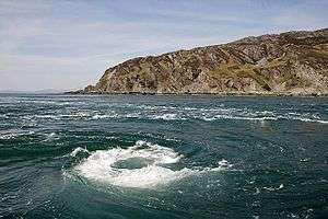
Between Scarba and Jura lies the Gulf of Corryvreckan, known for its whirlpool. Writing in 1549, Dean Monro wrote of "Skarbay" that between it and "Duray":
Ther runnes ane streame, above the power of all sailing and rowing, with infinite dangers, callit Corybrekan. This stream is aught myle lang, quhilk may not be hantit bot be certain tyds. This Skarbay is four myles lange from the west to the eist, and an myle breadth, ane high rough yle, inhabit and manurit, with some woods in it.[6]
Scarba and a few nearby islets (Lunga and the Garvellachs) are collectively the Scarba, Lunga and the Garvellachs National Scenic Area, one of 40 such areas in Scotlands, which are defined so as to identify areas of exceptional scenery and to ensure its protection by restricting certain forms of development.[7]
Gallery
 The Corryvreckan whirlpool
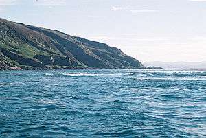
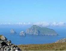
 The view from Luing looking towards Scarba
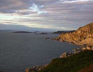 Na h-Urrachann, Isle of Scarba, looking north towards the Slate Islands
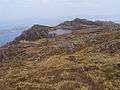 A view northwards along the summit ridge from a short distance north of the highest point.
Footnotes
- ↑ Area and population ranks: there are c. 300 islands over 20 ha in extent and 93 permanently inhabited islands were listed in the 2011 census.
- ↑ National Records of Scotland (15 August 2013) (pdf) Statistical Bulletin: 2011 Census: First Results on Population and Household Estimates for Scotland - Release 1C (Part Two). "Appendix 2: Population and households on Scotland’s inhabited islands". Retrieved 17 August 2013.
- 1 2 3 Haswell-Smith (2004) p. 60
- ↑ Ordnance Survey. OS Maps Online (Map). 1:25,000. Leisure.
- ↑ Mac an Tàilleir (2003) p. 104
- ↑ Monro (1594) "Skarbay" No. 16
- ↑ "National Scenic Areas". Scottish Natural Heritage. Retrieved 2018-05-24.
References
- Haswell-Smith, Hamish (2004). The Scottish Islands. Edinburgh: Canongate. ISBN 978-1-84195-454-7.
- Monro, Sir Donald (1549) Description of the Western Isles of Scotland. William Auld. Edinburgh - 1774 edition.
- Mac an Tàilleir, Iain (2003) Ainmean-àite/Placenames. (pdf) Pàrlamaid na h-Alba. Retrieved 26 August 2012.
External links
![]()
|  | ||||||||||||||||
|
| |||||||||||||||||
| |||||||||||||||||
| |||||||||||||||||
| |||||||||||||||||
| |||||||||||||||||
| |||||||||||||||||
| |||||||||||||||||