Lullingstone railway station
| Lullingstone | |
|---|---|
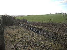 Platform remains in January 2012. | |
| Location | |
| Place | Lullingstone |
| Area | District of Sevenoaks |
| Grid reference | TQ530664 |
| Operations | |
| Original company | Southern Railway |
| Platforms | 4 planned (2 built) |
| History | |
| 2 April 1939 | Intended opening |
| Disused railway stations in the United Kingdom | |
|
Closed railway stations in Britain A B C D–F G H–J K–L M–O P–R S T–V W–Z | |
|
| |
Lullingstone railway station is an unopened station on the Maidstone East Line which was constructed to serve a proposed airport and expected residential development at Lullingstone near Eynsford in Kent. The station was never brought into use as the Second World War and subsequent post-war planning legislation put an end to the plans for the area. Largely demolished in 1955, the remains of the station are visible to the south of the Eynsford Tunnel.
History
During the 1920s and 1930s, London's suburbs expanded rapidly, leading to a period of unprecedented housebuilding.[1] As new sites for development were sought out, so the Kemp Town Brewery Co. purchased a 5000-acre estate near the rural community of Lullingstone in Kent.[2] At the same time, the British government had been studying the future of air transport and airports in the London area and had decided that London would be served by four airports: the existing sites at Croydon and Heston, together with new airports at Fairlop and Lullingstone.[3]

In August 1936, it was reported in the Kentish Times that the Southern Railway were proposing to establish an aerodrome at Lullingstone which would be used by Imperial Airways.[4][5] The airport would be served by a new station on the Maidstone East Line, electrified between Swanley and Sevenoaks in 1935,[6] which would be situated 19 miles 39 chains (31.4 km) from London Victoria.[7][5] Although the proposal was abandoned by the Southern Railway,[8] it was taken up by the Air Ministry which saw Lullingstone as the most suitable site for a fourth airport to serve the London metropolis.[9] In March 1938, the Southern Railway announced its intention not to proceed with the airport.[10]

Plans had been drawn up by the Southern Railway for a substantial four-platform station situated immediately to the south of the 828-yard (757 m) Eynsford Tunnel.[11] Two platforms would serve the main line, with two others on a new branch line curving away to the west to reach the proposed airport.[12] The layout, which was nearly identical to Swanley Junction, meant that only trains travelling south could access the airport branch.[13][12] A footbridge would span the four platforms and also lead to a booking office and passenger facilities located above the platforms.[12] The official opening date of the station was scheduled for 2 April 1939.[14][15]
By early 1939, the main line platforms and their ferro-concrete station buildings had been completed as well as steps leading up to a footbridge which would span the platforms.[12] The local authority, Dartford Rural District Council, objected to the name of the station because it was not in Lullingstone parish.[16] Further work ceased upon the outbreak of the Second World War, although the station was shown, unserved, in public timetables.[17] It was shown in Bradshaw between July 1939 and June 1941 as served by trains, but with a note that the opening date would be announced.[15] From January 1942, the trains and note were removed but the station was still shown.[15]
As a result of the war and the failure of the airport to materialise, Lullingstone station was never brought into use and gradually became derelict.[11][18][19] The introduction of the post-war Green Belt Act put a halt to any potential residential development and the incomplete station, standing in the middle of fields, was useless.[20][2][17] It was mostly dismantled in 1955, leaving only the concrete supports for the platforms.[21][17] The station canopy was removed and reerected in 1960 at Canterbury East.[20]
As at January 2012 substantial remains of the platforms and the abandoned concrete approach road remain.[13]
| Preceding station | Historical railways | Following station | ||
|---|---|---|---|---|
| Swanley Line and station open |
Southern Railway Maidstone East Line |
Eynsford Line and station open | ||
References
Notes
- ↑ "Interwar expansion". LondonOnline. Retrieved 2012-02-13.
- 1 2 Mitchell & Smith 1995, fig. 12.
- ↑ Horne, M.A.C (2003-08-18). "The London Airports with particular reference to their transport links with London" (PDF). p. 3. Retrieved 2012-02-13.
- ↑ King 2010, p. 53.
- 1 2 "Southern Railway Bill". House of Commons. 1937-03-03. Retrieved 2012-02-12.
- ↑ Mitchell & Smith 1995, Historical Background.
- ↑ Yonge 2002, diagrams 6A and 7.
- ↑ "Airport, Lullingstone". House of Commons. 1938-03-30. Retrieved 2012-02-12.
- ↑ "Sir Kingsley Wood's Statement". House of Commons. 1939-03-09. Retrieved 2012-02-12.
- ↑ "Airport, Lullingstone". House of Commons. 1938-03-30. Retrieved 2012-02-12.
- 1 2 Body 1989, p. 92.
- 1 2 3 4 Mitchell & Smith 1995, Lullingstone.
- 1 2 Glasspool, David. "Lullingstone". Kent Rail. Retrieved 2012-02-12.
- ↑ Croughton, Kidner & Young 1982, p. 148.
- 1 2 3 Quick 2009, p. 261.
- ↑ Minutes of Dartford RDC 6 June 1939
- 1 2 3 Devereux 1977, p. 21.
- ↑ Dendy Marshall & Kidner 1963, p. 434.
- ↑ Moody 1979, p. 66.
- 1 2 Course 1973, p. 79.
- ↑ Mitchell & Smith 1995, fig. 11.
Sources
- Body, Geoffrey (1989) [1984]. Railways of the Southern Region. Patrick Stephens Ltd. ISBN 1-85260-297-X.
- Course, Edwin (1973). The Railways of Southern England: The Main Lines. London: B.T. Batsford. ISBN 0-7134-0490-6.
- Croughton, Godfrey; Kidner, R.W.; Young, Alan (1982). Private and Untimetabled Railway Stations. Salisbury: Oakwood Press. ISBN 0-85361-281-1.
- Dendy Marshall, C.F.; Kidner, R.W. (1963) [1937]. History of the Southern Railway. 2. Shepperton: Ian Allan. ISBN 0-7110-0059-X.
- Devereux, Charles (1977). Railways to Sevenoaks. Tarrant Hinton, Dorset: Oakwood Press. ISBN 0-85361-191-2.
- King, John (March 2010). "Newspapers as a Transport History Source". Journal of the Railway and Canal Historical Society. Railway and Canal Historical Society. 36 (207).
- Mitchell, Victor E.; Smith, Keith A. (January 1995). Swanley to Ashford including Bat & Ball. Midhurst, West Sussex: Middleton Press. ISBN 1-873793-45-6.
- Moody, G.T. (1979) [1957]. Southern Electric 1909-1979. Shepperton, Surrey: Ian Allan. ISBN 0-7110-0924-4.
- Yonge, John (September 2002). Jacobs, Gerald, ed. Railway Track Diagrams – Book 5: England South and London Underground (Quail Track Plans) (2nd ed.). Exeter: Quail Map Company. ISBN 1-898319-52-9. OCLC 55557335.
- Quick, Michael (2009) [2001]. Railway passenger stations in Great Britain: a chronology (4th ed.). Oxford: Railway and Canal Historical Society. ISBN 978-0-901461-57-5. OCLC 612226077.
Further reading
- Railway Magazine. Tothill Press: 303, 377. 1983. Missing or empty
|title=(help) - O'Connor, J.E. (January 2006). "The Suburb That Never Was.. The Lullingstone Schemes Of The 1930s (Part One)". The London Railway Record. Connor & Butler Ltd (46).
- O'Connor, J.E. (April 2006). "The Suburb That Never Was.. The Lullingstone Schemes Of The 1930s (Part Two)". The London Railway Record. Connor & Butler Ltd (47).