Colombier, Côte-d'Or
| Colombier | ||
|---|---|---|
| Commune | ||
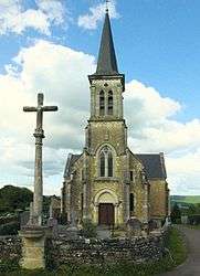 The church in Colombier | ||
| ||
 Colombier Location within Bourgogne-Franche-Comté region  Colombier | ||
| Coordinates: 47°10′07″N 4°40′29″E / 47.1686°N 4.6747°E / 47.1686; 4.6747Coordinates: 47°10′07″N 4°40′29″E / 47.1686°N 4.6747°E / 47.1686; 4.6747 | ||
| Country | France | |
| Region | Bourgogne-Franche-Comté | |
| Department | Côte-d'Or | |
| Arrondissement | Beaune | |
| Canton | Arnay-le-Duc | |
| Government | ||
| • Mayor (2008–2014) | Jean-Yves Tuffery | |
| Area1 | 3.9 km2 (1.5 sq mi) | |
| Population (2008)2 | 56 | |
| • Density | 14/km2 (37/sq mi) | |
| Time zone | UTC+1 (CET) | |
| • Summer (DST) | UTC+2 (CEST) | |
| INSEE/Postal code | 21184 /21360 | |
| Elevation |
325–544 m (1,066–1,785 ft) (avg. 520 m or 1,710 ft) | |
|
1 French Land Register data, which excludes lakes, ponds, glaciers > 1 km2 (0.386 sq mi or 247 acres) and river estuaries. 2 Population without double counting: residents of multiple communes (e.g., students and military personnel) only counted once. | ||
.svg.png)
Colombier is a commune in the Côte-d'Or department in eastern France.
Population
| Historical population | ||
|---|---|---|
| Year | Pop. | ±% |
| 1962 | 58 | — |
| 1968 | 64 | +10.3% |
| 1975 | 44 | −31.2% |
| 1982 | 45 | +2.3% |
| 1990 | 45 | +0.0% |
| 1999 | 51 | +13.3% |
| 2008 | 56 | +9.8% |
See also
References
| Wikimedia Commons has media related to Colombier (Côte-d'Or). |
This article is issued from
Wikipedia.
The text is licensed under Creative Commons - Attribution - Sharealike.
Additional terms may apply for the media files.