Madungandí
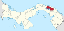
Location of Kuna de Madugandí in Panama
| Comarca Guna de Madungandí | |
|---|---|
| Corregimiento | |
| Country |
|
| Province | Panamá |
| District | Chepo |
| Established | January 12, 1996[1] |
| Area[1] | |
| • Land | 2,075.9 km2 (801.5 sq mi) |
| Population (2010)[1] | |
| • Total | 4,271 |
| • Density | 2.1/km2 (5/sq mi) |
| Population density calculated based on land area. | |
| Time zone | UTC−5 (EST) |
Guna de Madungandí or Madungandí, formerly known as Kuna de Madugandí[2] is a corregimiento in Chepo District, Panamá Province, Panama with a population of 4,271 as of 2010.[1] It was created by Law 24 of January 12, 1996.[1] Its population as of 2000 was 3,305.[1]
The primary ethnicity is Guna.
The comarca is not divided into districts; but is divided into 12 communities: Akua Yala, Ibedí, Pintupu, Icandí, Piria, Cuinupdi, Nargandí, Ogobnawila, Diwar Sikua, Capandi and Tabardi. Its capital is Akua Yala.
Its area is 2318.8 km2 and is located near the Bayano River.
References
- 1 2 3 4 5 6 "Cuadro 11 (Superficie, población y densidad de población en la República...)" [Table 11 (Area, population, and population density in the Republic...)] Archived 2016-03-04 at the Wayback Machine. (.xls). In "Resultados Finales Básicos" [Basic Final Results] (in Spanish). National Institute of Statistics and Census of Panama. Archived from the original on July 10, 2015. Retrieved May 26, 2015.
- ↑ https://m.prensa.com/impresa/opinion/Guna-kuna-cuna-James-Howe_0_3874112623.html
Capital: Panama | ||
| Balboa District |  | |
| Chepo District | ||
| Chimán District | ||
| Panamá District | ||
| San Miguelito District | ||
| Taboga District | ||
This article is issued from
Wikipedia.
The text is licensed under Creative Commons - Attribution - Sharealike.
Additional terms may apply for the media files.