Kuna de Wargandí
| Comarca Guna de Wargandí | |
|---|---|
| Comarca indígena and corregimiento | |
 | |
| Country |
|
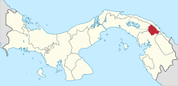
| Province | Darién |
| District | Pinogana |
| Established | July 25, 2000[1] |
| Area[1] | |
| • Land | 956.4 km2 (369.3 sq mi) |
| Population (2010)[1] | |
| • Total | 1,914 |
| • Density | 2/km2 (5/sq mi) |
| Population density calculated based on land area. | |
| Time zone | UTC−5 (EST) |
Guna de Wargandí or Wargandí, formerly known as Kuna de Wargandí[2] (Spanish pronunciation: [ˈkuna ðe waɾˈɣandi]) is a comarca indígena (indigenous territory) and corregimiento in Pinogana District, Darién Province, Panama with a population of 1,914 as of 2010.[1] It was created by Law 34 of July 25, 2000,[1] from the province of Darién, from the district of Pinogana. It has an area of 775 square kilometres (299 sq mi). It is inhabited by the Guna people.
Geography
It is a region of Guna and its status is local township, so this has no political subdivision or capital. It is located in the basin are high Chucunaque River in the territory segregated districts Pinogana Chepigana and the province of Darien. People live in three communities, Mortí, Nurra and Wala.
This comarca is not divided into districts. The community of Nurra serves as its capital.
References
- 1 2 3 4 5 "Cuadro 11 (Superficie, población y densidad de población en la República...)" [Table 11 (Area, population, and population density in the Republic...)] Archived 2016-03-04 at the Wayback Machine. (.xls). In "Resultados Finales Básicos" [Basic Final Results] (in Spanish). National Institute of Statistics and Census of Panama. Archived from the original on July 10, 2015. Retrieved May 26, 2015.
- ↑ https://m.prensa.com/impresa/opinion/Guna-kuna-cuna-James-Howe_0_3874112623.html
| Provinces | ||
|---|---|---|
Corregimiento-level Comarcas indígenas | ||