Chora District
| Chora چوره | |
|---|---|
| District | |
 | |
 Chora Location within Afghanistan | |
| Coordinates: 32°50′50″N 66°03′00″E / 32.84722°N 66.05000°ECoordinates: 32°50′50″N 66°03′00″E / 32.84722°N 66.05000°E | |
| Country |
|
| Province | Uruzgan |
| Area | |
| • Total | 3,005 km2 (1,160 sq mi) |
| Population (2006) | |
| • Total | 73,750 |
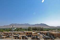
Chora District is a district of Oruzgan Province, Afghanistan.[1] The district center is the town of Chora, with a population of about 3,000. It is a rural town with no industry beyond livestock, agriculture, and small merchants.
A ribbon-cutting ceremony was held to officially open the Tarinkot to Chora Road Oct. 4, 2011. The Dutch State Secretary, Ben Knapen, along with the Uruzgan provincial governor, Mohammed Sherzad, held the ribbon-cutting ceremony to celebrate the completion of construction of the road that will better connect the Chora district to the provincial capital city by cutting travel time between the two by more than half.
District profile:[2]
- Villages: 100
- Schools: 21 primary, 2 high schools.
- Health centers: 1.
References
- ↑ "District Names". National Democratic Institute. Retrieved 1 June 2015.
- ↑ "Summary of the District Development Plan, 2006" (PDF). Trinkot District Development Assembly. Archived from the original (PDF) on 17 November 2015. Retrieved 1 June 2015.
External links
This article is issued from
Wikipedia.
The text is licensed under Creative Commons - Attribution - Sharealike.
Additional terms may apply for the media files.