Chermalyk
| Chermalyk Чермалик | ||
|---|---|---|
| Village | ||
| ||
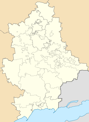 Chermalyk Location of Artema within Ukraine  Chermalyk Chermalyk (Ukraine) | ||
| Coordinates: 47°18′54″N 37°48′22″E / 47.31500°N 37.80611°ECoordinates: 47°18′54″N 37°48′22″E / 47.31500°N 37.80611°E | ||
| Country |
| |
| Province | Donetsk Oblast | |
| District | Boykivske Raion | |
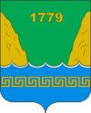
| Founded | 1779 | |
| Area | ||
| • Total | 1.75 km2 (0.68 sq mi) | |
| Elevation | 70 m (230 ft) | |
| Population (2001 census) | ||
| • Total | 1,908 | |
| • Density | 1,100/km2 (2,800/sq mi) | |
| Time zone | UTC+2 (EET) | |
| • Summer (DST) | UTC+3 (EEST) | |
| Postal code | 87142 | |
| Area code | +380 6279 | |
Chermaly′k (Ukrainian: Чермалик; Russian: Чермалык) is a village in Boykivske Raion (district) in Donetsk Oblast (province) of eastern Ukraine, near the northern banks of the Sea of Azov. Chermalyk is situated at 39.3 km south from the centre of Donetsk city, in some 40 km from Mariupol on the left bank of the Kalmius river.
Demographics
Native language as of the Ukrainian Census of 2001:[1]
References
- ↑ Розподіл населення за рідною мовою на ukrcensus.gov.ua Archived July 31, 2014, at the Wayback Machine.
External links
| Raions | |||||
|---|---|---|---|---|---|
| Cities |
| ||||
| |||||
This article is issued from
Wikipedia.
The text is licensed under Creative Commons - Attribution - Sharealike.
Additional terms may apply for the media files.