Chembur
| Chembur | |
|---|---|
| neighborhood | |
 Chembur Market | |
 Chembur | |
| Coordinates: 19°03′04″N 72°53′38″E / 19.051°N 72.894°ECoordinates: 19°03′04″N 72°53′38″E / 19.051°N 72.894°E | |
| Country | India |
| State | Maharashtra |
| District | Mumbai Suburban |
| Metro | Mumbai |
| Zone | 5 |
| Ward | M |
| Languages | |
| • Official | Marathi |
| Time zone | UTC+5:30 (IST) |
| PIN | 400071[1] |
| Area code(s) | 022 |
| Vehicle registration | MH 03 |
| Lok Sabha constituency | Mumbai South Central |
| Vidhan Sabha constituency | Chembur |
| Civic agency | BMC |
Chembur is one of the largest suburbs in eastern Mumbai, India.
Etymology
The name Chembur is likely derived from the word Chimboree, which means "Large Crab" in Marathi.
History
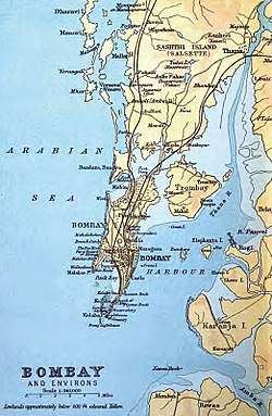
Chembur comprises large cosmopolitan residential societies of concrete buildings dating back to the early 1950s in addition to older villages such as Ghatla, Gaothan, Wadavli, Mahul, Gavanpada, Ambapada(Ambada), etc. Before reclamation, Chembur lay on the north-western corner of Trombay Island. It is suggested that Chembur is the same place referred to as Saimur by the Arab writers(915–1137), Sibor in Cosmas Indicopleustes(535), Chemula in the Kanheri cave inscriptions(300–500), Symulla by the author of the Periplus of the Erythraean Sea(247), Symulla or Timulla by Ptolemy(150), and perhaps even Perimula by Pliny(A.D. 77).[2] This is, however, disputed. Chembur is also said to be a reference to Chevul at the mouth of the Kundalika River on mainland Maharashtra. Later, the area occupied was said to have occupied a branch of an animal home.[2]
The Bombay Presidency Golf Club was established in 1827, and was later re-built to meet international standards.[3] No major activity occurred until the Kurla-Chembur single railway line was built in 1906 for garbage trains. The line was opened to passenger traffic in 1924.[4] After construction activity in the 1920s, Chembur was finally opened up in the 1930s. It was made part of Bombay City in 1945.[5]
After independence, Chembur was one of the sites where refugee camps were set up to settle refugees after partition.[6] The industrialisation of Trombay during and after World War II led to the demand for housing and the growth of Chembur thereafter.[7][8][9]
The construction by the Bombay Housing Board in Station Colony(Subhash Nagar), the Shell Colony(Sahakar Nagar), and the Township Colony(Tilak Nagar) in 1955 through to 1958 transformed the area completely by shifting it from an industrial area to a residential one.[10]
Administration
Chembur lies in the Mumbai South Central parliamentary constituency. It used to lie in Mumbai North-East Parliamentary constituency, prior to delimitation in 2008, where it was moved to Mumbai South Central parliamentary Constituency.[11] The current sitting Member of Parliament of Mumbai South Central is Shiv Sena's Rahul Shewale.[12]
The Sitting Member of the Legislative Assembly of Chembur is Mr. Prakash Vaikunth Phaterpekar of the Shiv Sena.
Chembur is the seat of the M Ward Offices. The M Ward ranges from Thane Creek in the East to Tansa Pipe Line No. 2 in the West, from Somaiyya Nalla in the North to Mahul Creek in the South.[13][14] Chembur lies inward numbers 141 to 149 with Councillors for each representing it in the Brihanmumbai Municipal Corporation.[15] [16]
Geography
Chembur is surrounded by the neighborhoods of Kurla, Deonar, Mahul, Govandi, Chunabhatti and Ghatkopar. A marine alluvium-type of soil is observed in Chembur. It has north-south running basalt hills to its south.[17]
Transport
Modes of public transport in Chembur include autorickshaws, online aggregator cabs such as Uber and Ola, taxicabs, BEST buses, NMMT buses, and trains. NMMT AC Volvo buses are available from Navi Mumbai to Mumbai and vice versa. The Harbour Line of the Mumbai Suburban Railway has a station in Chembur. Chembur is one of the four suburban railway stations chosen for revamping by the Mumbai Rail Vikas Corporation (MRVC). Suburban trains bound for Mumbai CST, Andheri, and Panvel run throughout the day. The Lokmanya Tilak Terminus for long distance trains is located nearby. Line 1 of Mumbai Monorail opened in February 2014 and has a terminus at Chembur. This line connect Chembur to Wadala. This line of the monorail is being extended until Jacob Circle in South Mumbai and is likely to be operational by mid 2018. Metro Line 2B is an under construction metro line in the city of Mumbai connecting Dahisar in the northwest with Mandale in Mankhurd in the east via Bandra, BKC and Chembur ( a station is planned in the Diamond Garden area in Chembur).
Dayanand Saraswati Marg, V N Purav Marg, R C Marg, Station Avenue Road, the Eastern Express Highway and Sion Panvel Highway are some of the arterial roads of Chembur. Chembur is a road transit point for people traveling to Pune using the Mumbai-Pune Highway or the Mumbai-Pune Expressway. The Eastern Freeway provides quick access to South Mumbai through 13-km-long elevated expressway. The Santacruz Chembur Link Road (SCLR) connects Chembur to Santacruz.
Dayanand Saraswati Marg
Dayanand Saraswati Marg stretches from Chembur Railway Station to Sion Panvel Highway, formerly and commonly called Central Avenue Road. It is lined on both sides mainly with residential complexes and shade trees. In 2008, the height of the road was raised and provided with a sidewalk.[18] The Central Avenue Road is a prime locality in Chembur.[19] This road is important since it connects most of Chembur (West) to the Chembur Railway station, an important mode of transit. The Ambedkar Garden bus depot on this route also connects people to downtown Mumbai. It also has the Chembur Railway Police Station, hospitals, medical shops, eateries and various commercial establishments. Dayanand Saraswati Marg is a 4 lane bidirectional road with sidewalks on both sides of the road. There are two turnabouts; one each at Ambedkar Garden and Diamond Garden. The Dayanand Saraswati Marg near the Railway Station junction meets the Chembur Market Road and Govandi Road. The following roads branch off from this road:
- Chembur Road Nos. 21, 19, 16, 15, 14, 13, 12, 11, 10, 7, 5
- St. Anthony's Road
This road, formerly called Central Avenue Road, was given its current name in memory of Dayanand Saraswati.
Economy
Chembur is home to many industry and retail outlets.
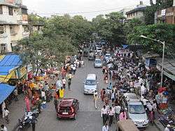
The Chembur Market area close to the Chembur railway station offers goods and services ranging from clothing to foods and vegetables. In addition, it has retail and factory outlets, multi-product stores and a shopping mall. Chembur offers a variety of food from street food to high end restaurants. Chembur is known for its misal pav, pav bhaji, vada pav and also sweet marts.
Recreation
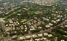
Chembur has open public spaces like Gandhi Maidan,[20] Annabhau Sathe Garden, Diamond Garden,[21] Ambedkar Udyan, Sandu Garden, Tilak Nagar grounds (Sahyadri and Municipal Ground) and Jawahar Grounds where people conduct sports events and activities. These are also sites of recreational activity in the morning.
The Bombay Presidency Golf Club at Dr Choitram Gidwani Road in Chembur (East) provides the biggest green cover for the neighbourhood. Chembur has recreational clubs along with several Gymkhanas. Chembur has fitness centres and gyms, municipal swimming pools, libraries and Sports club like Kreeda Sankul in RCF Colony Some grounds have jogging tracks for people to exercise.
Environmental problems
Chembur has pollution problems and was ranked 46th in a list of the most polluted industrial clusters in India.[22] Studies of Chembur have also found high levels of copper, chromium, calcium, arsenic and mercury in ground water.[17] Effluents from oil refineries, fertilizer plants and reactors in Chembur are also said to have polluted sea water in Thane Creek and affected marine life.[17]
The main problem is the uncontrolled release of ammonia and nitrous oxides from the Rashtriya Chemicals & Fertilisers (RCF) complex. Although ammonia is easy to scrub, the problem seems to be due to improper operation of pollution control equipment and/or operation of the urea/ammonia complex way beyond the design capacity without augmentation of pollution control equipment.
The Deonar dumping ground in Deonar has caused health issues for the residents of Chembur.[23] In 2008, around 40 residents of Chembur went on a hunger strike to protest against the frequent fires and smoke.[24] Again in 2012, the residents complained to the Brihanmumbai Municipal Corporation on the smoke coming out of the dumping ground, which has been affecting asthma patients.[25]
See also
Footnotes
- ↑ "Pin code : Chembur, Mumbai". pincode.org.in. Retrieved 10 February 2015.
- 1 2 Archived 15 June 2011 at the Wayback Machine.
- ↑ Times of India - Chembur Ghatkopar Plus - "Archived copy". Archived from the original on 2011-07-14. Retrieved 2010-12-03. - Retrieved on 3 December 2010
- ↑ "History of Railways in India - Part 3". IRFCA. Retrieved 15 May 2010.
- ↑ TIFR Mumbai pages - http://theory.tifr.res.in/bombay/physical/geo/ghatkopar.html - Retrieved on 5 December 2010
- ↑ Indian Express - "Archived copy". Archived from the original on 2010-04-19. Retrieved 2010-12-03. - Retrieved on 3 December 2010
- ↑ TIFR Mumbai Pages - http://theory.tifr.res.in/bombay/physical/geo/mankhurd.html
- ↑ "Sorry". The Indian Express. Retrieved 10 October 2012.
- ↑ "Disaster is around the corner for Mumbai". DNA India. 26 December 2006. Retrieved 10 October 2012.
- ↑ "History of Chembur".
- ↑ "Delimitation of Parliamentary and Assembly Constituencies Order - 2008" (PDF).
- ↑ "Constituencywise-All Candidates".
- ↑ "M West limits".
- ↑ "M East limits(includes Mankhurd and Govandi - excluded here)".
- ↑ "MCGM Councillors list".
- ↑ "Page Not Found". eciresults.nic.in.
- 1 2 3 Central Ground Water Board Report - Ground Water Information 2009 - http://cgwb.gov.in/District_Profile/Maharashtra/Greater%20Mumbai.pdf - Accessed on 20 January 2011
- ↑ "BMC slammed for failing rain test". The Times of India. 7 July 2006. Retrieved 8 June 2018.
- ↑ Mid-Day - http://www.mid-day.com/metro/2003/sep/64082.htm - Retrieved on 5 December 2010
- ↑ S Balakrishnan, Times News Network (13 November 2008). "PM to kickstart monorail project from Gandhi Maidan". The Times of India. Mumbai. Retrieved 24 May 2012.
- ↑ Davane, Mrugaya (16 June 2006). "Chembur will always be our home". MiD DAY. Mumbai. Retrieved 24 May 2012.
- ↑ Gyan Varma (25 December 2009) "43 Industrial Clusters imperiled in India", Daily News and Analysis. Accessed on 25 January 2011
- ↑ "45% of Deonar dumping ground to be cleared by May". DNA India. 28 March 2011. Retrieved 24 May 2012.
- ↑ "Residents protest fire at Deonar dumping ground". The Indian Express. 25 March 2008. Archived from the original on 31 July 2012. Retrieved 24 May 2012.
- ↑ Times News Network (18 May 2012). "Chembur residents fume over smoke from Deonar dumping ground". The Times of India. Mumbai. Retrieved 18 May 2012.
External links
| Wikimedia Commons has media related to Chembur. |
- BEST public buses route search