Bentonville Battlefield
|
Bentonville Battlefield | |
 | |
 | |
| Location | Johnston County, North Carolina |
|---|---|
| Coordinates | 35°18′23″N 78°19′26″W / 35.30639°N 78.32389°WCoordinates: 35°18′23″N 78°19′26″W / 35.30639°N 78.32389°W |
| Area |
6,500 acres (10.2 sq mi; 26 km2) (landmarked battlefield area) 130 acres (53 ha) (state historic site area) |
| Built | 1957 |
| NRHP reference # | 70000460 |
| Significant dates | |
| Added to NRHP | February 26, 1970[1] |
| Designated NHL | June 19, 1996[2] |
Bentonville Battlefield is a North Carolina state historic site at 5466 Harper House Road in Johnston County, North Carolina. It belongs to the North Carolina Department of Natural and Cultural Resources and is the site of the 1865 Battle of Bentonville, fought in the waning days of the American Civil War. It was declared a National Historic Landmark in 1996.[2][3]
Description and history
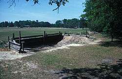
The Bentonville Battlefield is located in southern Johnston County, roughly midway between Newton Grove and Bentonville. The visitors center is located at the junction of Harper House Road and Mill Creek Church Road (County Roads 1008 and 1108, respectively). It is roughly at the southwestern corner of the area in which the battle took place, which extends most of the way to Bentonville, and is also the location of the Harper House, the only surviving building from the time of the battle. Evidence of earthworks erected by both Union and Confederate forces is visible in the agricultural fields in this area.[3]
The Battle of Bentonville was fought March 19–21, 1865, and was the largest Civil War battle fought in North Carolina. The Confederate defeat marked a serious weakening of one of its last surviving major armies, but was a significant enough engagement that it convinced Union General Ulysses S. Grant to leave General William T. Sherman in North Carolina, in order to further subdue the surviving forces led by General Joseph E. Johnston.[3]
The Civil War Trust (a division of the American Battlefield Trust) and its partners have acquired and preserved 1,861 acres (7.53 km2) of the battlefield in more than 50 different acquisitions since 1960. Most of the land is now owned by the state.[4]
Exhibits
Visitors to the Bentonville Battlefield can tour the restored Harper House, which has been furnished as a Civil War field hospital, and includes a reconstructed kitchen and slave quarters. Exhibits at the park's visitor center focus on the battle, and include interactive maps, artifacts and displays about soldiers and commanders from both armies.[5] There is also a 10-minute audiovisual program about the battle. Outdoor exhibits in the park include the Federal XX Corps reserve trenches, the Harper family cemetery, a Confederate mass grave, several monuments and a field fortification exhibit.[6]
See also
References
- ↑ National Park Service (2007-01-23). "National Register Information System". National Register of Historic Places. National Park Service.
- 1 2 "Bentonville Battleground". National Historic Landmark summary listing. National Park Service. Archived from the original on 2007-03-02. Retrieved 2008-02-18.
- 1 2 3 John Goode; Paul Hawke; James H. Charleton & Patty Henry (November 22, 1994). "National Register of Historic Places Inventory-Nomination: Bentonville Battlefield" (pdf). National Park Service. and Accompanying 4 photos, undated (32 KB)
- ↑ American Battlefield Trust "Saved Land" webpage. Accessed May 24, 2018.
- ↑ http://www.nchistoricsites.org/bentonvi/fiber-optic.htm New Exhibits
- ↑ http://www.nchistoricsites.org/bentonvi/facilities.htm Facilities
External links
- Bentonville Battlefield
- Bentonville Battleground State Historic Site - official site
- The Battle of Bentonville: Caring for Casualties of the Civil War, a National Park Service Teaching with Historic Places (TwHP) lesson plan

