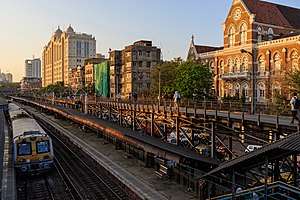
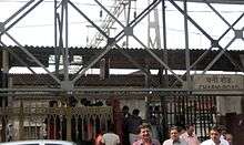
Charni Road railway station
| Mumbai Suburban Railway station | |||||||||||
 | |||||||||||
| Coordinates | 18°57′06″N 72°49′07″E / 18.951565°N 72.818633°ECoordinates: 18°57′06″N 72°49′07″E / 18.951565°N 72.818633°E | ||||||||||
| Owned by | Ministry of Railways, Indian Railways | ||||||||||
| Line(s) | Western Line | ||||||||||
| Platforms | 4 | ||||||||||
| Tracks | 4 | ||||||||||
| Construction | |||||||||||
| Structure type | Standard on-ground station | ||||||||||
| Other information | |||||||||||
| Fare zone | Western Railways | ||||||||||
| History | |||||||||||
| Opened | 1867 | ||||||||||
| Services | |||||||||||
| |||||||||||
| Location | |||||||||||
 Charni Road Location within Mumbai | |||||||||||
Charni Road (Old spellings: Churney Road and Charney Road)[1] is a railway station on the Western Line of the Mumbai Suburban Railway. The main significance of Charni Road station is that it is near the Girgaum Chowpatti beach and Marine Drive promenade, a major destination for tourists in Mumbai. It is also important because of the diamond trading industry located here, mainly in the Panchratna and Prasad chambers building near the railway station.
The station derives its name from the fact that grazing lands for cattle and horses were located nearby in earlier days (Charne in Marathi means to graze).[2] In 1838, the British rulers introduced a 'grazing fee' which several cattle-owners could not afford. Therefore, Sir Jamshedji Jeejeebhoy spent ₹20,000 from his own purse for purchasing some grasslands near the seafront at Thakurdwar and saw that the starving cattle grazed without a fee in that area. In time the area became to be known as "Charni" meaning grazing. When a railway station on the BB&CI railway was constructed there it was called Charni Road. The BB&CI line from Back Bay to Virar opened in 1867.[3]
There have also been some controversies during its renovation.[4]
Today Charni road is well known for its old charm Chawls, wholesale markets of diamonds (Opera House), garments, Irani cafés traditional Maharashtrian culture (Girgaon) and also tall skyscrapers. Also the famous Hinduja College of commerce and economics have been set up by Hinduja group in 1974.This college ranks 3rd in Mumbai and 25th all over India.
For information about the area, see Charni Road.
References
- ↑ D'Cunha, Jose Gerson (1900). "IV The Portuguese Period". The Origins of Bombay (3 ed.). Bombay: Asian Educational Services. p. 212. ISBN 81-206-0815-1. Retrieved 2008-12-29.
- ↑ "As recent demands in Mumbai show, battles over station names never seem to end". The Economic Times. Retrieved 17 March 2017.
- ↑ Eastern Economist. 64. R.P. Agarwala. 1975. p. 170.
- ↑ "Tile construction". Mid Day. Retrieved 2014. Check date values in:
|accessdate=(help)
External links
