Kureelpa, Queensland
| Kureelpa Queensland | |||||||||||||||
|---|---|---|---|---|---|---|---|---|---|---|---|---|---|---|---|
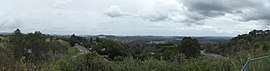 Kureelpa panorama, 2015 | |||||||||||||||
 Kureelpa | |||||||||||||||
| Coordinates | 26°36′24″S 152°53′34″E / 26.6066°S 152.8927°ECoordinates: 26°36′24″S 152°53′34″E / 26.6066°S 152.8927°E | ||||||||||||||
| Postcode(s) | 4560 | ||||||||||||||
| Area | 15.3 km2 (5.9 sq mi) | ||||||||||||||
| LGA(s) | Sunshine Coast Region | ||||||||||||||
| State electorate(s) | Nicklin | ||||||||||||||
| Federal Division(s) | Fairfax | ||||||||||||||
| |||||||||||||||
Kureelpa is a locality in the Sunshine Coast Region, Queensland, Australia.[1]
History
The name Kureelpa is reportedly derived from an Aboriginal name, Kuril-ba, meaning a place of rats and mice.[1]
Kureelpa Provisional School opened on 24 February 1914, becoming Kureelpa State School on 1 June 1916. The school closed on 1 December 1967.[2]
References
- 1 2 "Kureelpa - locality in Sunshine Coast Region (entry 48715)". Queensland Place Names. Queensland Government. Retrieved 6 August 2017.
- ↑ Queensland Family History Society (2010), Queensland schools past and present (Version 1.01 ed.), Queensland Family History Society, ISBN 978-1-921171-26-0
External links
![]()
- "Kureelpa". Queensland Places. Centre for the Government of Queensland, University of Queensland.
This article is issued from
Wikipedia.
The text is licensed under Creative Commons - Attribution - Sharealike.
Additional terms may apply for the media files.