North Maleny, Queensland
| North Maleny Queensland | |||||||||||||||
|---|---|---|---|---|---|---|---|---|---|---|---|---|---|---|---|
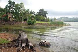 Lake Baroon, 2008 | |||||||||||||||
 North Maleny | |||||||||||||||
| Coordinates | 26°43′34″S 152°52′23″E / 26.7261°S 152.8730°ECoordinates: 26°43′34″S 152°52′23″E / 26.7261°S 152.8730°E | ||||||||||||||
| Postcode(s) | 4552 | ||||||||||||||
| Area | 26.1 km2 (10.1 sq mi) | ||||||||||||||
| LGA(s) | Sunshine Coast Region | ||||||||||||||
| State electorate(s) | Glass House | ||||||||||||||
| Federal Division(s) | Fisher | ||||||||||||||
| |||||||||||||||
North Maleny is a locality in the Sunshine Coast Region, Queensland, Australia.[1]
Geography
The Baroon Pocket Dam is in the north-east of the locality; it impounds Obi Obi Creek creating Lake Baroon.[2]
History
The Maleny Provisional School opened on 22 July 1897, becoming Maleny State School on 1 January 1909. It was renamed Maleny North State School in 1913 (probably because of the opening on Maleny Township State School in nearby Maleny) but closed in 1914. On 27 February 1922 it reopened as Maleny North Provisional School, becoming Maleny North State School on 4 July 1927. It finally closed in 1953.[3]
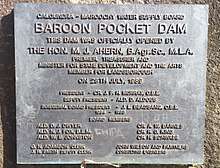
The Baroon Pocket Dam was officially opened by Queensland Premier Mike Ahern on 28 July 1989.[4]
References
- ↑ "North Maleny - locality in Sunshine Coast Region (entry 48814)". Queensland Place Names. Queensland Government. Retrieved 12 September 2017.
- ↑ "Queensland Globe". State of Queensland. Retrieved 12 September 2017.
- ↑ Queensland Family History Society (2010), Queensland schools past and present (Version 1.01 ed.), Queensland Family History Society, ISBN 978-1-921171-26-0
- ↑ "Baroon Pocket Dam". SEQ Water. Archived from the original on 12 September 2017. Retrieved 12 September 2017.
External links
![]()