Flaxton, Queensland
| Flaxton Queensland | |||||||||||||||
|---|---|---|---|---|---|---|---|---|---|---|---|---|---|---|---|
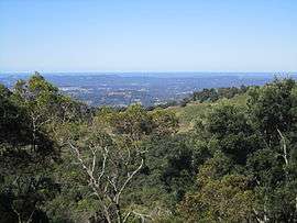 View from Flaxton towards the Pacific Ocean | |||||||||||||||
| Population | 931 (2016 census)[1] | ||||||||||||||
| Postcode(s) | 4560 | ||||||||||||||
| LGA(s) | Sunshine Coast Region | ||||||||||||||
| State electorate(s) | Glass House | ||||||||||||||
| Federal Division(s) | Fairfax | ||||||||||||||
| |||||||||||||||
Flaxton is a rural locality in the Sunshine Coast Region, Queensland, Australia.[2] At the 2016 Australian Census the locality recorded a population of 931.[1]
History
The locality is named after Flaxton Hall Farm in the fens of Eastern England.[2] Joseph Dixon, who originally grew sugarcane at Buderim, selected land at Flaxton in 1882.[3] From 1892 the land was cleared so bananas and citrus fruit could be farmed.
A fruit-packing shed which could process the district's entire harvest was opened 1931.[3] A sawmill operated for more than 20 years before being burned down in 1956.[3]
Flaxton State School was established in 1967.[4]
References
- 1 2 Australian Bureau of Statistics (27 June 2017). "Flaxton (State Suburb)". 2016 Census QuickStats. Retrieved 25 March 2018.

- 1 2 "Flaxton (entry 47199)". Queensland Place Names. Queensland Government. Retrieved 14 March 2014.
- 1 2 3 Environmental Protection Agency (Queensland) (2000). Heritage Trails of the Great South East. State of Queensland. p. 133. ISBN 0-7345-1008-X.
- ↑ "D-F". Opening and closing dates of Queensland schools. Queensland Government. Retrieved 14 March 2014.
External links
- "Flaxton". Queensland Places. Centre for the Government of Queensland, University of Queensland.
Coordinates: 26°39′33″S 152°52′09″E / 26.65917°S 152.86917°E
This article is issued from
Wikipedia.
The text is licensed under Creative Commons - Attribution - Sharealike.
Additional terms may apply for the media files.