| Image |
[1] |
Landmark name |
Location |
City or town |
Summary |
|---|
 |
47 |
Anza Expedition Camp |
Banks of San Mateo Camp
|
San Mateo |
|
|
48 |
Anza Expedition Camp |
El Camino Real and Ralston
|
Burlingame |
|
|
19 |
Broderick-Terry Dueling Place |
1100 Lake Merced Blvd.
37°42′29″N 122°29′03″W / 37.708167°N 122.484167°W / 37.708167; -122.484167 (Broderick-Terry Dueling Place) |
Daly City |
|
|
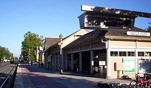
846 |
Burlingame Station |
290 California Dr.
37°34′48″N 122°20′42″W / 37.58°N 122.345°W / 37.58; -122.345 (Burlingame Station) |
Burlingame |
Also on the NRHP list as NPS-78000769 |
|
939 |
Capidro |
262 Princeton Rd.
|
Menlo Park |
Folk art ornamenting a Menlo Park home, no longer exists. |
|
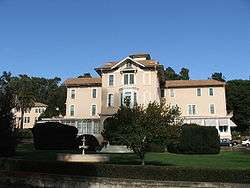
886 |
Carolands |
565 Remillard Rd.
37°33′20″N 122°22′15″W / 37.5555°N 122.37075°W / 37.5555; -122.37075 (Carolands) |
Hillsborough |
Also on the NRHP list as NPS-75000478 |
|
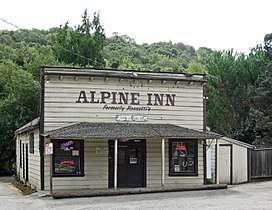
825 |
Casa de Tableta |
3915 Alpine Rd.
37°22′56″N 122°11′37″W / 37.382222°N 122.193611°W / 37.382222; -122.193611 (Casa de Tableta) |
Portola Valley |
Also called Alpine Inn, on the NRHP list as NPS-73000447 |
|
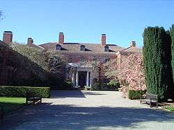
907 |
Filoli |
Filoli Center, Canada Rd.
37°28′13″N 122°18′39″W / 37.4704°N 122.310703°W / 37.4704; -122.310703 (Filoli) |
Woodside |
|
|
949 |
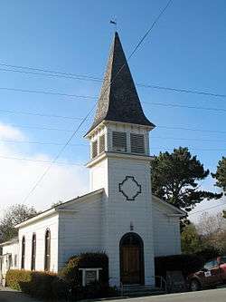
First Congregational Church of Pescadero |
San Gregorio St.
37°15′16″N 122°23′00″W / 37.25455°N 122.383333°W / 37.25455; -122.383333 (First Congregational Church of Pescadero) |
Pescadero |
|
|
955 |
Menlo Park Station |
1120 Merrill St.
37°27′17″N 122°10′51″W / 37.454722°N 122.180833°W / 37.454722; -122.180833 (Menlo Park Station) |
Menlo Park |
Also on the NRHP list as NPS-74000556 |
|
393 |
Mission Hospice |
Baywood and El Camino Real
37°33′55″N 122°19′41″W / 37.565383°N 122.328067°W / 37.565383; -122.328067 (Mission Hospice) |
San Mateo |
|
|
343 |
Old Store at La Honda |
Northwest corner, La Honda Road and Sears Ranch Road
|
La Honda |
Building no longer exists. |
|
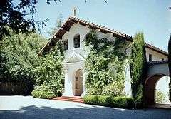
909 |
Our Lady of the Wayside Church |
930 Portola Rd.
37°23′02″N 122°14′02″W / 37.3839°N 122.2338°W / 37.3839; -122.2338 (Our Lady of the Wayside Church) |
Portola Valley |
|
|
930 |
Pigeon Point Lighthouse |
37°10′54″N 122°23′38″W / 37.181667°N 122.393889°W / 37.181667; -122.393889 (Pigeon Point Lighthouse) |
Davenport |
|
|
22 |
Portolà Expedition Camp |
Mouth of Purisima Creek
|
Half Moon Bay |
|
|
23 |
Portolà Expedition Camp |
Mouth of Gazos Creek
|
Pescadero |
|
|
24 |
Portolà Expedition Camp |
Mouth of San Pedro Creek
|
Pacifica |
|
|
25 |
Portolà Expedition Camp |
Foot of Montara Mountain
|
|
|
|
26 |
Portolà Expedition Camp |
San Gregorio State Beach
37°19′23″N 122°24′07″W / 37.323056°N 122.401944°W / 37.323056; -122.401944 (Portolà Expedition Camp) |
San Gregorio |
|
|
27 |
Portolà Expedition Camp |
Upper Crystal Springs Reservoir
|
|
|
|
92 |
Portolà Expedition Camp |
Pulgas Water Temple
|
Woodside |
|
|
94 |
Portolà Expedition Camp |
Upper Crystal Springs Reservoir
|
San Mateo |
|
|
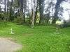
2 |
Portolà Journey's End |
E. Creek Dr. and Alma St.
|
Menlo Park |
|
|
856 |
Ralston Hall |
College of Notre Dame, 1500 Ralston Ave
37°31′03″N 122°17′10″W / 37.5175°N 122.286111°W / 37.5175; -122.286111 (Ralston Hall) |
Belmont |
Also on the NRHP list as NPS-66000234 |
|
391 |
Sánchez Adobe |
Sánchez Adobe Park
37°35′15″N 122°29′33″W / 37.5875°N 122.4925°W / 37.5875; -122.4925 (Sánchez Adobe) |
Pacifica |
Also on the NRHP list as NPS-76000525 |
|
394 |
San Francisco Bay Discovery Site |
Sweeney Ridge
37°36′16″N 122°27′28″W / 37.604444°N 122.457778°W / 37.604444; -122.457778 (San Francisco Bay Discovery Site) |
Pacifica |
Also on the NRHP list as NPS-68000022 |
|
478 |
San Mateo County's first sawmill |
Portola Rd.
37°24′18″N 122°15′19″W / 37.405133°N 122.25535°W / 37.405133; -122.25535 (San Mateo County's first sawmill) |
Woodside |
|
|
474 |
Searsville |
Sandhill and Portola Rds.
37°24′10″N 122°14′43″W / 37.40265°N 122.24525°W / 37.40265; -122.24525 (Searsville) |
Woodside |
|
|
906 |
Steele Brothers Dairy Ranches |
Año Nuevo State Reserve
|
Woodside |
|
|
934 |
Tanforan Assembly Center |
Tanforan Park Shopping Center
37°38′10″N 122°25′09″W / 37.63625°N 122.419183°W / 37.63625; -122.419183 (Tanforan Assembly Center) |
San Bruno |
|
|
375 |
Tunitas Beach, Indian Village Site |
Mouth of Tunitas Creek at Tunitas Beach
|
Half Moon Bay |
|
|
816 |
Union Cemetery |
El Camino Real and Woodside Rd.
37°28′26″N 122°13′23″W / 37.474°N 122.223°W / 37.474; -122.223 (Union Cemetery) |
Redwood City |
Also on the NRHP list as NPS-83001237 |
|
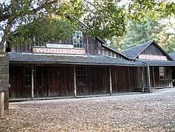
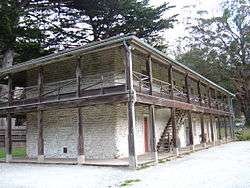
93 |
Woodside Store |
471 Kings Mountain Rd.
37°25′50″N 122°16′38″W / 37.430517°N 122.277183°W / 37.430517; -122.277183 (Woodside Store) |
Woodside |
|


.JPG)