Bryan, Texas
| Bryan, Texas | |
|---|---|
| City | |
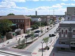 Downtown Bryan, 2009 | |
| Nickname(s): The Good Life, Texas Style | |
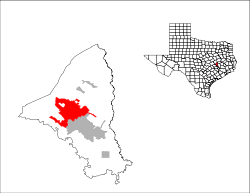 Location in the state of Texas | |
| Coordinates: 30°39′56″N 96°22′0″W / 30.66556°N 96.36667°WCoordinates: 30°39′56″N 96°22′0″W / 30.66556°N 96.36667°W | |
| Country |
|
| State |
|
| County | Brazos |
| Incorporated | 1871 |
| Government | |
| • Type | Council-Manager |
| • City Council | Mayor Andrew Nelson |
| • City Manager | Kean Register |
| Area | |
| • Total | 44.5 sq mi (115.3 km2) |
| • Land | 44.4 sq mi (115.0 km2) |
| • Water | 0.08 sq mi (0.2 km2) |
| Elevation | 374 ft (114 m) |
| Population (2017) | |
| • Total | 84,637 |
| • Density | 1,900/sq mi (730/km2) |
| Time zone | UTC−6 (CST) |
| • Summer (DST) | UTC−5 (CDT) |
| ZIP codes | 77801-03, 77807-08 |
| Area code(s) | 979 |
| FIPS code | 48-10912[1] |
| GNIS feature ID | 1353099[2] |
| Website |
www |
Bryan is a city in Brazos County, Texas, United States. As of the 2010 census, the city had a population of 76,201.[3] As of May 2017, the estimated population was 84,637. It is the county seat of Brazos County[4] and is located in the heart of the Brazos Valley (southeast Central Texas). It borders the city of College Station, which lies to its south. Together they are referred to as the Bryan–College Station metropolitan area, which has a population of more than 250,000.
History
The area around Bryan was part of a land grant to Moses Austin by Spain. Austin's son, Stephen F. Austin, helped bring settlers to the area. Among the settlers was William Joel Bryan, the nephew of Stephen Austin. In 1866 the county seat of Brazos County was changed from Boonville to Bryan, and a post office was opened. In 1867, after many delays caused by the Civil War, the Houston and Texas Central Railroad, which had only previously gotten as far as Millican, finally reached Bryan. A short time later, in 1871, the city of Bryan became incorporated. Just south of Bryan, Texas A&M College opened in 1876 in what later would be known as College Station. The following year, 1877 saw the establishment of the Bryan Independent School District. Keeping up with progress in the rest of the country, Bryan added electric lighting and a waterworks to its community in 1889. The fifth Brazos County courthouse was built in 1892, and by the turn of the century, in 1900, the International-Great Northern Railroad stopped in Bryan.
Using a generous grant of $10,000 from Andrew Carnegie, the Carnegie Library of Bryan opened its doors in 1902. In 1910 the town built an interurban railroad to College Station. By 1923 the line was abandoned. The first Jewish place of worship, the Temple Freda synagogue, was opened in 1913.[5] During the 1930s the town of North Oakwood merged with Bryan. Now Bryan and College Station are "twin" cities. In 1936 State Highway 6 was built, running right through town.
In 2006 the Texas A&M University System announced that the new Texas A&M Health Science Center campus would be built in Bryan near the new Traditions Golf Course development.
A fire at the El Dorado Chemical Co. in 2009 caused the evacuation of 70,000 residents due to the burning of ammonium nitrate, possibly causing minor respiratory problems.[6] However, the city requested that only "anyone who can smell smoke or see smoke to evacuate their homes and businesses" and did not enforce an evacuation except for 500 homes in the nearby vicinity of the fire.[7][8] Less than 1,000 residents chose to evacuate, taking shelter at Texas A&M University, which closed its campus for the day to ease traffic problems. City fire officials chose to let the fire burn down before tackling it, since the chemicals were water reactive.[7][9][10] The evacuation, which started at 2:30 pm CST ended at 7 pm, except for a small, defined area immediately around the fire, where approximately 100 Bryan residents lived.[9] In the end, only 500 residents were under a mandatory evacuation, and 35 people were treated for respiratory problems from the smoke. Officials from El Dorado said there was never any danger from the smoke or fire. The warehouse, valued at just under $1 million, was destroyed.[8]
In 2010 the Brazos County District Attorney's Office started the enforcement of a "Gang Safety Zone" in response to an escalation in violence within Bryan. Major US papers and ABC News covered this move. Cities like Houston and Los Angeles looked to the Bryan model of safety enforcement surrounding gang violence. The injunction declared a 3.2-mile (5.1 km) area in Bryan as the Gang Safety Zone. This placed about half of downtown in the area.[11]
In 2013 the Planned Parenthood clinic in Bryan closed as a result of state budget cuts which impacted family-planning facilities. The facility began offering abortions in 1998; it was one of three in the state which ceased operations on August 31, 2013.[12]
Geography
Bryan is located northwest of the center of Brazos County at 30°39′56″N 96°22′00″W / 30.665547°N 96.366745°W (30.665547, −96.366745).[13] It is bordered to the southeast by the city of College Station and to the northwest by the unincorporated community of Lake Bryan. According to the United States Census Bureau, the city has a total area of 44.5 square miles (115.3 km2), of which 44.4 square miles (115.0 km2) is land and 0.077 square miles (0.2 km2), or 0.20%, is water.[3]
The city is centrally located, approximately equidistant from three of the 10 largest cities in the United States. It is 95 miles (153 km) northwest of Houston, 166 miles (267 km) northeast of San Antonio and 166 miles (267 km) south of Dallas. It is 102 miles (164 km) east of Austin, the state capital.
Climate
The local climate is subtropical and temperate and winters are mild with periods of low temperatures usually lasting less than two months. Snow and ice are extremely rare. Summers are warm and hot with occasional showers being the only real variation in weather.
| Climate data for Bryan, Texas | |||||||||||||
|---|---|---|---|---|---|---|---|---|---|---|---|---|---|
| Month | Jan | Feb | Mar | Apr | May | Jun | Jul | Aug | Sep | Oct | Nov | Dec | Year |
| Record high °F (°C) | 86 (30) |
99 (37) |
94 (34) |
94 (34) |
100 (38) |
104 (40) |
109 (43) |
108 (42) |
106 (41) |
98 (37) |
89 (32) |
86 (30) |
109 (43) |
| Average high °F (°C) | 61 (16) |
66 (19) |
73 (23) |
79 (26) |
85 (29) |
92 (33) |
96 (36) |
96 (36) |
91 (33) |
82 (28) |
71 (22) |
63 (17) |
80 (27) |
| Average low °F (°C) | 40 (4) |
44 (7) |
50 (10) |
57 (14) |
65 (18) |
72 (22) |
74 (23) |
73 (23) |
69 (21) |
59 (15) |
49 (9) |
42 (6) |
58 (14) |
| Record low °F (°C) | 7 (−14) |
14 (−10) |
17 (−8) |
28 (−2) |
42 (6) |
53 (12) |
58 (14) |
60 (16) |
44 (7) |
29 (−2) |
19 (−7) |
2 (−17) |
2 (−17) |
| Average precipitation inches (mm) | 3.32 (84.3) |
2.38 (60.5) |
2.84 (72.1) |
3.20 (81.3) |
5.05 (128.3) |
3.79 (96.3) |
1.92 (48.8) |
2.63 (66.8) |
3.91 (99.3) |
4.22 (107.2) |
3.18 (80.8) |
3.23 (82) |
39.67 (1,007.6) |
| Source: weather.com[14] | |||||||||||||
Demographics
| Historical population | |||
|---|---|---|---|
| Census | Pop. | %± | |
| 1890 | 2,979 | — | |
| 1900 | 3,589 | 20.5% | |
| 1910 | 4,132 | 15.1% | |
| 1920 | 6,307 | 52.6% | |
| 1930 | 7,814 | 23.9% | |
| 1940 | 11,842 | 51.5% | |
| 1950 | 18,072 | 52.6% | |
| 1960 | 27,542 | 52.4% | |
| 1970 | 33,719 | 22.4% | |
| 1980 | 44,337 | 31.5% | |
| 1990 | 55,002 | 24.1% | |
| 2000 | 65,660 | 19.4% | |
| 2010 | 76,201 | 16.1% | |
| Est. 2016 | 83,260 | [15] | 9.3% |
| U.S. Decennial Census | |||
As of the census[1] of 2000, there were 65,660 people, 23,759 households, and 14,873 families residing in the city. The population density was 1,515.2 people per square mile (584.9/km2). There were 25,703 housing units at an average density of 593.1 per square mile (229.0/km2). The racial makeup of the city was 64.65% White, 17% African American, 0.40% Native American, 1.65% Asian, 0.08% Pacific Islander, 13.32% from other races, and 2.17% from two or more races. Hispanic or Latino of any ethnicity/nationality were 17.83% of the population.
There were 23,759 households out of which 32.3% had children under the age of 18 living with them, 44.2% were married couples living together, 14.0% had a female householder with no husband present, and 37.4% were non-families. 26.1% of all households were made up of individuals and 7.7% had someone living alone who was 65 years of age or older. The average household size was 2.65 and the average family size was 3.27.
In the city, the population was spread out with 27.0% under the age of 18, 18.1% from 18 to 24, 29.8% from 25 to 44, 15.8% from 45 to 64, and 9.3% who were 65 years of age or older. The median age was 28 years. For every 100 females, there were 99.2 males. For every 100 females age 18 and over, there were 95.7 males.
The median income for a household in the city was $31,672, and the median income for a family was $41,433. Males had a median income of $29,780 versus $22,428 for females. The per capita income for the city was $15,770. About 15.5% of families and 22.3% of the population were below the poverty line, including 27.0% of those under age 18 and 11.7% of those age 65 or over.
Government
State
The Texas Department of Criminal Justice (TDCJ) operates the Hamilton Unit, a pre-release facility in Bryan.[16] Hamilton opened as an adult prison facility. It was renovated for juveniles and, in mid-1997,[17] re-opened as the Texas Youth Commission (TYC) J.W. Hamilton Jr. State School. On June 15, 2003, the facility was transferred back to the TDCJ.[18] The TDCJ also operates the Bryan District Parole Office in nearby College Station.[19]
Federal
The United States Postal Service operates the Bryan and Downtown Bryan post offices.[20][21] The Federal Bureau of Prisons operates the Federal Prison Camp, Bryan, a women's prison, is located in Bryan.[22]
Economy
Major employers include:
- Texas A&M University (located in College Station, Texas) (~19,000 employees)
- Bryan Independent School District (~2,200 employees)[23]
- Sanderson Farms (~1,400 employees)
- St. Joseph Regional Health Center (~1,600 employees)
- City of Bryan (887 employees)[24]
- Alenco (~500 employees)
The Messina Hof Winery and Resort opened in the late 1970s on Old Reliance Road in eastern Bryan. In 2017, the winery launched its Vineyard District subdivision in which homeowners will be encouraged to cultivate grapes in their yards. Winery co-founders Paul and Merrill Bonarrigo own thirty-three lots on forty-eight acres which are available for development. At the time the Bonarrigos founded Messina Hof, the winery was the only development in the area. Then a winery in Austin developed a subdivision where the residents base their community activity on the winery itself. Vineyard District houses will be based on the "homes for a lifetime" concept, with emphasis on entertainment and cooking and ease of use for older adults and those physically limited. The Bonarrigos hope to bring this concept to Bryan and College Station.[25]
Sports
- Football: Kyle Field (largest crowd: 104,728)
- Football: Merrill Green Stadium (capacity 11,800)
- Racing: Texas World Speedway
- Basketball: Reed Arena (largest crowd: 12,811)
- Baseball: Olsen Field at Blue Bell Park (largest crowd: 11,052)
- Baseball: American Momentum Bank Ballpark
- Volleyball: G. Rollie White Coliseum (largest crowd: 3,778)(Demolished 2013)
- Track and Field: Anderson Track and Field Complex (capacity: 3,500)
- Soccer: Aggie Soccer Complex (largest crowd: 8,204)
- Soccer: Bryan Regional Athletic Complex (BRAC)
- Softball: Aggie Softball Complex (capacity: 1,750)
- Tennis: George P. Mitchell Tennis Center (capacity: 1,500)
- Hockey: Spirit Ice Arena (capacity: 500)
- Golf: Traditions Golf Course at University Ranch, Miramont, Briarcrest Country Club, Bryan Municipal
- Golf: Miramont Country Club
- Golf: Pebble Creek Country Club
- Golf: Bryan Municipal Golf Course
- Fishing: Lake Bryan
- Swimming: Bryan Aquatic Center
Education
Colleges
- Blinn College – Bryan Campus
- Texas A&M Health Science Center
Public schools
Independent schools
- Allen Academy: PK–12 College Preparatory
- St. Joseph Catholic School: PK–12 College Preparatory
- St. Michaels Academy: PK–12 College Preparatory
- Brazos Christian School: PK–12 College Preparatory
- Still Creek Ranch: Private K-12 Boarding and Day School
Media
Publications
- The Bryan-College Station Eagle (main newspaper)
- The Battalion (Texas A&M)
- The Press
- Insite Magazine (local magazine – monthly publication)
- Bryan Broadcasting Publications[26]
- The Jail Times (Locally owned and operated independent newspaper, Bryan/College Station)
Radio
- KAMU-FM NPR 90.9 (National Public Radio)
- KBXT 101.9 THE BEAT
- KVLX 103.9 K-LOVE (Contemporary Christian)
- KKYS Mix 104.7 (Hot A/C)
- KNDE 95.1 Candy 95 (Top 40)
- KNFX-FM 99.5 The Fox (Classic Rock)
- KVJM 103.1 La Preciosa (Regional Mexican)(Formerly V103.1 Hip Hop/Power 94)
- KZNE 1150 The Zone (ESPN Sports Radio)
- WTAW 1620 (Talk Radio)
- KEOS 89.1 Community Radio For The Brazos Valley
- KORA-FM 98.3 The Texas Country Original
Television
- KAGS-LD 23 (NBC) (daily, live newscasts from studio on Texas Ave. in Bryan)
- KBTX-TV 3 (CBS) (daily, live newscasts from studio on 29th Street in Bryan)
- KAMU-TV 15 (PBS)
- KYLE-TV 28 (FOX) (taped newscast weekday nights from Tyler, Texas, rarely covering Bryan)
- KRHD-TV 40 (ABC) (daily, taped newscasts from Waco, Texas)
Infrastructure
Transportation
The Brazos Transit District began offering bus service in the Bryan-College Station in 1974. It offers fixed bus routes throughout Bryan-College Station. Operating on weekdays on an hourly basis, the seven routes converge at a central location for transferring between routes.[27][28] It also offers paratransit services for disabled riders and an on-demand shared ride service.[29] Texas A&M University, headquartered in sister city College Station, operates student-driven free buses on weekdays for use by the general public that includes coverage around several apartment complexes in Bryan near campus and along a route that culminates at the Blinn College campus.[30][31][32]
Airports
Bryan is served commercially by Easterwood Airport, a regional airport operated by Texas A&M University in College Station.[33] United Express and American Eagle offer flights to and from their larger hub airports at George Bush Intercontinental Airport (United) and Dallas/Fort Worth International Airport (American).[34][35][36]
The city of Bryan owns and operates Coulter Field and provides fixed-base operator services, hangar space, and runways for private flights.[37][38]
Major roads
- U.S. Highway 190
- State Highway 6: Earl Rudder Freeway (East Loop)
- State Highway 6 Business:Texas Avenue
- State Highway 21: San Jacinto
- State Highway 47
- Farm to Market Road 60: University Drive
- Farm to Market Road 158: William J. Bryan Parkway / Boonville Road
- Farm to Market Road 974: Tabor Road
- Farm to Market Road 1179: Briarcrest Drive
- Farm to Market Road 2154: Wellborn Road
- Farm to Market Road 2818: Harvey Mitchell Parkway (West Loop)
Health care
Notable people
- R.J.Q. Adams, historian and author
- Terry H. Anderson, historian and author[44]
- Garland Bayliss, American historian and administrator at Texas A&M, resided in both Bryan and College Station[45]
- Walter L. Buenger, historian at Texas A&M University
- Melvin Bullitt, National Football League free safety (Colts)
- Kent Caperton, former state senator
- Gerald Carter, NFL wide receiver (Jets/Buccaneers)
- James T. Draper, Jr., Texas Southern Baptist clergyman who began his pastorate in Bryan in 1956
- Chester Dunning, historian and specialist in Russian studies[46]
- Bill Flores, congressman from Texas since 2011
- Linda Ellerbee, NBC broadcast journalist
- Roy Bill Garcia, radio personality
- Claude Hall, historian[47]
- Jack Kingston, congressman from First District of Georgia
- David Konderla, Roman Catholic bishop
- Devin Lemons, NFL linebacker (Redskins)
- Don McLeroy, denitst in Bryan; former member of the Texas State Board of Education known for his conservative educational philosophy
- Aries Merritt, 2012 Olympic gold medalist in 110-meter hurdles
- William T. "Bill" Moore, state senator from 1949 to 1981, known as "the Bull of the Brazos" and "the father of the modern Texas A&M University"[48]
- J. Milton Nance, historian
- R. T. Guinn is an American professional basketball player
- Steve Ogden, Republican former member of both houses of the state legislature; a Bryan oil and gas businessman
- John N. Raney, member of the Texas House of Representatives from Brazos County since 2011; reared in Bryan, businessman and resident of College Station[49]
- Raini Rodriguez, actress who appeared in Paul Blart: Mall Cop and the Disney channel's Austin & Ally
- Rico Rodriguez, young actor known best for his role in the ABC sitcom Modern Family
- Henry C. Schmidt, historian and specialist in Latin American affairs
- John Sellers, best Brazos Valley citizen, self taught mover/shaker
- Shawn Slocum, special teams coordinator of the Green Bay Packers
- Lonnie Stabler, mayor of Bryan, 1995–2001; city council member, 1991–1995
- Syndric Steptoe, NFL wide receiver (Browns)
- Doug Supernaw, country music artist
- Ty Warren, NFL defensive end (Patriots)
- Charles F. Widdecke, decorated Major general of the Marine Corps
- Lou Zaeske, engineer, Czech heritage activist, headed English-only movement in 1988
See also
- College Station, Texas, neighboring sister city
- James Bryan (mining executive); the name "Bryan" traces back to him in particular
References
- 1 2 "American FactFinder". United States Census Bureau. Archived from the original on 2013-09-11. Retrieved 2008-01-31.
- ↑ "US Board on Geographic Names". United States Geological Survey. 2007-10-25. Retrieved 2008-01-31.
- 1 2 "Geographic Identifiers: 2010 Demographic Profile Data (G001): Bryan city, Texas". U.S. Census Bureau, American Factfinder. Retrieved April 17, 2014.
- ↑ "Find a County". National Association of Counties. Archived from the original on 2011-05-31. Retrieved 2011-06-07.
- ↑ "Bryan, Texas" Archived April 2, 2012, at the Wayback Machine., found in the Encyclopedia of Southern Jewish Communities,
- ↑ Linthicum, Kate (2009-07-31). "Thousands evacuated amid Texas factory fire". Los Angeles Times. Archived from the original on August 3, 2009. Retrieved 2009-07-30.
- 1 2 "City of Bryan News". City of Bryan. July 30, 2009. Archived from the original on May 27, 2010. Retrieved July 30, 2009.
- 1 2 "Blaze prompts mass evacuation in Bryan". The Bryan-College Station Eagle. July 31, 2009. Archived from the original on August 2, 2009. Retrieved July 31, 2009.
- 1 2 "Evacuations Ordered Following Hazmat Fire in Bryan". KBTX. July 30, 2009. Retrieved July 30, 2009.
- ↑ KBTX 6pm broadcast
- ↑ News, A. B. C. (18 August 2010). "Too Far? Cops to Gangs: No Cells, No Cars". ABC News. Retrieved 16 March 2018.
- ↑ "Brooke Conrad, "Some residents lament loss of Bryan Planned Parenthood services while others celebrate end of abortions"". theeagle.com. Retrieved July 19, 2013.
- ↑ "US Gazetteer files: 2010, 2000, and 1990". United States Census Bureau. 2011-02-12. Retrieved 2011-04-23.
- ↑ "Monthly Averages for Bryan, TX". Weather.com. The Weather Channel. Archived from the original on September 26, 2009. Retrieved July 30, 2009.
- ↑ "Population and Housing Unit Estimates". Retrieved June 9, 2017.
- ↑ "Hamilton Unit Archived July 25, 2010, at the Wayback Machine.." Texas Department of Criminal Justice. Retrieved on May 6, 2010.
- ↑ "11 TEENS ESCAPE JUVENILE CENTER; 6 STILL MISSING." Chicago Tribune. December 13, 1998. Retrieved on August 22, 2010. "Hamilton State School a former adult prison was renovated for juvenile offenders and reopened in mid1997."
- ↑ "Secure TYC Facilities by Opening Date Archived June 12, 2007, at the Wayback Machine.." Texas Youth Commission. Retrieved on May 6, 2010.
- ↑ "Parole Division Region I Archived September 28, 2011, at the Wayback Machine.." Texas Department of Criminal Justice. Retrieved on May 15, 2010.
- ↑ "Post Office Location – BRYAN Archived July 15, 2010, at the Wayback Machine.." United States Postal Service. Retrieved on May 15, 2010.
- ↑ "Post Office Location – DOWNTOWN BRYAN Archived January 20, 2011, at the Wayback Machine.." United States Postal Service. Retrieved on May 15, 2010.
- ↑ "FPC Bryan Contact Information." Federal Bureau of Prisons. Retrieved on September 4, 2010.
- ↑ "Hire-In Salary Schedule – Human Resources – Bryan Independent School District". Bryan Independent School District. Archived from the original on 28 April 2016. Retrieved 23 April 2016.
- ↑ "FY2016_adopted_Budget" (PDF). Retrieved 23 April 2016.
- ↑ Caitlin Clark (March 12, 2017). "Community of homes will soon be sprouting close to Messina Hof Winery". Bryan-College Station Eagle. Retrieved March 13, 2017. .
- ↑ "Bryan Broadcasting – The Flagship of Aggie Athletics". bryanbroadcasting.com. Retrieved 16 March 2018.
- ↑ "Bryan College Station". The District. Retrieved July 30, 2009.
- ↑ "Bryan Map for Web" (PDF). The District. Archived from the original (PDF) on July 28, 2007. Retrieved July 30, 2009.
- ↑ "Paratransit". The District. Retrieved July 30, 2009.
- ↑ "Off-Campus Transit Routes". Texas A&M University. Archived from the original on May 19, 2007. Retrieved July 30, 2009.
- ↑ "Route 12" (PDF). Texas A&M University. Retrieved July 30, 2009.
- ↑ "Route 15" (PDF). Texas A&M University. Retrieved July 30, 2009.
- ↑ "What We Do". Easterwood Airport. Retrieved July 30, 2009.
- ↑ "FAQ". Easterwood Airport. Retrieved July 30, 2009.
- ↑ "Arrivals". Easterwood Airport. Retrieved July 30, 2009.
- ↑ "Departures". Easterwood Airport. Retrieved July 30, 2009.
- ↑ "About". Coulter Field. Archived from the original on April 12, 2005. Retrieved July 30, 2009.
- ↑ "Services". Coulter Field. Archived from the original on January 3, 2006. Retrieved July 30, 2009.
- ↑ http://brazosdocs.com/landing.cfm?id=23
- ↑ jordan.overturf@theeagle.com, JORDAN OVERTURF. "St. Joseph hospital earns status as Level II trauma center". Retrieved 16 March 2018.
- ↑ Oder, Michael. "St. Joseph Hospital Gets Higher Trauma Rating from State". Retrieved 16 March 2018.
- ↑ "Welcome to Baylor Scott & White Medical Center – College Station - Baylor Scott & White Health". www.sw.org. Retrieved 16 March 2018.
- ↑ http://www.csmedcenter.com/uploads/public/documents/fact_sheets_new/CollegeStationMedicalCenterFactSheet.pdf
- ↑ "Terry H. Anderson" (PDF). tamu.edu. Archived from the original (PDF) on May 27, 2010. Retrieved October 12, 2010.
- ↑ "Garland Erastus Bayliss". Bryan-College Station Eagle. May 28, 2015. Retrieved June 27, 2015.
- ↑ "Chester S.L. Dunning" (PDF). tamu.edu. Archived from the original (PDF) on May 27, 2010. Retrieved October 16, 2010.
- ↑ Obituary of Claude Hampton Hall (1922–2001), Bryan-College Station, Texas, Eagle, April 4, 2001
- ↑ Robert C. Borden, "Bull of the Brazos dies: Moore was champion of Texas A&M," Bryan-College Station Eagle, May 28, 1999, pp. 1–3
- ↑ "Meet John Raney". electjohnraney.com. Retrieved September 20, 2013.
External links
| Wikimedia Commons has media related to Bryan, Texas. |
Municipalities and communities of Brazos County, Texas, United States | ||
|---|---|---|
| Cities | 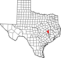 | |
| Towns | ||
| CDP | ||
| Unincorporated communities | ||
| Ghost towns | ||
