Montague, Texas
| Montague, Texas | |
|---|---|
| Census-designated place (CDP) & Unincorporated Community | |
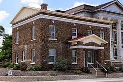 Old Montague County Jail in Montague | |
 Montague, Texas  Montague, Texas | |
| Coordinates: 33°39′53″N 97°43′14″W / 33.66472°N 97.72056°WCoordinates: 33°39′53″N 97°43′14″W / 33.66472°N 97.72056°W | |
| Country | United States |
| State | Texas |
| County | Montague |
| Area[1] | |
| • Total | 1.276 sq mi (3.30 km2) |
| • Land | 1.276 sq mi (3.30 km2) |
| • Water | 0 sq mi (0 km2) |
| Elevation | 1,073 ft (327 m) |
| Population (2010)[1] | |
| • Total | 304 |
| • Density | 240/sq mi (92/km2) |
| Time zone | UTC-6 (Central (CST)) |
| • Summer (DST) | UTC-5 (CDT) |
| Area code(s) | 940 |
| GNIS feature ID | 1363054[2] |
Montague (/ˈmɒnteɪɡ/ MAHN-tayg[3][4]) is a census-designated place and unincorporated community in Montague County, Texas, United States. It is the county seat of Montague County[5] and had an estimated population of 400 in 2000, according to the Handbook of Texas.[6] Its population was 304 as of the 2010 census.[1]
Geography
Montague is located at 33°39′53″N 97°43′14″W / 33.66472°N 97.72056°W (33.6648266, -97.7205857), near the intersection of State Highways 59 and 175 in central Montague County.
The community is situated approximately 80 miles (130 km) northwest of Fort Worth, 60 miles (97 km) southeast of Wichita Falls, and 11 miles (18 km) northeast of Bowie.[7]
History
Montague was established in 1858 on 160 acres (0.65 km2) of land donated by the state of Texas.[6] The community was named for Daniel Montague, an early surveyor. A post office opened in 1860. There were an estimated 400 residents living in the community by 1880 as well as five businesses, three churches, a school, and the only flour and grist mills in the county. Montague was incorporated in 1886. An attempt that same year by W.A. Morris and C.C. White to save the community from isolation by constructing an independent rail line that would have connected Montague with Bowie proved unsuccessful due to a lack of funds.[7] Residents of the town voted to dis-incorporate the community in 1900.[6]
In 1915, there were an estimated 300 people living in Montague. That figure reached a low of 284 in 1947. As highway traffic replaced the railroads, a modest recovery began and the community began growing again by the 1970s.[6] In 1990 and 2000, there were around 400 residents living in the community.[7]
Education
Public education in Montague is provided by the Montague Independent School District, which serves students in grades pre-kindergarten through eight. Ninth through twelfth graders attend high school in nearby Nocona.
Climate
The climate in this area is characterized by hot, humid summers and generally mild to cool winters. According to the Köppen Climate Classification system, Montague has a humid subtropical climate, abbreviated "Cfa" on climate maps.[8]
See also
References
- 1 2 3 "2010 Census Gazetteer Files - Places: Texas". U.S. Census Bureau. Retrieved March 18, 2017.
- ↑ "Montague". Geographic Names Information System. United States Geological Survey.
- ↑ "How to Pronounce: M Cities". 23 September 2014. Retrieved 20 May 2018.
- ↑ "Texas Almanac Town Pronunciation Guide" (PDF).
- ↑ "Find a County". National Association of Counties. Retrieved 2011-06-07.
- 1 2 3 4 "Montague, Texas". The Handbook of Texas online. Retrieved 2009-03-29.
- 1 2 3 "Montague, Texas". Texas Escapes Magazine. Retrieved 2009-03-29.
- ↑ "Montague, Texas Köppen Climate Classification (Weatherbase)". Weatherbase. Retrieved 19 April 2018.
External links
- Montague from the Handbook of Texas Online
- Montague ISD – Official site.
- Montague County, Texas – Official site.
Municipalities and communities of Montague County, Texas, United States | ||
|---|---|---|
| Cities | 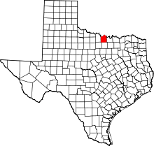 | |
| CDPs | ||
| Other unincorporated communities | ||
| Ghost town | ||