Boston Post Road Historic District (Rye, New York)
|
Boston Post Road Historic District | |
 The National Park Service designated the Boston Post Road Historic District in 1993 | |
  | |
| Location | Rye, New York |
|---|---|
| Built | 1838-1854 |
| Architect | Multiple |
| Architectural style | Gothic Revival, Greek Revival |
| NRHP reference # | 82001275 |
| Significant dates | |
| Added to NRHP | October 29, 1982[1] |
| Designated NHLD | August 30, 1993[2] |

The Boston Post Road Historic District is a 286 acre National Historic Landmark District that is composed of 5 distinct and adjacent properties.[3] Within this landmarked area are three architecturally significant, pre-Civil War mansions and their grounds,[4] a 10,000-year-old Paleo-Indian site and viewshed, a private cemetery, and a nature preserve. It is 1 of only 11 National Historic Landmark Districts in New York State and the only National Historic Landmark District in Westchester County. It touches on the south side of the nation's oldest road, the Boston Post Road (US 1) in Rye, New York. A sandstone Westchester Turnpike marker "24", inspired by Benjamin Franklin's original mile marker system, is set into a wall that denotes the perimeter of 3 of the contributing properties. The district stretches down to Milton Harbor of Long Island Sound. Two of the properties included in the National Park designation are anchored by Greek Revival buildings; the third property is dominated by a Gothic Revival structure that was designed by Alexander Jackson Davis.
This site, which also has immense archaeological significance and importance to American and Native American heritage, [5] was declared a National Historic Landmark in 1993.[2][6] The three-quarters-mile (1.2 km) meadow and viewshed is one of fewer than a dozen such identified Paleo-Indian sites in all of New York State.[7] In 2005, J. Winthrop Aldrich, former assistant to six successive Commissioners of New York State Department of Environmental Conservation (1974-94) and Deputy Commissioner New York State Office of Parks, Recreation and Historic Preservation (1994-2003; 2007-10) attested that the District was acknowledged to be "one of New York State's finest assets" "amply deserving the rare honor of National Historic Landmark designation by the Secretary of the Interior." [8]
Components of the District
Included within the district are the following historic buildings, structures and landscape features:


Jay Estate (1745 and earlier)
The historic 23 acre Jay Estate, including its buildings, landscape and gardens, is being restored by the not-for-profit Jay Heritage Center. The site was added to the Westchester County African American Heritage Trail in 2004 by then County Executive Andrew Spano because of its association with John Jay and his role in abolishing slavery in New York. It was designated a member site of the Hudson River Valley National Heritage Area in January 2009 because of 1) the architectural and historical significance of its buildings; 2) as significant parkland it illustrates the role of the Hudson River Valley in the modern environmental movement; 3) the site is associated with great Americans and social issues, particularly the examination of the abolition of slavery; and 4) because of its once notable formal gardens and landscape. [9] Governor Andrew Cuomo added the site to New York State's Path Through History in 2013 for its ongoing relevance to the historic interpretation of Civil Rights in New York.
The 1838 Peter Augustus Jay Mansion at the center of the property is owned outright by the Jay Heritage Center and is one of two Greek Revival residences in the larger landmarked district. The mansion is situated on the site of the childhood home of American Founding Father John Jay with approximately the same orientation and viewsheds. The existing house was built upon the footprint of an older 18th-century farmhouse, "The Locusts", and replaced with the current structure by John Jay's eldest son, Peter Augustus Jay. The mansion was erected according to specifications in a contract between Jay and a builder named Edwin Bishop, and details appear to have been drawn from architectural pattern books by Minard Lafever and Chester Hills.[6]:13 Restoration of the house is an official Save America's Treasures project. The
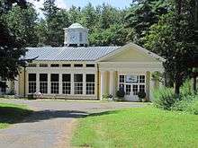
- 1907 Van Norden Carriage House (designed by Frank A. Rooke)
This bright yellow Classical Revival structure serves as the Visitor Center and is open to the public.
- 1907 Zebra House (designed by Frank A. Rooke)
- Tennis House (1917 or earlier)
- Cottage on Barlow Lane (18th century or earlier)
- Summer House (1957-8, non-contributing)
- Estate Cottage B (demolished)
- Bowling Alley (demolished)
- Four outbuildings (demolished)
- Gazebo (demolished)
- Gardens designed by Jay family, Brinley & Holbrook and others; includes dry-laid stone ha-ha walls (1822). Currently being restored and rehabilitated by Nelson Byrd Woltz Landscape Architects.
Jay Family Cemetery (1806)
The Jay Cemetery is a private cemetery of three acres [1.2 ha]. John Jay was laid to rest there in 1829. It is not open to the public for visitation.
Lounsbury (1831) also known as Lounsberry or the Parsons Estate
A second Greek Revival residence in the district notably has a library designed by Delano & Aldrich. It is privately owned and not open to the public.
- Gardener's Cottage
- Carriage House and Stable
- Outbuilding with five bays
- Poultry and Wood House
- Greenhouse
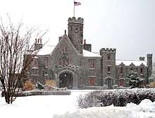
Whitby Castle (1854) Gothic Revival
Former Chapman family residence, which is now the City of Rye Golf Club. Designed by Alexander Jackson Davis
- Caretaker's house
- Pool house and golf cart garage (non-contributing)
- Starter's House (non-contributing)
- Maintenance building (non-contributing)
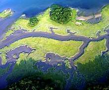
Marshlands Conservancy (formerly Devereux Reservation, 1966)
The Marshlands Conservancy is owned and operated by Westchester County Parks. It is a nature preserve with a diverse number of habitats - several ponds, an East Stream, West Creek, open meadow, woodland, salt marsh, and fresh water wetlands - that attract a variety of flora and fauna. Historically, the land was part of the larger old Jay Estate and the neighboring Parsons Estate. It was formed out of two separate gifts in the 20th century: one of 120 acres given by Zilph Devereux to Westchester County on November 9, 1966 and another of 27 acres given by Fanny Wickes Parsons to Westchester County in December 1977. The resulting parcel of 147 acres [59 ha] was rededicated as passive parkland in 1997 by Westchester County so that "The natural area and wildlife sanctuary will be protected, preserved and regulated as a nature and wildlife preserve to be used only for passive recreation." [10] It has been recognized as an Important Bird Area.
See also
References
- ↑ National Park Service (2007-01-23). "National Register Information System". National Register of Historic Places. National Park Service.
- 1 2 "Boston Post Road Historic District". National Historic Landmark summary listing. National Park Service. 2007-09-14. Archived from the original on 2007-12-14.
- ↑ Clary, Suzanne (November 2017). "What Becomes a Landmark Most". Rye Magazine. No. 61. Weston Magazine Publishers. Retrieved February 19, 2018.
- ↑ Stephanie Strasnick. "5 New York Getaways for Architectural History Buffs". Architectural Digest. Retrieved March 18, 2018.
- ↑ Jay Heritage Center. "Archaeology". Retrieved March 18, 2018.
- 1 2 Karen Kennedy and Austin O'Brien (December 12, 1986), National Register of Historic Places Inventory-Nomination: Boston Post Road Historic District (pdf), National Park Service and Accompanying 33 photos, exteriors and interiors, from 1979-1983. (7.94 MB)
- ↑ Pfeiffer, John (April 21, 1982). Preliminary Archaeological Survey of the Boston Post Road Historic District of Rye, NY. p. 2.
- ↑ "Rye City Commission Planning Minutes, March 8, 2005" (PDF). Retrieved March 18, 2018.
- ↑ Greenway Heritage Conservancy HRV, Inc.. Hudson River Valley Heritage Area: Heritage Site Guidebook, 2010, p 14.
- ↑ Westchester County (February 13, 1997). Act No. 46 - 1997, An Act To Set Aside the Marshlands Conservancy as a Natural Park and as a Wildlife Sanctuary to be Set Aside for the Use and Development of Habitat Management and Wildlife Protection. p. 311-313.
External links
| Wikimedia Commons has media related to Boston Post Road Historic District (Rye, New York). |
- Historic American Buildings Survey (HABS) No. NY-4115, "Parsons-Lounsbury House, Boston Post Road, Rye, Westchester County, NY", 5 photos, 15 measured drawings, 4 data pages, supplemental material
- Jay Heritage Center - Official Site
- Jay Family Cemetery
- Hudson River Valley National Heritage Area
- African American Heritage Trail of Westchester County
- Library of Congress - Local Legacies - Jay Heritage Center
Coordinates: 40°57′31″N 73°42′07″W / 40.958487°N 73.701922°W
| Topics |   | |
|---|---|---|
| Lists by county |
| |
| Lists by city | ||
| Other lists | ||
| ||