Bodoland
| Bodoland | |
|---|---|
 | |
| Capital and largest city |
Kokrajhar 26°24′N 90°16′E / 26.4°N 90.27°E |
| Official languages | Bodo |
| Ethnic groups |
|
| Government | Autonomous Territorial Council in India |
• Chief, BTC | Hagrama Mohilary |
• Deputy Chief, BTC | Kampa Borgoyary |
| Legislature | Bodoland Territorial Council (legislative powers in 40 subjects) and Assam Legislative Assembly |
| Establishment | |
• BTC Accord | 10 February 2003 |
| Area | |
• Total | 8,821.68 km2 (3,406.07 sq mi) |
• Proposed area | 25,478 km square |
| Population | |
• Census | 3,155,359 |
• Density | 374/km2 (968.7/sq mi) |
| Currency | Indian rupee |
| Time zone | UTC+5:30 (IST) |
| Date format | dd-mm-yyyy |
| Driving side | left |
| Calling code | +91 |
|
Website http://www.bodoland.gov.in | |
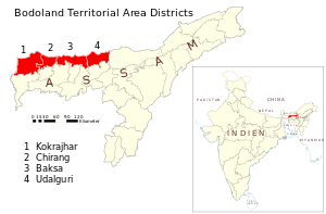
Bodoland, officially the Bodoland Territorial Area Districts (BTAD), is an autonomous territory consisting of areas located in the extreme north on the north bank of the Brahmaputra river, within the state of Assam and north east region of India, by the foothills of Bhutan and Arunachal Pradesh. The region is predominantly inhabited by the indigenous Bodo people. The official map of Bodoland includes four districts of BTAD recognised by the Government of India. It is administered by the Bodoland Territorial Council, which covers over eight thousand square kilometres. The territory came into existence under the BTC Accord in February 2003.[2]
Etymology
It is said that the original home of Bodos was in the north of China in between the head-waters of the Huang Ho and the Yang-tzse Kiang rivers from which they moved out and dispersed in different directions. One of the groups moved into Tibet and settled there for centuries. Thus Tibet became their home before coming to India. As is known, the original name of Tibet was Ti-bod. It is conjectured by some of the scholars that the Mongoloids who lived in Ti-bod were identified as bod who later changed to Bodo.
Before the impact of Sanskritisation they were known as Kachari by the Hindus in Assam and as Meches in Bengal. The controversial spelling of the word is ‘Bodo’ where the letter ‘d’ is pronounced not as ‘d’ but as hard’ r.’ It was Brian Hodgson who first applied the generic name Bodo to this group of languages but their own name for their race is Boro. This generic name is also applied to the tribes and sub-tribes belonging to the Bodo group. The Bodo intellectual leaders of the national convention who took the decision to accept the generic name’ Bodo’ as the racial name were aware of it as it was already in use. At present it is found that the use of the names Bodo and Boro are going on in parallel. The decision of the 1952 national convention is thus honored.[3]
History
Historically it was inhibited by the Boros or Bodos or the Kacharis before the intrusion of the Aryans. The British gained control of the region through the Treaty of Yandabo upon winning the First Anglo-Burmese War in 1826. The war was primarily for the control of Northeast India between the British and Burmese empires. It was than known as the Kachari Dwars or Kachari plains or Kachari country by the British during the British Raj. The Bodo people in the Brahmaputra Valley have survived in the midst of Aryan and Shan invaders and settlers, while one of its cousins known as Koch, that ruled the Koch Kingdom have now gradually become a semi-Hindu caste, due to their inter-marriage with the Dravidians and gave birth to a mixed Mongoloid-Dravidian race,[4] who now talks the Indian Bengali or Assamese. Surviving remnants of the royal family of Koch empire proved aboriginal members of the Koch caste spoke Bodo language.
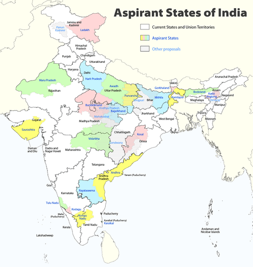
Demand for a homeland
Along with the other parts of Northeast India, regional aspiration in the region reached a turning point in the 1980s. The isolation of the region, its complex social character and its backwardness compared to other parts of the country have all resulted in the complicated set of demands ranging from demand for autonomy and opposition to 'outsiders' to movements for secession.
The region is also the gateway to the North Eastern Region of India, where one of the main students organization, All Bodo Students Union (ABSU), allied with National Democratic Front of Boroland - Progressive (NDFB-P), National Democratic Front of Boroland - D.R. Nabla faction, People's Joint Action Committee for Boroland Movement (PJACBM) which is an amalgamation of over three dozen Bodo organisations[5] and it's supporters are demanding from the Government of India that a separate state (within the Indian Union) be created comprising the seven districts of Kokrajhar, Chirang, Baksa, Udalguri, Sonitpur, Lakhimpur and Dhemaji of Assam which have a significant Bodo population.[6][7] On the other hand, it is also claimed as a sovereign state (Complete independence) by the separatist insurgent group NDFB.[8]
The Bodoland movement is similar to the story of Mizoram and the Mizo National Front except that the later was granted full-fledged statehood with special powers and MNF agreeing to give up secessionist struggle, the former has not yet had such a happy ending and the region continues to be extremely sensitive.[9]
It is currently an autonomous Administrative unit constituted under the Sixth Schedule of the Constitution of India covering an area of 8,795 km2 (Provisional).
The administrative unit has been created with a mission to accomplish development in the area of economic, education, preservation of land right, linguistic aspiration, socio-culture and ethnic identity of Bodos and above all to speed up the infrastructure development of communities in the BTC area. The actual functioning of council was started on 7 December 2003 by constituting the 12 members of the Council provisionally. After the Council Election on 13 May 2005 and subsequent bye-election in November 2005, the 40-member Legislative Council has been formed to look after the development works in the Bodoland Territorial Area Districts. The remaining six members are nominated by the Governor of Assam from the unrepresented Communities. Thus there are altogether 46 members of the Council, representing all communities of BTC Area known as Member of Council Legislative Assembly (MCLA).
Politics
The BTC Accord
The Bodoland Territorial Council (BTC) is a territorial council that was established in Assam state of India according to the Memorandum of Settlement of 10 February 2003. BTC came into existence immediately after surrender of Bodo Liberation Tigers Force (BLTF) cadres. The BLTF laid down their weapons on 6 December 2003 under the leadership of Hagrama Mohilary and Hagrama was sworn in as the Chief Executive Member (CEM) on 7 December 2003. The BTC has 46 executive members each looking after a specific area of control. The area under the BTC jurisdiction is called the Bodoland Territorial Area District (BTAD). BTC constitutes 35% of marginalised Tribal groups like Bodos, Rabhas, Garos etc. who are against the hegemony of Assam government.
Government
Executive Council
| Minister | Ministry | |
|---|---|---|
| 1 | Hagrama Mohilary | Chief of the Council, PWD, P & RD, WPT & BC, IBA |
| 2 | Kampa Borogoyary | Deputy Chief of the Council, Forest, Tourism, Education |
| 3 | Lwmsraw Daimary | PHE, Museum & Archaeology, Excise |
| 4 | Bonjar Daimary | Food Civil Supplies & Consumer Affairs, Cinema, Cultural Affairs |
| 5 | Rajib Brahma | Irrigation, WPT & BC (Plan Fund) |
| 6 | Mritunjay Narzary | Social Welfare, Information & Public Relations |
| 7 | Alindra Mushahary | Land Revenue & Disaster Management, Printing & Stationery, Market & Fairs |
| 8 | Ganesh Kochary | Health Services, Cottage Industry |
| 9 | Doneswar Goyary | Urban Development and Town & Country Planning, Sports & Youth Welfare |
| 10 | Ansumwi Khungur Boro | Agriculture, Weight & Measure |
| 11 | Deben Boro | Handloom & Textile, Sericulture |
| 12 | Shyam Sundi | Fishery, Animal Husbandry & Veterinary, Labour & Employment |
| 13 | Jagadish Sarkar | Soil Conservation, Transport, Cooperation |
| 14 | Maheswar Basumatary | Water Resources, Library Services |
Administrative Divisions
The BTAD has been divided into four districts for administrative purpose. It has been further subdivided into 10 Civil Subdivisions and 40 Development Blocks. The area and population under the four districts has been estimated as follows:
| Sl No | Name of the District |
Area in km2. | Population (census 2011) |
|---|---|---|---|
| 1 | Kokrajhar | 3,169.20 | 887,142 |
| 2 | Chirang | 1,069.96 | 482,162 |
| 3 | Baksa | 3,056.89 | 950,075 |
| 4 | Udalguri | 1,673.93 | 831,668 |
| Total | 8,969.98 | 3,151,047 |
Geography
The geographical boundary of BTAD lies between 260 7'12'' N to 260 47' 50'' N Latitude and 890 47' 40'' E to 920 18' 30'' E Longitude and is in the North Western part of Assam. Kokrajhar town the Administrative Head Quarter lies roughly between 260 25' N Longitude and 990 16' 38'' E Latitude.
Its strategic location is blessed with beautiful forests of flora and founa.[1]
Economy
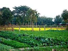
The economy is largely agricultural based and is lagging behind in urbanization and development. The region is industrially backward with most of its population depending on agriculture for livelihood. Most of the industries like oil, gas and major industries of the state are located in upper Assam.
Urbanization
The region is one of the most underdeveloped and backward regions of India of which only 3 percent of the population live in urban areas.
Tourism
Tourism in the region is regulated by the department of Bodoland Tourism. Manas National Park is the major tourist attraction of the region. It also have many wildlife sanctuaries, reserve forests, site seeings, picnic spots and events.[10]
Manas National Park
Manas, the nature's abode is at the foothills of Bhutan with its unique biodiversity and landscape. The blending of the dense jungle and grassland at the confluence of Indian, Ethiopian and Indo Chinese realms enhances it as one of the richest region of wild animals. The Park harbours 60 species of mammals of which 23 has been listed in the Schedule 1 under the Indian Wildlife Protection Act 1972. The Park also has a recorded count of 36 species of reptiles and 476 species of birds. The Park is home for Elephant, Rhino, Tiger, Gaur, Wild Buffalo, Deer, wild Hogs, and many other Reptiles, Birds and Insects including some highly endangered species like Pigmy Hog, Golden Langur & Bengal Florican. It is not only a significant National Park of India, but also an important migratory corridor for the elephant population of the entire Indo-Bhutan region. Manas is also included in the much ambitious plan nomenclatured as Indian Rhino Vision -2020 (IRV-2020) since 2006, with support of Govt. of Assam in collaboration with Wildlife Trust of India. (WTI), Bodoland Territorial Council, WWF-India, International Rhino Foundation and US Fish and Wildlife Service.
Diplai Beel
It is about 30 mins. drive from Kokrajhar town. The Beel is home to a large number of migratory and resident birds and different species of amphibians; like fish, dolphin etc. You can also enjoy Boat-rides in this beel.
Bogamati
Bogamati located at the foothills between the hills ranges of Indo- Bhutan border is a hot tourist spot for picnickers and is a paradise for nature lover. The spot is a beautiful picturesque surrounded by greenery and hills along with the Bornadia river flowing downhill. Talks are on to develop water sports in this area.
Trekking of Baukungri Hill
Baukungri hill trekking is an exiting and adventerous event that is organised every year on first day of the year according to Bodo Calendar which falls in mid April. People from neighbouring states along with the host state arrives every year for a week. International tourists from neighbouring Countries and Westerns Countries are also among those who waits for this exiting event. Cultural and traditional fusion of various ethnic groups can be seen during this event. Tourists can have taste of this rich cultural event with wide range of mouth watering cuisines of the native people.
Infrastructure
Transportation
Bodoland is served by the transportation department of the Bodoland Territorial Council.[11]
Energy
Electricity
State Power Sector Reform Programme under the provision of electricity act 2003 resulted in the unbundling of Assam State Electricity Board into three new succeeding companies namely Assam Power Generation Co. Ltd., Assam Electricity Grid Corporation Ltd. and Assam Power Distribution Company Ltd.
The Assam Power Generation Corporation Limited is mainly responsible for maximum energy generation to meet up the energy demand in the state of Assam,[12] while the latter is responsible to efficiently transport electrical power from electrical power bulk heads to the distribution company networks in the state of Assam.[13]
The primary purpose of the Assam Power Distribution Company Limited is to undertake distribution, trading and supply of electricity in the state of Assam or outside of it.[14]
Demographics
Population
Bodos are the majority community in the region followed by Bengali Muslims, who form the largest minority group.[15] The population of BTC area as per 2001 Census report is 2,920,000 out which the ST population is around 52% or approximately 1,500,000 of which only 3% of the total population live in urban area. The average density of the population in BTC is 326 Sq.K.m. compared to 340 per Sq.K.m. of Assam. Amongst the Tribal population Bodos, Rabhas and less quantity of Garos are inhabiting in this area out which Bodos will be 90% or approximately 1,400,000.[15] The other communities like Ransbanhis, Sarania are inhabiting in large part of BTC. Besides Tea and Other Ex-Tea tribes including Santhal, Orao etc. are also available. Moreover, other general communities like Bengali, Assamese, Nepali and few numbers of Hindi speaking people are also found in the Council area.[16]
Education
Literacy rate
Bodos have a literacy rate (7 years and above) of 61.3% while the Rabhas have 66.7%.[17]
Culture
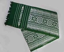
The Bodos have a distinct culture from the rest of the world, ranging from dance and music to festivals and attires. It also contributed significantly to the development of the Assamese culture.
Sports
Football is the most popular sport in the region. The region has many Football clubs of which Baarhoongkha AC, Udalguri FC and Global FC is the most widely known as they participate in Assam State Premier League, the premier football league of the state. Bodoland Martyrs Gold Cup is organised every year in memory of Bodoland martyrs, who sacrificed their lives for the cause of Bodoland movement.[18] The region has also produced many national level athletes. Other sports followed in the region are Badminton, Basketball, Volleyball, Cricket, Taekwondo, Kabaddi, Chess, Archery, and other indigenous sports.[19]
See also
References
- 1 2 3 "About Bodoland". www.bodoland.in. 2 December 2018.
- ↑ BTC Accord
- ↑ Goswami, Madhurima. "The BODOS: Culture and Society".
- ↑ http://www.ticijournals.org/locating-kamatapur-movement-origin-change-and-continuity/
- ↑ http://m.hindustantimes.com/india-news/bodo-groups-impose-12-hour-bandh-in-assam-over-statehood-demand/story-nGRNnkfVZaCV0IAqKBmPiI.html
- ↑ https://www.telegraphindia.com/states/north-east/a-demand-for-bodoland-with-blood-183987
- ↑ http://www.sentinelassam.com/story/news/2/bodoland-movement-group-announces-series-of-agitation-prgrammes/2017-10-23/1/317768#.Wk3zRaDhXqA
- ↑ https://www.time8.in/ndfbs-eyes-bodoland-sovereignty/
- ↑ http://mizoram.nic.in/about/history.htm
- ↑ "Bodoland Tourism". www.bodolandtourism.org. Retrieved 2017-03-26.
- ↑ https://www.highbeam.com/doc/1P3-1566924891.html
- ↑ http://www.apgcl.org/comp_prf.html
- ↑ http://www.aegcl.co.in/comprofile.html
- ↑ http://www.apdcl.gov.in/irj/go/km/docs/internet/ASSAM/webpage/pages/Company_profile.html
- 1 2 https://m.economictimes.com/assam-violence-chief-reasons-behind-the-rivalry/bodos-say-most-muslim-settlers-are-illegal-migrants/amp_slideshow/15570061.cms
- ↑ "Bodoland Territorial Council | Kokrajhar". bodoland.gov.in. Retrieved 2017-03-28.
- ↑ "2011 Estimates as per Census report 2001" (PDF).
- ↑ https://www.assamtimes.org/node/20275
- ↑ "Assam State Premier League".
External links
| Proposed states |
|  |
|---|---|---|
| Proposed territories |
| |
Coordinates: 26°24′00″N 90°16′12″E / 26.40000°N 90.27000°E