Binghamton metropolitan area
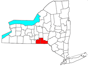
The Binghamton Metropolitan Statistical Area, also called Greater Binghamton or the Triple Cities, is a region of southern upstate New York in the Northeastern United States, anchored by the city of Binghamton. The MSA encompasses Broome and Tioga counties,[1] which together had a population of 251,725 as of the 2010 census.[2] From 1963 to 1983, the MSA also included neighboring Susquehanna County in Pennsylvania,[3] part of which still falls in the Binghamton, NY–PA Urban Area.[4] In addition to these three counties, the greater region includes parts of Delaware and Chenango counties in New York; portions of Cortland and Otsego counties in New York and Wayne County, Pennsylvania are sometimes considered part of the region as well. Using the definition of a 30-mile radius from Binghamton, the population as of the 2010 census is 317,331.[5]
The Greater Binghamton name was adopted in the early 21st century to better identify the region with its most well-known city in efforts of marketing and external promotion.
The metropolitan area is located in the Southern Tier of New York State and lies on Pennsylvania's northern border, approximately 66 miles (110 km) south of Syracuse, New York.
Triple Cities
Historically, the region has been known as the Triple Cities and is made up of Binghamton, Johnson City, and Endicott, New York, the latter two of which are technically villages.[6]
The area is also sometimes called the "Greater Binghamton Area" as the city of Binghamton is the largest and most prominent of the three, with a population greater than the other two combined, and a much larger geographical area. The three incorporated areas are tightly squeezed together and can seem like a single large, albeit spread out, city. They are economically integrated, though they retain their political identities. For example, many people living in Binghamton go shopping at the Oakdale Mall in Johnson City on a regular basis, and it's very common for someone living in one city to work or go to school in one of the other two.
Some have put forward the idea of merging the three into a single city, but it seems politically unlikely. While "triple cities" strictly covers only the three main municipalities mentioned, the term is also used by some to refer broadly to the surrounding area of conurbation, including Endwell, West Corners, the Upper Front Street area (technically in the town of Dickinson), and the town of Vestal. Vestal is home to the Vestal Parkway, a major commercial strip for the entire area, housing one of the two major multiplex theaters in the area, and a number of shopping plazas, major chain stores, and eateries. Binghamton University is also physically located in Vestal, though its mailing address is in Binghamton.
Transportation
The Municipalities all sit together, parallel to the Southern Tier Expressway (NY 17, the main part of future Interstate 86). This along with a junction to Interstate 81, Interstate 88, and U.S. Route 11 along with New York State Route 12, form the main transportation routes for the area. NY 17, and I-81 are the high-speed roadways providing quick expressway access between the cities, while the other two serve as secondary gateways to the area. Interstate 88 starts between exits 5 and 6 on I-81 and terminates in Albany.
Broome County Transit operates 14 fixed route bus lines in and around Binghamton and its metropolitan area. Greyhound Bus Lines and New York Trailways operate intercity coach bus service through Binghamton with direct connection to major cities in the region such as Ithaca, Syracuse, Rochester, Albany, and New York City
In addition, Greater Binghamton Airport is located in Maine, New York. As of 2018, Delta is the only commercial carrier with scheduled service.
Main Street begins at downtown Binghamton and runs through Johnson City, Endwell, and Endicott.
Communities
Cities
- Binghamton (Principal city)
Towns
Villages
Census-designated places
Hamlets
- Hillcrest
- Chenango Forks
- Chenango Valley
- Killawog
- Nineveh
Demographics
As of the census[2] of 2010, there were 251,725 people, 102,517 households, and 62,796 families residing within the MSA. The racial makeup of the MSA was 89.8% White, 4.0% African American, 0.2% Native American, 3.0% Asian, 0.04% Pacific Islander, 0.8% from other races, and 2.2% from two or more races. Hispanic or Latino of any race were 3.0% of the population.
As of the 2000 Census, the median income for a household in the MSA was $37,807, and the median income for a family was $45,966. Males had a median income of $33,294 versus $24,098 for females. The per capita income for the MSA was $18,921.[7]
Colleges and universities
- Broome County
- Binghamton University in Vestal
- SUNY Broome in Dickinson
- Davis College in Johnson City
- Elmira Business Institute in Vestal
- In Binghamton:
- Empire State College learning center
- Ridley-Lowell Business and Technical Institute's Binghamton campus
- State University of New York Upstate Medical University clinical campus
- Tioga County
See also
References
- ↑ METROPOLITAN STATISTICAL AREAS AND COMPONENTS Archived May 26, 2007, at the Wayback Machine., Office of Management and Budget, 2007-05-11. Accessed 2008-07-27.
- 1 2 "American FactFinder". United States Census Bureau. Archived from the original on 2013-09-11. Retrieved 2011-05-14.
- ↑ "Metropolitan and Micropolitan - Historical Statistical Area Delineations". United States Census Bureau. Retrieved 10 March 2016.
- ↑ "2010 Urban Area Boundaries". New York State Department of Transportation. Retrieved 10 March 2016.
- ↑ "2010 Demographics Report".
- ↑ "Invaders Repelled". Time Magazine. January 20, 1961.
- ↑ "American FactFinder". United States Census Bureau. Archived from the original on 2013-09-11. Retrieved 2008-01-31.