Highways in Hungary
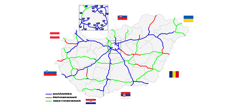
According to the Állami Autópályakezelő Zrt. ("State Motorway Management Plc."), the total length of the Hungarian motorway system was 1,491 kilometers in 2018.[1] The construction of the Hungarian motorway system started in 1964 with M7, which finished in 1975 between Budapest and the Lake Balaton. The total length of the system reached 200 km in 1980, 500 km in 1998 and 1000 km in 2007.
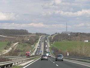
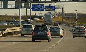
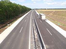
The motorways in Hungary, Hungarian: autópálya (abbr. M), are defined as two-lane motorways in each direction, with an emergency lane. The speed limit is 130 km/h or 80 mph.
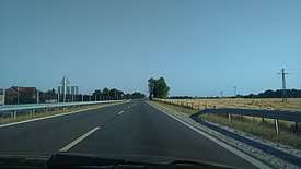
The expressways in Hungary, Hungarian: autóút, are defined as two-lane motorways in each direction. The speed limit is 110 km/h or 70 mph. Their highway shields are white on blue and road signs are white on blue, as well.
The Hungarian motorway network currently comprises 13 motorways, 13 expressways, and some fast roads (R), of which 21 of them are at least partially operational, and 9 (M1, M5, M7, M15, M19, M31, M43, M51 and M70) have been completed by the end of 2016.
Highways system


Motorways
The motorways in Hungary, Hungarian: autópálya (abbr. M), are defined as two-lane motorways in each direction, with emergency lane. The speed limit is 130 km/h or 80 mph. Their road signs are white on blue.
| Number | E-road | Route | Length |
|---|---|---|---|
| Budapest - Tatabánya - Győr - Mosonmagyaróvár - Hegyeshalom → (AUT border) |
171 km | ||
| Budapest - Hatvan - Füzesabony - Polgár - Nyíregyháza - Vásárosnamény - Beregdaróc → (UKR border) | 307 km Existing: 280 km | ||
| Budapest - Szolnok - Püspökladány - Nagykereki → (ROU border) |
233 km Existing: 29 km | ||
| Budapest - Kecskemét - Szeged - Röszke → (SRB border) |
173 km | ||
| Budapest (M0) - Dunaújváros - Szekszárd - Mohács - Ivándárda → (CRO border) |
212 km Existing: 193 km | ||
| Budapest - Székesfehérvár - Siófok - Nagykanizsa - Letenye → (CRO border) |
233 km | ||
| Szolnok (M4) - Kecskemét - Dunaújváros - Veszprém - Rábafüzes → (AUT border) |
330 km Existing: 35 km | ||
| 15 km | |||
| 10 km | |||
| (Via Carpatia) |
95 km Existing: 28 km | ||
| Transit road from |
12 km | ||
| 69 km Existing: 53 km | |||
| Szeged (M5) - Makó - Csanádpalota → (ROU border) |
58 km | ||
| 56 km Existing: 32 km |
Expressways
The expressways in Hungary, Hungarian: autóút (abbr. M as well) are defined as dual carriageways with lower standards than that of a motorway, but with the same restrictions. The speed limit is 110 km/h or 70 mph. Their road signs are white on blue.
| Number | E-road | Route | Length |
|---|---|---|---|
| Budapest Ring | 108 km Existing: 77 km | ||
| Budapest (M0) - Vác - Parassapuszta → (SVK border) |
70 km Existing: 32 km | ||
| Szombathely (M86) - Zalaegerszeg - Nagykanizsa - Kaposvár - Szekszárd - Szeged (M5) | ~ 300 km Existing: 21 km | ||
| Budapest - Pilisvörösvár - |
34 km Existing: 0 km | ||
| 19 km Existing: 0 km | |||
| 39 km Existing: 0 km | |||
| Kecskemét (M8) - Békéscsaba - Gyula → (ROU border) | 111 km Existing: 0 km | ||
| Part of old ring of Budapest | 9 km | ||
| 21 km | |||
| Győr (M1) - Csorna - Sopron → (AUT border) |
~ 80 km Existing: 31 km | ||
| Szombathely - Csorna - |
115 km Existing: 71 km | ||
| Szombathely (M86) - Kőszeg → (AUT border) |
20 km Existing: 0 km |
Fast roads
The fast roads in Hungary, Hungarian: gyorsút (abbr. R) are defined as dual carriageways with lower standards than that of a expressway, but the level intersection (eg, traffic light node, roundabout) is permissible. The speed limit is also 110 km/h or 70 mph.
| Number | Route | Length |
|---|---|---|
| ? km Existing: 0 km | ||
| 45 km Existing: 0 km | ||
| 46 km Existing: 0 km | ||
| Győr (M1) - Pápa | 36 km Existing: 0 km |
- 2x2 traffic lanes main roads
- Road
_Otszogletu_zold_tabla.svg.png)
- Several parts of Road
_Otszogletu_zold_tabla.svg.png)
- Road
_Otszogletu_zold_tabla.svg.png)
- Road
_Otszogletu_zold_tabla.svg.png)
- Several parts of Road
_Otszogletu_zold_tabla.svg.png)
- In the future this sections will be part of M8.
- Road
_Otszogletu_zold_tabla.svg.png)
- Several parts of Road
_Otszogletu_zold_tabla.svg.png)
- In the future this sections will be part of R21.
- Road
_Otszogletu_zold_tabla.svg.png)
- Road
_Otszogletu_zold_tabla.svg.png)
- Road
_Otszogletu_zold_tabla.svg.png)
- Road
_Otszogletu_zold_tabla.svg.png)
- Road
_Otszogletu_zold_tabla.svg.png)
Toll requirements

The e-vignette user charge system applies to motorcycles, passenger cars and their trailers, as well as cargo vehicles with a maximum permissible gross weight of 3.5 tonnes, campers and buses, and their trailers. These vehicles are authorized to use the Hungarian toll speedway network’s roads exclusively with pre-purchased –purchased prior to entering a toll speedway section– road use authorization, i.e. e-vignettes. The amount of toll charges depends on the category of the vehicle and the type of thee-vignette. The category of the motorvehicles must be determined according to the official entry that appears in the vehicle registration certificate, based on the maximum permissible grossweight of the motor vehicle and the number of persons it is allowed to transport.[2]
Hungarian system has 2 main type in terms of salary.
1, time-based fee vignettes (E-matrica) with a validity of either 10 days (2975 HUF), 1 month (4780 HUF) or 1 year (42980 HUF). The following motorway sections are toll-free for cars up to 3.5 t:[3]
- the following sections of the M0 expressway: - 63 km
- the section between Main Road 1 (exit -1) and the M5 motorway (exit 32),
- the section between M4 expressway (exit 41) and M3 motorway (exit 68),
- Megyeri Bridge (the section between Main Road 11 and Main Road 2), (exit 74-77).
- the M31 motorway - 12 km
- the section of M4 expressway (sign of Main Road 4) between the road leading from Vecsés to Budapest Liszt Ferenc International Airport (section between km section 19+550 and km section 20+518)
- the M8 motorway
- the Pécs south-west loop section of the M60 motorway between roads no. 58 (exit 30) and 5826 (exit 32) - 2 km
- 2, regional vignettes
History
Development of the overall length (at the end of):
| Year | 1964 | 1970 | 1975 | 1980 | 1985 | 1990 | 1996 | 2002 | 2006 | 2010 | 2014 | 2016 | 2017 |
| Length in km | 7 | 85 | 136 | 213 | 302 | 361 | 440 | 638 | 967 | 1,290 | 1,382 | 1,481 | 1,489 |
Gallery
 Traffic sign for an autópálya (motorway)
 Traffic sign for an autóút (expressway)
Opening of new motorways
Construction of new motorways in recent years has been hampered due to corruption scandals and austerity measures as well as owing to new European rules under which old EIA assessments lapsed. In the coming years, the highway network will be expanded first of all near Budapest and border region of Hungary. Construction of non-radial roads continues to be slow. The expressway network has expanded by 206 kilometers in the last two years with a new route.
| Highway | From | To | Length | Construction started | Due to open | Remarks | |
|---|---|---|---|---|---|---|---|
| Debrecen (main road 4) | junction with main road 481 | 5.43 km | 07/2016 | 12/2017[5] | OPEN | ||
| Csorna | Farád | 4.45 km | 04/2016 | 04/2018[6] | bypass of Csorna (II. phase) OPEN | ||
| junction with main road 483 | Berettyóújfalu (M4) | 18.7 km | 07/2016 | 12/2018[7] | last section of M35 | ||
| Berettyóújfalu (M35) | junction with main road 47 | 2.95 km | 11/2016 | 12/2018[8] | |||
| Tiszakürt | Kondoros | 62.0 km | 12/2016 | 08/2019[9] | |||
| Üllő | Albertirsa | 30.0 km | 01/2017 | 09/2019[10] | |||
| Albertirsa | Cegléd | 14.4 km | 01/2017 | 09/2019[11] | 2nd carriageway | ||
| Budapest | Vác | 19.6 km | 04/2017 | 09/2019[12] | 2nd carriageway | ||
| junction with M7 motorway | Kaposvár | 33.2 km | 06/2017 | 09/2019[13] | |||
| junction with main road 47 | border of Romania | 26.5 km | 05/2017 | 01/2020[14] | |||
| junction with M1 motorway | border of Slovakia | 14.5 km | 02/2018 | 2020[15] | 2nd carriageway |
See also
References
- ↑ Állami Autópályakezelő Zrt. (ÁAK) (2013). "Az ÁAK által kezelt úthálózat részletes adatai (2013)". Nemzetiutdij.hu. Retrieved 2015-05-14.
- ↑ "National Toll Payment Services PLC". toll-charge.hu.
- ↑ "National Toll Payment Services PLC". toll-charge.hu.
- ↑ This list contains the limited-access roads (expressways) in Hungary with (at least) four traffic lanes and median.
- ↑ "Már autózhatunk az M35-ös sztráda új szakaszán és a debreceni déli elkerülő úton". dehir.hu. Retrieved 2017-12-13.
- ↑ "Sopron megközelítése, M85 autóút Csorna elkerülő (II. ütem) megvalósítása". Nif.hu. Retrieved 2017-07-15.
- ↑ "M35 autópálya (II. ütem) 481. sz. főút – Berettyóújfalu közötti szakasz megvalósítása". Nif.hu. Retrieved 2017-07-15.
- ↑ "M4 autópálya Berettyóújfalu – Nagykereki országhatár közötti szakasz megvalósítása I. ütem". Nif.hu. Retrieved 2017-07-15.
- ↑ "Békéscsaba megközelítése, M44 Tiszakürt – Kondoros". Nif.hu. Retrieved 2017-07-15.
- ↑ "M4 gyorsforgalmi út Üllő-Albertirsa közötti szakasz kivitelezése". Nif.hu. Retrieved 2017-07-15.
- ↑ "M4 gyorsforgalmi út Albertirsa-Cegléd közötti szakasz kivitelezése". Nif.hu. Retrieved 2017-07-15.
- ↑ "M2 gyorsforgalmi út megvalósítása Budapest-Vác". Nif.hu. Retrieved 2017-07-15.
- ↑ "Kaposvár megközelítése, 67. sz. főút Kaposfüred és Látrány elkerülő utak közötti szakasz fejlesztése". Nif.hu. Retrieved 2017-07-15.
- ↑ "M4 autópálya Berettyóújfalu – Nagykereki országhatár közötti szakasz II. ütem megvalósítása". Nif.hu. Retrieved 2017-07-15.
- ↑ http://magyarepitok.hu/utepites/2018/02/letettek-az-m15-os-autopalyava-bovitesenek-alapkovet. Missing or empty
|title=(help)
- General
- Magyarország autóatlasz (Road atlas of Hungary), Dimap-Szarvas, Budapest, 2004
- Magyarország autóatlasz (Road atlas of Hungary), Dimap-Szarvas, Budapest, 2013
External links
| Wikimedia Commons has media related to Motorways in Hungary. |
- National Toll Payment Services Plc (in Hungarian, some information also in English)
- Home page of the National Toll Payment Services Plc.
- Detailed map of the Hungarian motorway system (2015)
| Motorways | 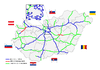 | |
|---|---|---|
| Expressways | ||
