Twin Ports
| Duluth–Superior U.S. Census Bureau Areas | ||
|---|---|---|
_map.svg.png) | ||
| Duluth MSA, MN-WI[1] | ||
| Population | 279,815 (US: 165th)[2] | |
| Largest city | Duluth | |
| Other cities | Superior - Cloquet - Carlton - Hermantown - Proctor - Rice Lake - Scanlon | |
| Density | 1,277.11/sq mi.[3] (371.13/km²) | |
| Area | 219.1 total sq mi. (753.95 km²) | |
| Counties | Saint Louis · Carlton (MN) · Douglas (WI) | |
| Area codes | 218 · (MN) 715 (WI) | |
The Twin Ports of Duluth, Minnesota and Superior, Wisconsin, are located at the western part of Lake Superior (the westernmost of North America's Great Lakes) and together are considered the largest freshwater port in the world. They are twin cities and seaports, connected to the Atlantic Ocean through the Great Lakes and the Saint Lawrence Seaway.
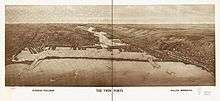
The Twin Ports are at the core of the U.S. Census Bureau's "Duluth, MN-WI Metropolitan Statistical Area",[4] which includes all of Wisconsin's Douglas County, and Minnesota's Carlton and Saint Louis counties. With a 2010 census population of 279,771, the Duluth MSA ranked as the 165th largest metropolitan area in the United States.
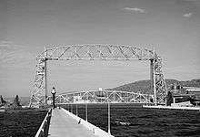
The area is home to two long bridges: the Richard I. Bong Memorial Bridge (carrying U.S. Highway 2) and the John Blatnik Bridge (carrying I-535 and U.S. Highway 53). While their central spans are not notably lengthy, the overall lengths are, with each reaching across more than 1.5 miles (2.5 km) of water. However, when visitors to the area come to see bridges, they pay more attention to the historic Aerial Lift Bridge that serves as a gateway to the port. It must be raised and lowered whenever ships enter or exit the Duluth side of the harbor, though the natural inlet closer to Superior is not similarly obstructed.
Together, the cities rank as the 19th-busiest port in the country overall (44.2 million short tons [40.1 million tonnes] per year) as of 2002, though the area is the 7th-busiest port (13.8 million short tons [12.5 million tonnes] per year) when measured on foreign exports alone.
See also
References
- ↑ U.S. Census Bureau Geography Division, Cartographic Products Management Branch (December 2005). "Metropolitan and Micropolitan Statistical Areas of the United States and Puerto Rico". Retrieved 2007-05-09.
- ↑ "Table 20. Large Metropolitan Statistical Areas--Population". 2010 Census. United States Census Bureau. Retrieved 27 October 2011.
- ↑ U.S. Census Bureau American Fact Finder (2000). "Geographic Comparison Table: United States and Puerto Rico – Metropolitan Area". Retrieved 2007-05-08. dead link
- ↑ Minnesota
External links
| Core cities |   | ||||
|---|---|---|---|---|---|
| Surrounding communities |
| ||||
| Counties |
| ||||