New Odanah, Wisconsin
| New Odanah, Wisconsin | |
|---|---|
| Census-designated place | |
 New Odanah | |
| Coordinates: 46°36′10″N 90°39′34″W / 46.60278°N 90.65944°WCoordinates: 46°36′10″N 90°39′34″W / 46.60278°N 90.65944°W | |
| Country | United States |
| State | Wisconsin |
| County | Ashland |
| Town | Sanborn |
| Area | |
| • Total | 3.886 sq mi (10.06 km2) |
| • Land | 3.801 sq mi (9.84 km2) |
| • Water | 0.085 sq mi (0.22 km2) |
| Elevation | 617 ft (188 m) |
| Population (2010)[1] | |
| • Total | 472 |
| • Density | 120/sq mi (47/km2) |
| Time zone | UTC-6 (Central (CST)) |
| • Summer (DST) | UTC-5 (CDT) |
| Area code(s) | 715 & 534 |
| GNIS feature ID | 2585069[2] |
New Odanah is a census-designated place in the town of Sanborn, Ashland County, Wisconsin, United States. Its population was 472 as of the 2010 census.[1] New Odanah is located on the Bad River Indian Reservation.
References
- 1 2 "American FactFinder". U.S. Census Bureau. Retrieved 15 April 2011.
- ↑ U.S. Geological Survey Geographic Names Information System: New Odanah, Wisconsin
| Communities | 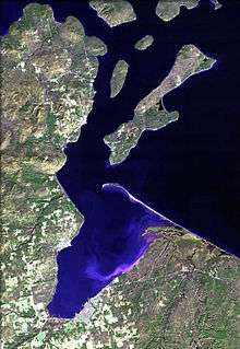 | |
|---|---|---|
| Related Geographic Aspects | ||
| Local Native American Tribes | ||
Municipalities and communities of Ashland County, Wisconsin, United States | ||
|---|---|---|
| Cities | 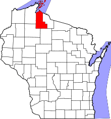 | |
| Village | ||
| Towns | ||
| CDPs | ||
| Unincorporated communities | ||
| Indian reservation | ||
| Footnotes | ‡This populated place also has portions in an adjacent county or counties | |
This article is issued from
Wikipedia.
The text is licensed under Creative Commons - Attribution - Sharealike.
Additional terms may apply for the media files.