Amagne
| Amagne | |
|---|---|
| Commune | |
_city_limit_sign.JPG) Entry to the village | |
 Amagne Location within Grand Est region  Amagne | |
| Coordinates: 49°31′05″N 4°30′06″E / 49.5181°N 4.5017°ECoordinates: 49°31′05″N 4°30′06″E / 49.5181°N 4.5017°E | |
| Country | France |
| Region | Grand Est |
| Department | Ardennes |
| Arrondissement | Rethel |
| Canton | Rethel |
| Intercommunality | Pays Rethélois |
| Government | |
| • Mayor (2014-2020) | Laurent Destrumelle |
| Area1 | 9.32 km2 (3.60 sq mi) |
| Population (2014)2 | 721 |
| • Density | 77/km2 (200/sq mi) |
| Time zone | UTC+1 (CET) |
| • Summer (DST) | UTC+2 (CEST) |
| INSEE/Postal code | 08008 /08300 |
| Elevation |
75–100 m (246–328 ft) (avg. 86.72 m or 284.5 ft) |
|
1 French Land Register data, which excludes lakes, ponds, glaciers > 1 km2 (0.386 sq mi or 247 acres) and river estuaries. 2 Population without double counting: residents of multiple communes (e.g., students and military personnel) only counted once. | |
Amagne is a French commune in the Ardennes department in the Grand Est region of northern France.
The inhabitants of the commune are known as Aquamagniens or Aquamagniennes[1]
Geography
Amagne is located some 40 km south-west of Charleville-Mézières and 40 km north-east of Rheims. It can be accessed by the D30 road running east from Rethel to the village then continuing east to Ecordal. Route D21 also comes from Novy-Chevrieres in the north-west and continues towards Attigny in the south-east. Route D45 also comes to the commune from Ambly-Fleury in the south-west. A railway from Rethel to Charleville-Mézières passes through the north-west of the commune and there is a branch line from Amagne-Lucquy through the village and continuing east to the next station at Alland'Huy-et-Sausseuil but there is no station in the commune. The station at Amagne-Lucquey just outside the commune in the west off the D21 road serves the commune.[2]
The Aisne river forms the southern boundary of the commune. The Ruisseau de Saulces passes through the village and a number of streams flow into this stream. Apart from the village the commune is entirely farmland. There are no other hamlets in the commune.[2]
Neighbouring communes and villages[2]
Places adjacent to Amagne | |
|---|---|
Administration
Jean-Baptiste Demaret (1793-1884) became mayor of Amagne in 1830 and remained so for 42 years. He was awarded the Legion of Honour.
List of Successive Mayors of Amagne[3]
| From | To | Name | Party | Position |
|---|---|---|---|---|
| 1940 | 1942 | Désiré Visoli | ||
| 1942 | 1944 | Firmin Manil | ||
| 1944 | 1953 | Goffart | ||
| 1953 | 1967 | Louis Jason | ||
| 1967 | 1995 | Paul Schmitt | ||
| 1995 | 2008 | Pierre-Gérard Braga | ||
| 2008 | 2020 | Laurent Destrumelle |
(Not all data is known)
Demography
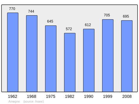
In 2009 the commune had 699 inhabitants. The evolution of the number of inhabitants is known through the population censuses conducted in the town since 1793. From the 21st century, a census of municipalities with fewer than 10,000 inhabitants is held every five years, unlike larger towns that have a sample survey every year.[Note 1]
| 1793 | 1800 | 1806 | 1821 | 1831 | 1836 | 1841 | 1846 | 1851 |
|---|---|---|---|---|---|---|---|---|
| 638 | 724 | 726 | 732 | 773 | 852 | 830 | 817 | 803 |
| 1856 | 1861 | 1866 | 1872 | 1876 | 1881 | 1886 | 1891 | 1896 |
|---|---|---|---|---|---|---|---|---|
| - | - | 667 | 660 | 669 | 656 | 697 | 732 | 762 |
| 1901 | 1906 | 1911 | 1921 | 1926 | 1931 | 1936 | 1946 | 1954 |
|---|---|---|---|---|---|---|---|---|
| 736 | 743 | 771 | 861 | 1,099 | 1,047 | 926 | 914 | 840 |
| 1962 | 1968 | 1975 | 1982 | 1990 | 1999 | 2009 | - | - |
|---|---|---|---|---|---|---|---|---|
| 770 | 744 | 645 | 572 | 612 | 705 | 699 | - | - |
Sources : Ldh/EHESS/Cassini until 1962, INSEE database from 1968 (population without double counting and municipal population from 2006)
Culture and heritage
The Church of Saint Martin (13th century)![]()

Church of Saint-Martin _%C3%A9glise%2C_vue_lat%C3%A9rale.JPG)
Side view of the church _%C3%A9glise%2C_vue_angulaire.JPG)
Angular view of the church _%C3%A9glise%2C_portail.JPG)
Entry to the church _chapelle-oratoire_Vierge_Marie.JPG)
Oratory at the church _%C3%A9glise%2C_portail%2C_d%C3%A9tail_sculpture_01.JPG)
Church Sculpture detail _%C3%A9glise%2C_portail%2C_d%C3%A9tail_sculpture_02.JPG)
Church Sculpture detail _%C3%A9glise%2C_portail%2C_d%C3%A9tail_sculpture_03.JPG)
Church Sculpture detail _%C3%A9glise%2C_portail%2C_d%C3%A9tail_sculpture_04.JPG)
Church Sculpture detail _%C3%A9glise%2C_portail%2C_d%C3%A9tail_sculpture_05.JPG)
Church Sculpture detail
Sights in the Commune
_lavoir.JPG)
The Lavoir _mairie.JPG)
The Town Hall _monument_aux_morts.JPG)
The War Memorial _croix_de_chemin.JPG)
Roadside Crosses _croix_de_chemin_B.JPG)
Roadside Cross
See also
External links
- Amagne on the old National Geographic Institute website (in French)
- Amagne on Lion1906
- Amagne on Google Maps
- Amagne on Géoportail, National Geographic Institute (IGN) website (in French)
- Amagne on the 1750 Cassini Map
- Amagne on the INSEE website (in French)
- INSEE (in French)
Notes and references
Notes
- ↑ At the beginning of the 21st century, the methods of identification have been modified by law No. 2002-276 of 27 February 2002 Archived 2016-03-06 at the Wayback Machine., the so-called "law of local democracy" and in particular Title V "census operations" which allow, after a transitional period running from 2004 to 2008, the annual publication of the legal population of the different French administrative districts. For municipalities with a population greater than 10,000 inhabitants, a sample survey is conducted annually, the entire territory of these municipalities is taken into account at the end of the period of five years. The first "legal population" after 1999 under this new law came into force on 1 January 2009 and was based on the census of 2006.
References
- ↑ Inhabitants of Ardennes (in French)
- 1 2 3 Google Maps
- ↑ List of Mayors of France (in French)
- ↑ Ministry of Culture, Mérimée PA00078330 Church of Saint Martin (in French)

- ↑ Ministry of Culture, Palissy PM08000012 Bas-relief
(in French)
- ↑ Ministry of Culture, Palissy PM08000013 Altar, 3 Retables, and 2 Bas-reliefs
(in French)
| Wikimedia Commons has media related to Amagne. |