Maisoncelle-et-Villers
| Maisoncelle-et-Villers | |
|---|---|
| Commune | |
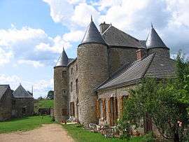 Chateau of Villers | |
 Maisoncelle-et-Villers Location within Grand Est region  Maisoncelle-et-Villers | |
| Coordinates: 49°35′52″N 4°54′38″E / 49.5978°N 4.9106°ECoordinates: 49°35′52″N 4°54′38″E / 49.5978°N 4.9106°E | |
| Country | France |
| Region | Grand Est |
| Department | Ardennes |
| Arrondissement | Sedan |
| Canton | Vouziers |
| Intercommunality | Trois Cantons |
| Government | |
| • Mayor (2008–2014) | Christelle Henriet |
| Area1 | 11.08 km2 (4.28 sq mi) |
| Population (2008)2 | 74 |
| • Density | 6.7/km2 (17/sq mi) |
| Time zone | UTC+1 (CET) |
| • Summer (DST) | UTC+2 (CEST) |
| INSEE/Postal code | 08268 /08450 |
|
1 French Land Register data, which excludes lakes, ponds, glaciers > 1 km2 (0.386 sq mi or 247 acres) and river estuaries. 2 Population without double counting: residents of multiple communes (e.g., students and military personnel) only counted once. | |
Maisoncelle-et-Villers is a commune in the Ardennes department in northern France.
Population
| Historical population | ||
|---|---|---|
| Year | Pop. | ±% |
| 1962 | 90 | — |
| 1968 | 93 | +3.3% |
| 1975 | 81 | −12.9% |
| 1982 | 59 | −27.2% |
| 1990 | 50 | −15.3% |
| 1999 | 67 | +34.0% |
| 2008 | 74 | +10.4% |
See also
References
| Wikimedia Commons has media related to Maisoncelle-et-Villers. |
This article is issued from
Wikipedia.
The text is licensed under Creative Commons - Attribution - Sharealike.
Additional terms may apply for the media files.