Pouru-Saint-Remy
| Pouru-Saint-Remy | ||
|---|---|---|
| Commune | ||
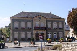 Town hall and school | ||
| ||
 Pouru-Saint-Remy Location within Grand Est region  Pouru-Saint-Remy | ||
| Coordinates: 49°40′47″N 5°05′03″E / 49.6797°N 5.0842°ECoordinates: 49°40′47″N 5°05′03″E / 49.6797°N 5.0842°E | ||
| Country | France | |
| Region | Grand Est | |
| Department | Ardennes | |
| Arrondissement | Sedan | |
| Canton | Sedan-3 | |
| Intercommunality | Pays Sedanais | |
| Government | ||
| • Mayor (2008–2014) | Gérard Manot | |
| Area1 | 10.19 km2 (3.93 sq mi) | |
| Population (2008)2 | 1,232 | |
| • Density | 120/km2 (310/sq mi) | |
| Time zone | UTC+1 (CET) | |
| • Summer (DST) | UTC+2 (CEST) | |
| INSEE/Postal code | 08343 /08140 | |
|
1 French Land Register data, which excludes lakes, ponds, glaciers > 1 km2 (0.386 sq mi or 247 acres) and river estuaries. 2 Population without double counting: residents of multiple communes (e.g., students and military personnel) only counted once. | ||

Pouru-Saint-Remy is a commune in the Ardennes department in northern France.
Population
| Historical population | ||
|---|---|---|
| Year | Pop. | ±% |
| 1962 | 1,363 | — |
| 1968 | 1,412 | +3.6% |
| 1975 | 1,385 | −1.9% |
| 1982 | 1,232 | −11.0% |
| 1990 | 1,166 | −5.4% |
| 1999 | 1,165 | −0.1% |
| 2008 | 1,232 | +5.8% |
See also
References
| Wikimedia Commons has media related to Pouru-Saint-Remy. |
This article is issued from
Wikipedia.
The text is licensed under Creative Commons - Attribution - Sharealike.
Additional terms may apply for the media files.