Dom-le-Mesnil
| Dom-le-Mesnil | ||
|---|---|---|
| Commune | ||
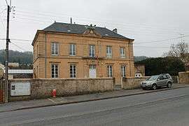 Town hall | ||
| ||
 Dom-le-Mesnil Location within Grand Est region  Dom-le-Mesnil | ||
| Coordinates: 49°41′25″N 4°48′28″E / 49.6903°N 4.8078°ECoordinates: 49°41′25″N 4°48′28″E / 49.6903°N 4.8078°E | ||
| Country | France | |
| Region | Grand Est | |
| Department | Ardennes | |
| Arrondissement | Charleville-Mézières | |
| Canton | Nouvion-sur-Meuse | |
| Intercommunality | Pays des Sources au Val de Bar | |
| Government | ||
| • Mayor (2008–2014) | Jean-Pierre Cochard | |
| Area1 | 7.99 km2 (3.08 sq mi) | |
| Population (2008)2 | 1,112 | |
| • Density | 140/km2 (360/sq mi) | |
| Time zone | UTC+1 (CET) | |
| • Summer (DST) | UTC+2 (CEST) | |
| INSEE/Postal code | 08140 /08160 | |
| Elevation |
146–297 m (479–974 ft) (avg. 160 m or 520 ft) | |
|
1 French Land Register data, which excludes lakes, ponds, glaciers > 1 km2 (0.386 sq mi or 247 acres) and river estuaries. 2 Population without double counting: residents of multiple communes (e.g., students and military personnel) only counted once. | ||

Dom-le-Mesnil is a commune in the Ardennes department in northern France.
Population
| Historical population | ||
|---|---|---|
| Year | Pop. | ±% |
| 1962 | 925 | — |
| 1968 | 979 | +5.8% |
| 1975 | 901 | −8.0% |
| 1982 | 927 | +2.9% |
| 1990 | 926 | −0.1% |
| 1999 | 1,047 | +13.1% |
| 2008 | 1,112 | +6.2% |
See also
References
| Wikimedia Commons has media related to Dom-le-Mesnil. |
This article is issued from
Wikipedia.
The text is licensed under Creative Commons - Attribution - Sharealike.
Additional terms may apply for the media files.