Alipurduar district
| Alipurduar district | |
|---|---|
| District of West Bengal | |
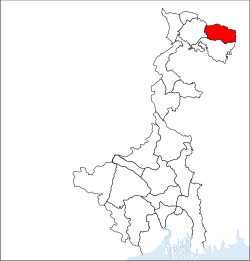 Location of Alipurduar district in West Bengal | |
| Country | India |
| State | West Bengal |
| Administrative division | Jalpaiguri |
| Headquarters | Alipurduar |
| Government | |
| • Lok Sabha constituencies | Alipurduar |
| Area | |
| • Total | 3,383 km2 (1,306 sq mi) |
| Website | Official website |
Alipurduar District is the 20th district in the state of West Bengal, India.[1] It consists of Alipurduar municipality, Falakata municipality and six community development blocks: Madarihat–Birpara, Alipurduar–I, Alipurduar–II, Falakata, Kalchini and Kumargram. The six blocks contain 66 gram panchayats and nine census towns. The district has its headquarters at Alipurduar. It was made a district on 25 June 2014.[2]
Area
Apart from the Alipurduar municipality, the district contains nine census towns and rural areas of 66 gram panchayats under six community development blocks: Madarihat–Birpara, Alipurduar–I, Alipurduar–II, Falakata, Kalchini and Kumargram.[3]
The nine census towns are Paschim Jitpur, Chechakhata, Alipurduar Railway Junction, Bholar Dabri, Sobhaganj, Falakata, Jaygaon and Uttar Latabari and Uttar Kamakhyaguri.[4]
Blocks
Madarihat block
Rural area under Madarihat (Community development block)|block consists of ten gram panchayats, viz. Bandapani, Hantapara, Madarihat, Totopara Ballalguri, Birpara–I, Khayarbari, Rangalibajna, Birpara–II, Lankapara and Shishujhumra.[3] There is no urban area under this block.[4] Madarihat and Birpara police stations serve this block.[5] Headquarters of this block is in Madarihat.[6]
Alipurduar–II block
Rural area under Alipurduar–II block consists of 11 gram panchayats, viz. Chaporer Par–I, Mahakalguri, Samuktala, Turturi, Chaparerpar–II, Majherdabri, Tatpara–I, Bhatibari, Kohinoor, Parokata and Tatpara–II.[3] Urban area under this block consists of one census town: Sobhaganj.[4] Samuktala police station serves this block.[5] Headquarters of this block is in Josodanga.
Falakata block
Rural area under Falakata block consists of 12 gram panchayats, viz. Dalgaon, Dhanirampur–II, Guabarnagar, Mairadanga, Deogaon, Falakata–I, Jateswar–I, Parangerpar, Dhanirampur–I, Falakata–II, Jateswar–II and Shalkumar.[3] Urban area under this block consists of one municipality: Falakata.[4] Falakata police station serves this block.[5] Headquarters of this block is in Falakata.[6]
Kalchini block
Rural area under Kalchini block consists of 11 gram panchayats, viz. Jaigaon–I, Jaigaon–II, Dalshing Para, Malangi, Satali, Mendabari, Latabari, Chuapara, Kalchini, Garopara and Rajabhatkawa.[3] Urban area under this block consists of two census towns: Jaigaon and Uttar Latabari.[4] Jaigaon and Kalchini police stations serve this block.[5] Headquarters of this block is in Hamiltanganj.
Kumargram block
Rural area under Kumargram block consists of 11 gram panchayats, viz. Chengamari, Khoardanga–I, Newland Kumargram Sankos, Turturikhanda, Kamakhyaguri–I, Khoardanga–II, Valka Barabisa–I, Kamakhyaguri–II, Kumargram, Raidak, Valka Barabisa–II.[3] Urban area under this block consists of one census town: [[Uttar <big>Big text<small>Small text</small></big>Kamakhyaguri]].[4] Kumargram police station serves this block.[5] Headquarters of this block is in Kumargram.[6]
- Barobisha or Barabisa is a fast developing business and cultural hub which is located on the National Highway 31C, towards Assam and is 8 km away from Bengal-Assam border.
Railway network
Alipurduar railway division has at least 710 km of railway track. It is the largest division of the NFR zone. In Alipurduar district there are two major stations, Alipurduar junction(APDJ) and New Alipurduar(NOQ). There are other stations in the district viz. hasimara railway station, raja bhat khawa, hamiltongunj etc.
Legislative segments
As per order of the Delimitation Commission in respect of the delimitation of constituencies in the West Bengal, the area under Kumargram block and seven gram panchayats under Alipurduar–II block, viz. Bhatibari, Kohinoor, Parokata, Mahakalguri, Shamuktala, Turturi and Tatpara–I will constitute the Kumargram assembly constituency of West Bengal. The Majherdabri gram panchayat under Alipurduar–II block and the area under Kalchini block will constitute the Kalchini assembly constituency. The Alipurduar municipality, the Alipurduar Railway Junction census town, and the gram panchayats of Chaporer Par–I, Chaporer Par–II and Tatpara–II under Alipurduar–II block and ten gram panchayats of Alipurduar–I block, viz. Banchukamari, Parorpar, Shalkumar–I, Vivekananda–I, Chakowakheti, Patlakhawa, Shalkumar–II, Vivekananda–II, Mathura and Tapsikhata will form the Alipurduars assembly constituency. The other gram panchayat of Alipurduar–I block, viz. Purba Kanthalbari will form the Falakata assembly constituency along with the area under Falakata block. Madarihat block will be part of Madarihat assembly constituency. Kumargram, Kalchini and Madarihat constituencies will be reserved for Scheduled tribes (ST) candidates. Falakata constituency will be reserved for Scheduled castes (SC) candidates. All these five assembly constituencies will be part of Alipurduars (Lok Sabha constituency), which will be reserved for ST candidates.[7]
Visitor attractions


- Buxa Tiger Reserve, IUCN category II national park
- Jayanti Hills
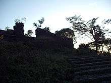
- Buxa Fort, built by British Raj
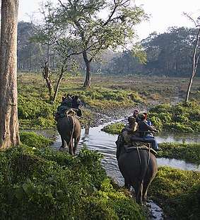
- Jaldapara National Park
- Chilapata Forests
- Jaigaon, a small town of Alipurduar and near the Bhutan border
- Rajabhatkhawa Museum at Rajabhatkhawa
- Rai matang
- Santalabari
- Rovers point
- Roopang valley
- Lepchakhawa
- Chunabhati.
- Tea Gardens
External links
References
- ↑ http://timesofindia.indiatimes.com/city/kolkata/Alipurduar-a-new-district-on-June-25/articleshow/36916065.cms
- ↑ http://www.business-standard.com/article/news-ians/alipurduar-becomes-bengal-s-20th-district-114062500725_1.html
- 1 2 3 4 5 6 "Directory of District, Sub division, Panchayat Samiti/ Block and Gram Panchayats in West Bengal, March 2008". West Bengal. National Informatics Centre, India. 19 March 2008. Archived from the original on 25 February 2009. Retrieved 21 December 2008.
- 1 2 3 4 5 6 "District Wise List of Statutory Towns (Municipal Corporation, Municipality,Notified Area and Cantonment Board), Census Towns and Outgrowths, West Bengal, 2001". Census of India, Directorate of Census Operations, West Bengal. Archived from the original on 21 July 2011. Retrieved 21 December 2008.
- 1 2 3 4 5 "List of Districts/C.D.Blocks/ Police Stations with Code No., Number of G.Ps and Number of Mouzas". Census of India, Directorate of Census Operations, West Bengal. Archived from the original on 13 February 2010. Retrieved 21 December 2008.
- 1 2 3 "Contact details of Block Development Officers". Jalpaiguri district. Panchayats and Rural Development Department, Government of West Bengal. Retrieved 26 December 2008.
- ↑ "Press Note, Delimitation Commission" (PDF). Assembly Constituencies in West Bengal. Delimitation Commission. pp. 4–5, 23. Retrieved 10 January 2009.
Cities, towns and locations in Alipurduar district | |||
|---|---|---|---|
| Cities, municipal and census towns |
| ||
| Locations other than cities and towns | |||
| Related Topics |
| ||
Places adjacent to Alipurduar district | ||||||||||
|---|---|---|---|---|---|---|---|---|---|---|
| ||||||||||